Maps of Mediterranean Sea

Mitteleuropa
1 : 3000000 Evropa střední Kartogr. Anstalt G. Freytag & Berndt
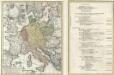
Conspectus Generalis omnium earum partium quae unquam ad Imperium Francicum vel Franco-Romanum demum Romano-Germanicum diversis temporum periodis pertinuerunt.
1 : 11000000 Mollova mapová sbírka Homann, Johann Baptist Homann, Johann Baptista - dědici
Mittel-Europa
1 : 3000000 Evropa střední G. Freytag & Berndt
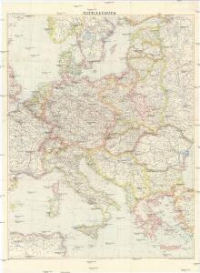
Ethnographical map of central & south eastern Europe. 1916.
1 : 4000000 First World War ethnographical map of central & south eastern Europe. 1916. War Office
Conspectus Generalis omnium earum partium quae unquam ad Imperium Francicum vel Franco-Romanum demum Romano-Germanicum diversis temporum periodis pertinuerunt.
1 : 11000000 Mollova mapová sbírka Homann, Johann Baptist Homann, Johann Baptista - dědici
Střední a jihovýchodní Europa v druhé polovici XIV. stol.

Composite: Central Europe.
1 : 2000000 John Bartholomew and Son
Sbírka map a diagramů použitých na mírových konferencích v Paříži v letech 1919 - 1920

Die grossen Friedensschlüsse II (1735 - 1812). Frankreichs, Rußlands und Englands Vorschreiten 1801-1812
1 : 20000000 Mitteleuropa, Osteuropa, Napoleonische Kriege
Nordischer Krieg 1700 - 1721
Ostmitteleuropa, Nordeuropa, Nordischer Krieg <1700-1721>
Carte des états slaves rendus indépendants par Samo, et groupés autour de lui (an 625 à 650), en face du royaume réduit des Avars, enserré à l’est par les Khazars et les Bulgares, et au sud et à l’ouest par les Slaves que l’empereur Héraclius avait établis au sud du Danube
Ostmitteleuropa Tschechische Republik Slawen Awaren Samo
Carte itinéraire de l'Europe indiquant les limites actuelles des etats
1 : 3760000 Evropa Dufour, A. H. Simonneau, Charles Ch.les Simonneau
Tabula Moderna Sarmatie Eur. Sive Hungarie, Polonie, Russie, Prussie Et Walachie [Karte], in: Claudii Ptolemei viri Alexandrini mathematice discipline philosophi doctissimi geographie opus [...], S. 248.
1 Karte aus Atlas Waldseemüller, Martin [und Ptolemaeus, Claudius] Übelin, Georg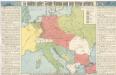
So wollten unsere Feinde Europa nach dem Kriege gestalten

Carte Generale des Chemin de Fer Europeens.
1 : 3200000 Migeon, J.
Veränderungen der Karte von Europa seit 1815
1 : 3800000 Evropa Wenzel, Joh. K. J.G. Calve'sche k. k. Hof- und Universitäts-Buchhandlung
Polen, Litthauen und das Gebiet des deutsche Ordens in den Jahren 1386 - 1480
1 : 6000000 Polen-Litauen, Preußen (Ordensstaat)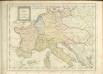

Německo - ruské pohraničí a Balkán

30. Mitteleuropa nach Beendigung des nordischen Krieges im Jahre 1721
Mitteleuropa, Ostmitteleuropa, Nordischer Krieg <1700-1721>
Carte Synoptique au tarif de l'Europe centrale trafic voyageurs, des bagages et des colis express

29. Mitteleuropa im Jahre 1650
Mitteleuropa
Mittel- u. Westeuropa zur Zeit der größten Gebietsausdehnung des Napoleonischen Reichs
1 : 13700000 Westeuropa, Mitteleuropa, Napoleon I., Frankreich, Kaiser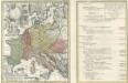
Tab. IV. Imperii Francici vel Romano German S. Romani Occid.
1 : 8500000 Mollova mapová sbírka Homann, Johann Baptist Homann, Johann Baptista - dědici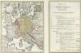
Tab. IV. Imperii Francici vel Romano-German. S. Romani Occid.
1 : 8500000 Mollova mapová sbírka Homann, Johann Baptist Homann, Johann Baptista - dědici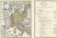
Tab. IV. Imperii Francici vel Romano-German. S. Romani Occid.
1 : 8500000 Mollova mapová sbírka Homann, Johann Baptist Homann, Johann Baptista - dědici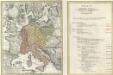
Tab. IV. Imperii Francici vel Romano-German. S. Romani Occid.
1 : 8500000 Mollova mapová sbírka Homann, Johann Baptist Homann, Johann Baptista - dědici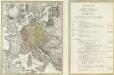
Tab. IV. Imperii Francici vel Romano-German. S. Romani Occid.
1 : 8500000 Mollova mapová sbírka Homann, Johann Baptist Homann, Johann Baptista - dědici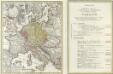
Tab. IV. Imperii Francici vel Romano-German. S. Romani Occid.
1 : 8500000 Mollova mapová sbírka Homann, Johann Baptist Homann, Johann Baptista - dědici