Maps of Mediterranean Sea

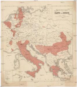
Veränderungen der Karte von Europa seit 1815
1 : 3800000 Evropa Wenzel, Joh. K. J.G. Calve'sche k. k. Hof- und Universitäts-Buchhandlung
Mittel- u. Westeuropa zur Zeit der größten Gebietsausdehnung des Napoleonischen Reichs
1 : 13700000 Westeuropa, Mitteleuropa, Napoleon I., Frankreich, Kaiser
Sbírka map a diagramů použitých na mírových konferencích v Paříži v letech 1919 - 1920

[Europa's Haupt-Gebirgs-Systeme]
Erster Band, enthaltend in vier Abtheilungen die Erscheinungen der anorganischen Natur: 1. Meteorologie und Klimatographie. 2. Hydrologie und Hydrographie. 3. Geologie. 4. Tellurischer Magnetismus Humboldt, Alexander von Verlag von Justus Perthes
[Historisch-geographischer Atlas zu den allgemeinen Geschichtswerken von C. v. Rotteck, Pölitz u. Becker] : Die Reiche im Süden Europa's im Anfange des achten Jahrhunderts
von Julius Loewenberg Lithographie von B. Herder in Freiburg im Breisg. [Freiburg im Breisgau] : [Herder]
IMPERII | CAROLI MAGNI | et vicinarum regionum | DESCRIPTIO, | Dedicata et inscripta | LVDOVICO, | REGI, VICTORI, | ET DEFENSORI ECCLESIÆ | CHRISTI
ab Auctore Petro Bertio | ejusdem Cosmographo. [Amsterdam : Joan Blaeu]
Mittel-Europa
1 : 3000000 Evropa střední G. Freytag & Berndt
Völkerkarte von Mittel-und Südosteuropa
1 : 15000000 Mitteleuropa, Südosteuropa, ethnische Gruppe
Imperium Caroli Magni [Karte], in: Novus atlas absolutissimus, Bd. 4, S. 28.
1 Karte aus Atlas Janssonius Offizin
Střední a jihovýchodní Europa v druhé polovici XIV. stol.
Imperii Caroli Magni et vicinarum regionum Descriptio [...] [Karte], in: Novus Atlas, das ist, Weltbeschreibung, Bd. 2, S. 165.
1 Karte aus Atlas Blaeu, Joan Blaeu, Willem Janszoon
Imperii Caroli Magni et vicinarum regionum Descriptio [Karte], in: Le théâtre du monde, ou, Nouvel atlas contenant les chartes et descriptions de tous les païs de la terre, Bd. 2, S. 165.
1 Karte aus Atlas Blaeu, Willem Janszoon und Blaeu, Joan Blaeu, Willem Janszoon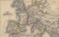
Das Zeitalter der Hohenstaufen
Mitteleuropa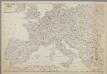
Centraal-, West-, en Zuid-Europa
1 : 3700000 [S.l. : s.n.]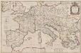
Imperii Caroli Magni et vicinarum regionum Descriptio [Karte], in: Theatrum orbis terrarum, sive, Atlas novus, Bd. 2, S. 167.
1 Karte aus Atlas Blaeu, Joan Blaeu, Willem Janszoon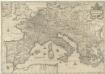
Imperium Caroli Magni
1 : 7400000 Mollova mapová sbírka Janssonius, Johannes Janssonius, Johannes I
Central Europe.
1 : 7303000 Fisher, Richard Swainson
Mitteleuropa
1 : 3000000 Evropa střední Kartogr. Anstalt G. Freytag & Berndt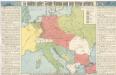
So wollten unsere Feinde Europa nach dem Kriege gestalten

Ethnographical map of central & south eastern Europe. 1916.
1 : 4000000 First World War ethnographical map of central & south eastern Europe. 1916. War Office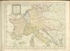

Conspectus Generalis omnium earum partium quae unquam ad Imperium Francicum vel Franco-Romanum demum Romano-Germanicum diversis temporum periodis pertinuerunt.
1 : 11000000 Mollova mapová sbírka Homann, Johann Baptist Homann, Johann Baptista - dědici
Carte Generale des Chemin de Fer Europeens.
1 : 3200000 Migeon, J.
Conspectus Generalis omnium earum partium quae unquam ad Imperium Francicum vel Franco-Romanum demum Romano-Germanicum diversis temporum periodis pertinuerunt.
1 : 11000000 Mollova mapová sbírka Homann, Johann Baptist Homann, Johann Baptista - dědici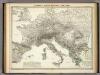
Europa's Haupt-Gebirgs Systeme.
1 : 6640000 Berghaus, Heinrich
Europa zur Zeit Napoleons
Europa Napoleon I., Frankreich, Kaiser
Composite: Central Europe.
1 : 2000000 John Bartholomew and Son
A new map of ancient Italy, together with the adjoyning islands of Sicily, Sardinia, and Corsica, shewing their principal divisions, cities, towns, rivers, mountains &c.
from A new sett of maps both of antient and present geography : wherein not only the latitude and longitude of many places are corrected according to the latest observations, but also the most remarkable differences of antient and present geography may be quickly discern'd by a bare inspection or comparing of correspondent maps, which seems to be the most natural and easy method to lead young students (for whose use the work is principally intended) unto a competent knowledge of the geographical science : together with a geographical treatise particularly adapted to the use and design of these maps / by Edward Wells, M.A. and student of Christ-Church, Oxon.
Patriarchati Occidentalis. (1826)
1 : 12100000 Tanner, Henry S.