Maps of Usti Nad Labem

Kojeditz in Böhmen
1 : 2880 Kojetice (Ústí nad Labem, Česko)
Kogeditz - c3259-1-002 - Kaiserpflichtexemplar der Landkarten des stabilen Katasters
1 : 2880
Kogeditz - c3259-1-001 - Kaiserpflichtexemplar der Landkarten des stabilen Katasters
1 : 2880
Neudörfl - c5240-1-001 - Kaiserpflichtexemplar der Landkarten des stabilen Katasters
1 : 2880
Neudörfl - c5240-1-003 - Kaiserpflichtexemplar der Landkarten des stabilen Katasters
1 : 2880
Neudörfl - c5240-1-004 - Kaiserpflichtexemplar der Landkarten des stabilen Katasters
1 : 2880
Neudörfl - c5240-1-002 - Kaiserpflichtexemplar der Landkarten des stabilen Katasters
1 : 2880
Budowe - c0645-1-002 - Kaiserpflichtexemplar der Landkarten des stabilen Katasters
1 : 2880
Budowe - c0645-1-001 - Kaiserpflichtexemplar der Landkarten des stabilen Katasters
1 : 2880
Presey - c0572-1-003 - Kaiserpflichtexemplar der Landkarten des stabilen Katasters
1 : 2880
Presey - c0572-1-002 - Kaiserpflichtexemplar der Landkarten des stabilen Katasters
1 : 2880
Presey - c0572-1-001 - Kaiserpflichtexemplar der Landkarten des stabilen Katasters
1 : 2880
Ober Sedlitz - c7447-1-001 - Kaiserpflichtexemplar der Landkarten des stabilen Katasters
1 : 2880
Ober Sedlitz - c7447-1-002 - Kaiserpflichtexemplar der Landkarten des stabilen Katasters
1 : 2880
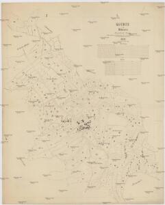
Karte des politischen Bezirkes Aussig

Karte des Politisches und Schulbezirkes Leitmeritz...


Die Schlacht bei Kulm am 29. u. 30. August 1813
Chlumec (Ústí nad Labem, Česko) Loquens, Jos. Bormann, E.
Die Herschaft Toeplitz im Lautmeritzer Creisse des Königreichs Boehmen

Touristen-Karte des Aussiger Mittel- und Erzgebirgs-Vereines
1 : 75000 Krušné hory (Česko a Německo) Kroitzsch, Carl Mittel- und Erzgebirgesverein
Karte der Bezirkshauptmannschaft zugleich Strafgerichtsbezirk Leitmeritz
1 : 222500 Litoměřice-oblast (Česko) von dem Lehrpersonale der Leitmeritzer k.k. Hauptschule
Litoměřice a okolí
1 : 75000 Litoměřice (Česko : oblast) Vojenský zeměpisný ústav
Litoměřice
1 : 75000 Litoměřice-oblast (Česko) Vojenský zeměpisný ústav
Litoměřice
1 : 75000 Litoměřice (Česko : oblast) Vojenský zeměpisný ústav
III. vojenské mapování 3752
1 : 75000
Soubor přehledných map pro plánování a statistiku: 3752 – Litoměřice

Karte der Teplitzer Umgebung und der Nachbarbezirke
1 : 143000 Teplice-oblast (Česko) C. Weigend
Ústí n. L. a Litoměřice
1 : 75000 Benešov nad Ploučnicí (Česko : oblast) Vojenský zeměpisný ústav
Bezirk Aussig

Aussig und Leitmeritz
1 : 75000 Litoměřice (Česko : oblast) Acham, Stefan K. u. k. militär-geographisches Institut
Aussig und Leitmeritz
1 : 75000 Litoměřice (Česko : oblast) Acham, Stefan K. u. k. Militärgeographisches Institut