Maps of North Kordufan

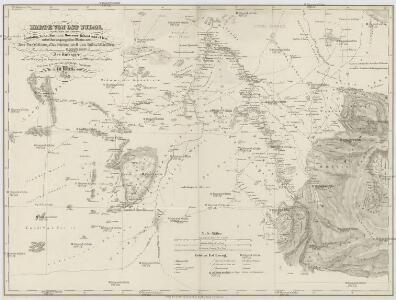
KARTE VON OST SUDAN
1 : 1800000 Dárfúr (Súdán) Russegger, Joseph E. Schweiyerbart'schen Buchhandlung
Geognostiche Karte von ost Sudan, umfaßsend dei Länder Kordofan, Nuba, Sennaar, Roserres, Faßsokl und el Pert nebst den angrenzenden Theilen von Dar Fur, Nubien, Ab eßsinien und den Galla Ländern
1 : 1800000 Etiopie E. Schweizerbart'schen Buchhandlung
Darfour et Kordofan. Afrique 24.
1 : 1641836 Vandermaelen, Philippe, 1795-1869
Anglo-Egyptian Sudan 1:250,000, Lake Keilak
Anglo-Egyptian Sudan / compiled and zincograhed at the Survey Office Khartoum. Sudan. Maṣlaḥat al-Misāḥah. Khartoum : Survey Office
Map of the egyptian Sudan
1 : 2253080 Súdán Intelligence branch, War Office
Soudan égyptien & Abyssinie d'après divers documents
1 : 4000000 Amend, H Genève : imp. Noverraz & fils
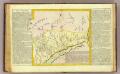
Carta originale della Spedizione Borghese-Matteucci : nel Kordofan e Dar For secondo i rilievi del sottotenente A.M. Massari e le Esplorazioni anteriori
1 : 3000000 Cora, Guido, 1851-1917 Istituto Geografico Guido Cora
Countries In The Northern Tropical Regions of Africa.
Fullarton, A. & Co.
Upper Nubia and Abyssinia.
1 : 2854868 Johnston, Alexander Keith
Carte du Kordoufan et des pays adjacents
Ruppel, Edouard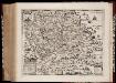
Habessinia seu Abassia, presbyteri Johannis regio perperam dicta ... / Jobi Lodolfi [cart.] ; Christianus Ludolfus J. Filius delineavit ex autographo Parentis
1 : 2400000 Annotatie: Origineel is Blad 211 in atlas factice Jobus Ludolphus 1624-1704; Christianus Ludolfus [Amsterdam] : [s.n.]
Jobi Ludolfi Habessinia seu Abassia, presbyteri Johannis regio
Etiopie Ludolf, Christian Habess, Gregorius
Karte von Aethiopien (H'abeš, Takah & Ost-Senar)
1 : 2500000 Eritrea Heuglin, Theodor von Bruce Hermann Costenoble
Liberia (1914)
Liberia, TSGS 2083. Great Britain. General Staff. Topographical Section. [London] : [TSGS, War Office]
Sennaar. Afrique 25.
1 : 1641836 Vandermaelen, Philippe, 1795-1869
Donga. Afrique 31.
1 : 1641836 Vandermaelen, Philippe, 1795-1869
Neueste Karte von Nubien, Habesch, Kordofan und Darfur
Grosser Hand-Atlas über alle Theile der Erde in 170 Karten Meyer, J. Verlag des Bibliographischen Instituts
Nubien, Habesch, Kordofan, Darfur.
1 : 6300000 Radefeld, Carl Christian Franz, 1788-1874
The Anglo-Egyptian Sudan
1 : 3000000 Súdán Ordnance survey office
The Anglo-Egyptian Sudan
1 : 3000000 Súdán War Office
Abyssinien oder (Habesch) Nubien - Burnu
1 : 55650000 Etiopie Jättnig, Karl Gleditsch
Phyto-geographische Karte des Nilgebietes und der Uferländer des Rothen Meeres
1 : 10000000 Nil (řeka : oblast) Schweinfurth, Georg Justus Perthes
Nubia, Abyssinia.
1 : 5100000 Hall, S. (Sidney)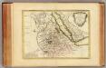
Nubie, Abissinie.
1 : 7000000 Bonne, Rigobert, 1727-1794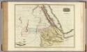
Abyssinia, Nubia &c.
1 : 4000000 Pinkerton, John, 1758-1826
Egypte, Nubie et Abyssinie.
1 : 9300000 Malte-Brun, Conrad, 1775-1826
Ägypten
Egypte, Nubie, Abissinie.
1 : 8300000 Clouet, J. B. L. (Jean-Baptiste Louis), b. 1730
Cours du Nil.
1 : 5900000 Andriveau-Goujon, J.