Maps of North Kordufan

Soudan égyptien & Abyssinie d'après divers documents
1 : 4000000 Amend, H Genève : imp. Noverraz & fils
Map of the egyptian Sudan
1 : 2253080 Súdán Intelligence branch, War Office
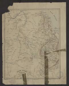
Carte du Kordoufan et des pays adjacents
Ruppel, Edouard
KARTE VON OST SUDAN
1 : 1800000 Dárfúr (Súdán) Russegger, Joseph E. Schweiyerbart'schen Buchhandlung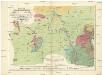
Geognostiche Karte von ost Sudan, umfaßsend dei Länder Kordofan, Nuba, Sennaar, Roserres, Faßsokl und el Pert nebst den angrenzenden Theilen von Dar Fur, Nubien, Ab eßsinien und den Galla Ländern
1 : 1800000 Etiopie E. Schweizerbart'schen Buchhandlung
Carta originale della Spedizione Borghese-Matteucci : nel Kordofan e Dar For secondo i rilievi del sottotenente A.M. Massari e le Esplorazioni anteriori
1 : 3000000 Cora, Guido, 1851-1917 Istituto Geografico Guido Cora
Darfour et Kordofan. Afrique 24.
1 : 1641836 Vandermaelen, Philippe, 1795-1869
Donga. Afrique 31.
1 : 1641836 Vandermaelen, Philippe, 1795-1869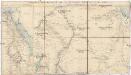
Stanford's popular map of the seat of military operations in the Súdan
1 : 1450000 Chartúm (Súdán) Stanford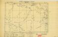
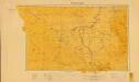
Anglo-Egyptian Sudan 1:250,000, Lake Keilak
Anglo-Egyptian Sudan / compiled and zincograhed at the Survey Office Khartoum. Sudan. Maṣlaḥat al-Misāḥah. Khartoum : Survey Office
Sudan [Anglo-Egyptian] 1:250,000, Lake No
Anglo-Egyptian Sudan / Survey Office. Sudan. Maṣlaḥat al-Misāḥah. [Southampton] : For D. Survey (WO & AM) by Ordnance Survey
Phyto-geographische Karte des Nilgebietes und der Uferländer des Rothen Meeres
1 : 10000000 Nil (řeka : oblast) Schweinfurth, Georg Justus Perthes
The Anglo-Egyptian Sudan
1 : 3000000 Súdán Ordnance survey office
The Anglo-Egyptian Sudan
1 : 3000000 Súdán War Office
Nubia, Abyssinia.
1 : 5100000 Hall, S. (Sidney)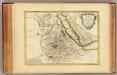
Nubie, Abissinie.
1 : 7000000 Bonne, Rigobert, 1727-1794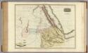
Abyssinia, Nubia &c.
1 : 4000000 Pinkerton, John, 1758-1826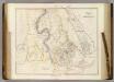
Nubia and Abyssinia.
1 : 4118400 Arrowsmith, John
Neueste Karte von Nubien, Habesch, Kordofan und Darfur
Grosser Hand-Atlas über alle Theile der Erde in 170 Karten Meyer, J. Verlag des Bibliographischen Instituts
[Tok řeky Nilu]
1 : 7500000 Nil (řeka)
Nubien, Habesch, Kordofan, Darfur.
1 : 6300000 Radefeld, Carl Christian Franz, 1788-1874
Map of the route explored by Captns. Speke & Grant from Zanzibar to Egypt : showing the outfall of the Nile from the Victoria Nyanza (Lake) and the various Negro territories discovered by them
1 : 5800000 Edward Stanford Ltd Edward Stanford
Countries In The Northern Tropical Regions of Africa.
Fullarton, A. & Co.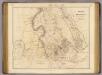
Nubia, Abyssinia.
1 : 3860000 Arrowsmith, John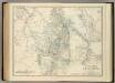
Upper Nubia and Abyssinia.
1 : 2854868 Johnston, Alexander Keith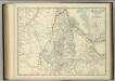
Upper Nubia and Abyssinia.
1 : 2854868 Johnston, W. & A.K.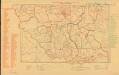
Parliamentary constituencies ― 1957 [Sudan]
Parliamentary constituencies ― 1957 [Sudan]. Sudan. Maṣlaḥat al-Misāḥah. Khartoum : Sudan Survey Department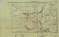
Southern Sudan (1951) Distribution of Population During Wet Season
Southern Sudan. Distribution of population during wet season. Corrected Nov. 1951. Topo. No. S. 918. Khartoum : Sudan Survey Dept.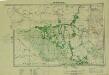
Southern Sudan (1951) Seasonal Cattle Movements
Southern Sudan. Seasonal cattle movements. Corrected Nov. 1951. Topo. No. S919. Khartoum : Sudan Survey Dept.