Maps of Transdanubia

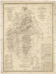
Mappa geographica almae dioecesis Weszprimiensis per inclytos comitatus Weszprim, Simigh et Zala
1 : 240000 Veszprém-oblast (Maďarsko) Vizer, Stephan Kopácsy, Joseph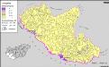
A horvátok aránya és száma Délnyugat-Magyarországon 1980-ben
Transdanubien (Süd) Kroaten, Siedlung Bottlik, Zsolt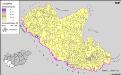
A horvátok aránya és száma Délnyugat-Magyarországon 1941-ben
Transdanubien (Süd) Kroaten, Siedlung Bottlik, Zsolt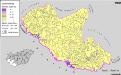
Kroaten in Südwest-Ungarn 1980
Transdanubien (Süd) Kroaten, Siedlung Bottlik, Zsolt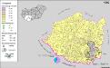
A németek településterülete a szomszédsági mutató alapján Dél-Dunántúlon 1980-ban
Ungarn (Süd) Deutsche, Siedlung Bottlik, Zsolt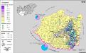
A németek településterülete a szomszédsági mutató alapján Dél-Dunántúlon 1941-ban
Ungarn (Süd) Deutsche, Siedlung Bottlik, Zsolt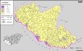
A horvátok aránya és száma Délnyugat-Magyarországon 1880-ben
Transdanubien (Süd) Kroaten, Siedlung Bottlik, Zsolt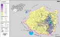
A németek településterülete a szomszédsági mutató alapján Dél-Dunántúlon 1880-ban
Ungarn (Süd) Deutsche, Siedlung Bottlik, Zsolt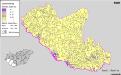
Kroaten in Südwest-Ungarn 1880
Transdanubien (Süd) Kroaten, Siedlung Bottlik, Zsolt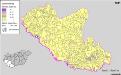
Kroaten in Südwest-Ungarn 1941
Transdanubien (Süd) Kroaten, Siedlung Bottlik, Zsolt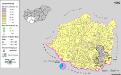
Siedlungsgebiet der Deutschen nach dem Nachbarschaftsindex für Süd-Transdanubien 1980
Ungarn (Süd) Deutsche, Siedlung Bottlik, Zsolt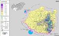
Siedlungsgebiet der Deutschen nach dem Nachbarschaftsindex für Süd-Transdanubien 1941
Ungarn (Süd) Deutsche, Siedlung Bottlik, Zsolt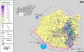
Siedlungsgebiet der Deutschen nach dem Nachbarschaftsindex für Süd-Transdanubien 1880
Ungarn (Süd) Deutsche, Siedlung Bottlik, Zsolt
Bez titulu: Západní Maďarsko

Comitat Somogy
1 : 300000
Veszprémer Comitat
1 : 280000 Veszprém (Maďarsko : oblast)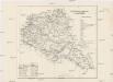
Veszprémer Comitat
1 : 280000 Veszprém-oblast (Maďarsko)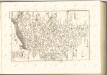

C. Sümeghiensis
Ungarn Komitat Somogy
Somogy vármegye térképe
1 : 400000 Kaposvár (Maďarsko) Kogutowicz, Manó Magyar Földrajzi Intézet
Mappa Comitatvs Soproniensis 1758
1 : 1250000 Mollova mapová sbírka Zeller, Sebastian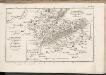
C. Szaladiensis. Tab. III
Ungarn Komitat Zala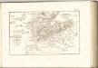

Stuhlweissenburg 162, uit: Special-Karte von Mittel-Europa / nach amtlichen Quellen bearbeitet von W. Liebenow
1 : 300000 titelvariant: W. Liebenow's Mittel-Europa; Annotatie: Titel boven de bladen: W. Liebenow's Mittel-Europa Johannes Wilhelm Liebenow 1822-1897 Frankfurt a. M. : Ludwig Ravenstein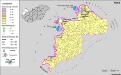
A németek településterülete a szomszédsági mutató alapján Nyugat-Magyarországon 1941-ban
Ungarn, Transdanubien, Deutsche, Siedlung Bottlik, Zsolt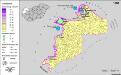
A németek településterülete a szomszédsági mutató alapján Nyugat-Magyarországon 1880-ban
Ungarn, Transdanubien, Deutsche, Siedlung Bottlik, Zsolt
Übersichtskarte zu den Operationen vor u. nach der Schlacht bei Raab

A horvátok aránya és száma Nyugat-Magyarországon 1941-ben
Transdanubien Kroaten, Siedlung Bottlik, Zsolt
Kroaten in West-Ungarn 1980
Transdanubien Kroaten, Siedlung Bottlik, Zsolt