Maps of Libeň
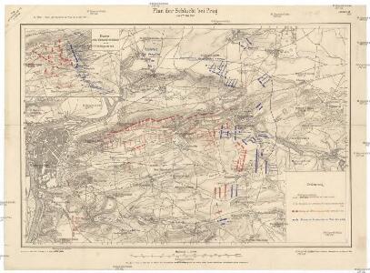
Plan der Schlacht bei Prag am 6ten Mai 1757
1 : 25000 Štěrboholy (Praha, Česko) Hoen, Maximilian von L.W. Seidel & Sohn
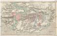
Plan de la Bataille... le 6 May 1757

Schlacht bei Prag, den 6-ten May 1757
Bez titulu: Plán železniční dopravy v Praze a okolí
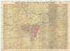
Bataille de Praag, en Bohéme, gagnée par le roi de Prusse, sur l'armée des impériaux, commandée par le prince Charles de Lorraine, le 6. may, 1757
1 : 39000 Praha (Česko)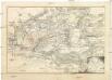
Bataille de Praag, en Bohéme, gagnée par le roi de Prusse, sur l'armée des impériaux, commandée par le prince Charles de Lorraine, le 6. may, 1757
1 : 39000 Praha (Česko)
Bataille de Prague
1 : 62300 Praha (Česko) Therbu Coentgen, Heinrich Hugo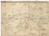
Graenzkarte der k. k. Reservatjagdbefugnisz bei Hrdlorzes, Vissoczan, Key, Hostawitz, Chwalla, Malleschitz, Lieben und Hlaupietin &
1 : 15000 Hloubětín (Praha, Česko) Guberth, Karl
Situace nové spojovací tratě Vršovice - Libeň

Orientační plán Hlavního města Prahy
Plan von der den 6ten May A.o 1757. bey Prag, zwischen der kayserl. königl. Armee unter Befehl des G.F.M. Graffen von Broune, und der königl. preussischen Armee unter Commando sr. Maj. selbsten, vorgefallenen grossen Bataille
Praha (Česko) in der Raspischen Buchhandlung
Praha : informační plán
1 : 15000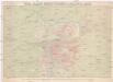
Král. hlavní město Praha s okolím r. 1908
1 : 10000 Praha (Česko : oblast) Hurtig, Alfred V. Neubert
Výškopisný plán hlavního města Prahy s okolím

Hlavní město Praha s okolím
[Praha]
Praha (Česko) Včela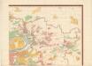
Orientierungsplan der Hauptstadt Prag
Jiřík, Rudolf
Grundrisz der königlichen Hauptstadt Prag
1 : 4500 Praha (Česko) Jüttner, Josef Drda, Josef Jan Alois auf Veranlassung und Kosten des böhmischen Nationalmuseums
Grundrisz der königlichen Hauptstadt Prag
1 : 4500 Praha (Česko) Jüttner, Josef Drda, Josef Jan Alois auf Veranlassung und Kosten des böhmischen Nationalmuseums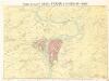
Král. Hlavní město Praha s okolím r. 1848.

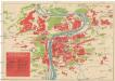
Nejnovější a nejúplnější plán královského hlavního města Prahy a obcí sousedních

Nejnovější a nejúplnější plán královského hlav. města Prahy a obcí sousedních : s úplným seznamem ulic, náměstí atd.
1 : 12000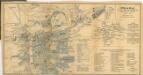
Praha, hlavní město republiky Československé
1 : 30000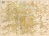
Plan der Stadt Prag = Plán Prahy : mit den neuesten Benennungen : s nejnovějším pojmenováním ulic
1 : 16000
Síť kanalisace Prahy
Král. hlavní město Praha s okolím r. 1848
1 : 10000 Praha (Česko)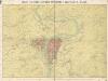
Královské hlavní město Praha s okolím r. 1848
Král. hlavní město Praha s okolím r. 1848

Král. hlavní město Praha s okolím r. 1908
1 : 10000