Maps of Hloubětín
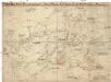
Graenzkarte der k. k. Reservatjagdbefugnisz bei Hrdlorzes, Vissoczan, Key, Hostawitz, Chwalla, Malleschitz, Lieben und Hlaupietin &
1 : 15000 Hloubětín (Praha, Česko) Guberth, Karl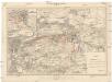
Plan der Schlacht bei Prag am 6ten Mai 1757
1 : 25000 Štěrboholy (Praha, Česko) Hoen, Maximilian von L.W. Seidel & Sohn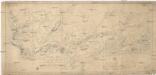
Situations-Plan des Reservat Jagel Terrains bey Prag gegen Chwala so weil dieses von gegenwärtigen Herrn Kommandirenden auf 6 Jahre gepachtet worden ist
1 : 15000 Trampusek, Franz Le Roy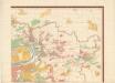
Orientierungsplan der Hauptstadt Prag
Jiřík, Rudolf
Hlavní město Praha s okolím

Plán Líbně a Vysočan se sousedními obcemi

Keeg - c3763-1-001 - Kaiserpflichtexemplar der Landkarten des stabilen Katasters
1 : 2880
Keeg - c3763-1-004 - Kaiserpflichtexemplar der Landkarten des stabilen Katasters
1 : 2880
Keeg - c3763-1-003 - Kaiserpflichtexemplar der Landkarten des stabilen Katasters
1 : 2880
Keeg - c3763-1-002 - Kaiserpflichtexemplar der Landkarten des stabilen Katasters
1 : 2880
Wisoczan - c8937-1-004 - Kaiserpflichtexemplar der Landkarten des stabilen Katasters
1 : 2880
Wisoczan - c8937-1-001 - Kaiserpflichtexemplar der Landkarten des stabilen Katasters
1 : 2880
Wisoczan - c8937-1-002 - Kaiserpflichtexemplar der Landkarten des stabilen Katasters
1 : 2880
Wisoczan - c8937-1-003 - Kaiserpflichtexemplar der Landkarten des stabilen Katasters
1 : 2880
Hlaupetin - c1883-1-001 - Kaiserpflichtexemplar der Landkarten des stabilen Katasters
1 : 2880
Hlaupetin - c1883-1-004 - Kaiserpflichtexemplar der Landkarten des stabilen Katasters
1 : 2880
Hlaupetin - c1883-1-003 - Kaiserpflichtexemplar der Landkarten des stabilen Katasters
1 : 2880
Hlaupetin - c1883-1-002 - Kaiserpflichtexemplar der Landkarten des stabilen Katasters
1 : 2880
Hlaupetin - c1883-1-005 - Kaiserpflichtexemplar der Landkarten des stabilen Katasters
1 : 2880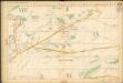
Auto-Praha : automobilní plán Velké Prahy a příručka pro automobilisty
1 : 50000
Alt Straschnitz (Staro Strašnic) - c7282-1-004 - Kaiserpflichtexemplar der Landkarten des stabilen Katasters
1 : 2880
Alt Straschnitz (Staro Strašnic) - c7282-1-002 - Kaiserpflichtexemplar der Landkarten des stabilen Katasters
1 : 2880
Alt Straschnitz (Staro Strašnic) - c7282-1-001 - Kaiserpflichtexemplar der Landkarten des stabilen Katasters
1 : 2880
Alt Straschnitz (Staro Strašnic) - c7282-1-003 - Kaiserpflichtexemplar der Landkarten des stabilen Katasters
1 : 2880
[Vojenské postavení mezi Prosekem a Kbely]
Kbely (Praha, Česko)
Malleschitz - c4410-1-002 - Kaiserpflichtexemplar der Landkarten des stabilen Katasters
1 : 2880
Malleschitz - c4410-1-003 - Kaiserpflichtexemplar der Landkarten des stabilen Katasters
1 : 2880
Malleschitz - c4410-1-001 - Kaiserpflichtexemplar der Landkarten des stabilen Katasters
1 : 2880
Výškopisný plán hlavního města Prahy s okolím


