Maps of Somali Peninsula

Le royaume d'Adel
1 : 9600000 Jemen Bonne, Rigobert André
116-17. Eritrea, Etiopia, Somalia.
1 : 5000000 Touring club italiano
Ostafrika – Vých. Afrika

[Kaart], uit: Colonie dell'Africa Orientale Italiana
1 : 4000000 Annotatie: Ondertitel op omslag: Eritrea - Somalia Italiana - Etiopia - Somalia Francese e Britannica; Annotatie geografische gegevens: Inzetkrt.: [Omgevingskaart]. - 1:50.000.000 Milano : Vallardi
British Somaliland and Sokotra
in British Somaliland and Sokotra. [With a map.] iv, 40 p. ; 8 -- . Great Britain. Foreign Office. Historical Section.
Abessinien
1 : 5000000 Etiopie G. Freytag & Berndt
Programma di massima della triangolazione geodetica di I° ordine dell' altopiano etiopico
1 : 3000000 Eritrea Istituto geografico militare
Itinerari di due viaggi al Madagascar eseguiti dall'inge. E. Cortese nel 1887
1 : 1000000 Società geografica italiana
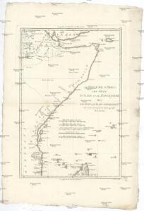
Adel. Afrique 33.
1 : 1641836 Vandermaelen, Philippe, 1795-1869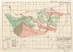
Plant ecology (Somalia)
[A collection of maps illustrating an economic survey and reconnaissance report on British Somaliland, G.P. numbers 2577 - 2593]. Great Britain. Army. East Africa Force. [S.l.] : 157 (E.A. & S.R.) Base Svy. Coy., E.A.E.
Cote d'Ajan. Afrique 37.
1 : 1641836 Vandermaelen, Philippe, 1795-1869
British Somaliland, GSGS 2991 (1922)
British Somaliland, GSGS 2991. Great Britain. General Staff. Geographical Section. [London] : [GSGS, War Office]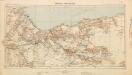
British Somaliland [showing routes] (1926)
British Somaliland [showing routes], GSGS 2991(b). Great Britain. General Staff. Geographical Section. [London] : [GSGS, War Office]
Cestovatele Viléma Němce přehledná mapa Císařství habešského s poznámkami zoografickými a místopisnými
1 : 2070000 Etiopie Němec, Vilém Československá grafická unie
Partie, la Cote d'Adel. Afrique 34.
1 : 1641836 Vandermaelen, Philippe, 1795-1869
Monoemugi. Afrique 40.
1 : 1641836 Vandermaelen, Philippe, 1795-1869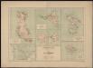
Carte des îles Comores
1 : 200000 France. Service géographique des colonies [Paris] : Ministère des Colonies
Carte de l'Abyssinie, du pays des Galla, de Choa et d'Ifat
1 : 2500000 dressée par Mrs. Combes et Tamisier dessinée par A. Vuillemin ; gravée par Massuet ; écrite par Martin ainé Paris : Desessart
Carte générale d'Abyssinie
1 : 1800000 dressée par M. le lieutenant de vaisseau Théophile Lefebvre pendant son voyage d'exploration en 1839, 40, 41, 42, 43 Paris : Arthus Bertrand
Carte d'Abyssinie et des contrées adjacentes dressée partie d'après des observations faites sur les lieux par l'auteur, partie d'après les informations prises dans le pays en 1809 et 1810
1 : 5000000 par Henry Salt [S.l.] : [s.n.]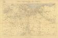
Carta dimostrativa della Etiopia (Sheet 6)
Carta dimostrativa della Etiopia, in 6 fogli e 2 aggiunte, alla scala di 1 : 100,000. Compilata dal Capitano ... Ethiopia de Chaurand, etc. [Rome]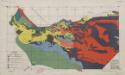
Soil map (Somalia)
[A collection of maps illustrating an economic survey and reconnaissance report on British Somaliland, G.P. numbers 2577 - 2593]. Great Britain. Army. East Africa Force. [S.l.] : 157 (E.A. & S.R.) Base Svy. Coy., E.A.E.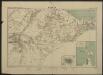
Carte de la côte française des Somalis et régions avoisinantes. Harrar
1 : 500000 Meunier, A., cartographe [Paris] : Service géographique des colonies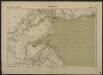
Carte de la côte française des Somalis et régions avoisinantes. Djibouti
1 : 500000 Meunier, A., cartographe [Paris] : Service géographique des colonies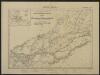
Carte de la côte française des Somalis et régions avoisinantes. Addis-Ababa
1 : 500000 Meunier, A., cartographe [Paris] : Service géographique des colonies
Geologische Übersicht der Reisen des Bergassessors W. Bornhardt zwischen Kilwa-Kivindye und dem Rovuma
1 : 500000 Geographische Verlagshandlung Dietrich Reimer (Ernst Vohsen)
Archipel des Comores
1 : 1000000 France. Service géographique de l'armée [Paris] : Service géographique de l'Etat-major
Iles Glorieuses
1 : 500000 Madagascar. Service géographique [Tananarive] : Service géographique de Madagascar
Archipel des Comores
1 : 500000 Madagascar. Service géographique [Tananarive] : Service géographique de Madagascar
Diego-Suarez
1 : 500000 Madagascar. Service géographique [Tananarive] : Service géographique de Madagascar