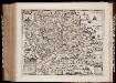
Maps of Ethiopian Highlands

Carte de l'Abyssinie, du pays des Galla, de Choa et d'Ifat
1 : 2500000 dressée par Mrs. Combes et Tamisier dessinée par A. Vuillemin ; gravée par Massuet ; écrite par Martin ainé Paris : Desessart
Carte générale d'Abyssinie
1 : 1800000 dressée par M. le lieutenant de vaisseau Théophile Lefebvre pendant son voyage d'exploration en 1839, 40, 41, 42, 43 Paris : Arthus Bertrand
Carte d'Abyssinie et des contrées adjacentes dressée partie d'après des observations faites sur les lieux par l'auteur, partie d'après les informations prises dans le pays en 1809 et 1810
1 : 5000000 par Henry Salt [S.l.] : [s.n.]
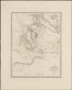
Carta dimostrativa della Etiopia (Sheet 5)
Carta dimostrativa della Etiopia, in 6 fogli e 2 aggiunte, alla scala di 1 : 100,000. Compilata dal Capitano ... Ethiopia de Chaurand, etc. [Rome]
Carta della colonia Eritrea
1 : 1500000 Italie. Ministero degli Affari esteri [Florence] : Ministero degli affari esteri
Abissinie. Afrique 32.
1 : 1641836 Vandermaelen, Philippe, 1795-1869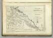
Map of Abyssinia.
1 : 1470000 Melish, John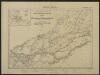
Carte de la côte française des Somalis et régions avoisinantes. Addis-Ababa
1 : 500000 Meunier, A., cartographe [Paris] : Service géographique des colonies
Carta speciale della regione attorno a Massaua
1 : 200000 Eritrea Cora, Guido
1 : 125,000 Somaliland Protectorate. Geological Survey. D.C.S. 1076, Abdal Qadr
1 : 125,000 Somaliland Protectorate. Geological Survey. D.C.S. 1076. [Surbiton] : Directorate of Colonial Surveys
1 : 125,000 Somaliland Protectorate. Geological Survey. D.C.S. 1076, Gocti
1 : 125,000 Somaliland Protectorate. Geological Survey. D.C.S. 1076. [Surbiton] : Directorate of Colonial Surveys
Carta della Colonia Eritrea. Buia
1 : 100000 Istituto geografico militare. Italie [Florence] : Istituto geografico militare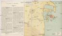
Schizzo topografico di Massaua e dintorni
Eritrea Antonio Vallardi
Asmara [Town plan] (1938)
Asmara [Town plan], MOD Misc 190. Great Britain. Directorate of Military Survey. [Cairo] : [Middle East Command]
Carta dimostrattiva della regione compresa fra Massaua, Keren, Aksum e Adigrat
1 : 400000 Eritrea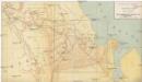
I confini tra l'Abissinia e i possedimenti italiani
1 : 400000 Eritrea Antonio Vallardi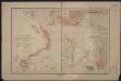
Port d'Obock et possessions françaises sur la mer Rouge
1 : 700000 Paris : Charles Bayle et Cie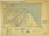
Somaliland 1:250 000, Zeila
Somaliland 1:250 000 , Series GSGS 3927. Series in seventeen sheets covers former British Somaliland only. Sheetlines based on grid. Sheets numbered consecutively; 1 to 17. Great Britain. War Office. General Staff. Geographical Section. [S.l.] : War Office.
Countries In The Northern Tropical Regions of Africa.
Fullarton, A. & Co.
Abyssinia, surrounding countries.
1 : 6450000 Rand McNally and Company
Ethiopia. Pergamon World Atlas.
1 : 5000000 Polish Army Topography Service
AEthiopisches Hochland Alpenland Habesch und Vorstuffe von Darfur und Sennaar
Dárfúr (Súdán) Arrowsmith, John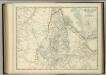
Upper Nubia and Abyssinia.
1 : 2854868 Johnston, W. & A.K.
Cestovatele Viléma Němce přehledná mapa Císařství habešského s poznámkami zoografickými a místopisnými
1 : 2070000 Etiopie Němec, Vilém Československá grafická unie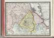
Upper Nubia and Habesh or Abyssina.
1 : 5000000 Rand McNally and Company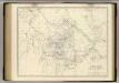
Nubia, Abyssinia.
1 : 2854868 Johnston, Alexander Keith, 1804-1871
Upper Nubia and Abyssinia.
1 : 2854868 Johnston, Alexander Keith
Upper Nubia and Abyssinia.
1 : 2854868 Johnston, Alexander Keith
Seconda edizione della nuova carta dei domini e protettorati italiani nell' Eritrea e regioni limitrofe
1 : 1500000 Eritrea Ministero della guerra