Maps of Amhara

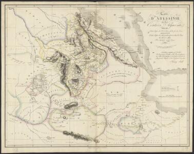
Carte d'Abyssinie et des contrées adjacentes dressée partie d'après des observations faites sur les lieux par l'auteur, partie d'après les informations prises dans le pays en 1809 et 1810
1 : 5000000 par Henry Salt [S.l.] : [s.n.]
Carte générale d'Abyssinie
1 : 1800000 dressée par M. le lieutenant de vaisseau Théophile Lefebvre pendant son voyage d'exploration en 1839, 40, 41, 42, 43 Paris : Arthus Bertrand
Carte de l'Abyssinie, du pays des Galla, de Choa et d'Ifat
1 : 2500000 dressée par Mrs. Combes et Tamisier dessinée par A. Vuillemin ; gravée par Massuet ; écrite par Martin ainé Paris : Desessart
Carta della colonia Eritrea
1 : 1500000 Italie. Ministero degli Affari esteri [Florence] : Ministero degli affari esteri
Jobi Ludolfi Habessinia seu Abassia, presbyteri Johannis regio
Etiopie Ludolf, Christian Habess, Gregorius
Map of Abyssinia.
1 : 1470000 Melish, John
Carte de la côte française des Somalis et régions avoisinantes. Djibouti
1 : 500000 Meunier, A., cartographe [Paris] : Service géographique des colonies
Carte de la côte française des Somalis et régions avoisinantes. Harrar
1 : 500000 Meunier, A., cartographe [Paris] : Service géographique des colonies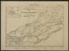
Carte de la côte française des Somalis et régions avoisinantes. Addis-Ababa
1 : 500000 Meunier, A., cartographe [Paris] : Service géographique des colonies
Karte von dem groessten Theil des Landes Jemen Imame, Kaukeban &
1 : 775000 Jemen Niebuhr, Carsten Benedicti, Hieronymus F.A. Schraembl
Terrae Yemen maxima pars, seu imperii Imami, principatus Kaukebân, nec non ditionum Haschid u Bekîl, Nehhm, Chaulân, Abu Arîsch et Aden, tabula : ex observationibus astronomicis et hodometricis jussu et sumtibus potentissimor. Daniae regum Friderici V, et Christiani VII. institutis, delineata
1 : 1200000 auctore C. Niebuhr Gustav Conrad Lotter sculps. Aug. Vind. : Tob. Conr: Lotter geogr. excud.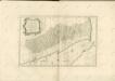

Carta dimostrattiva della regione compresa fra Massaua, Keren, Aksum e Adigrat
1 : 400000 Eritrea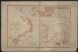
Port d'Obock et possessions françaises sur la mer Rouge
1 : 700000 Paris : Charles Bayle et Cie
Somaliland 1:250 000, Sa-Wer
Somaliland 1:250 000 , Series GSGS 3927. Series in seventeen sheets covers former British Somaliland only. Sheetlines based on grid. Sheets numbered consecutively; 1 to 17. Great Britain. War Office. General Staff. Geographical Section. [S.l.] : War Office.
Somaliland 1:250 000, Tug Wajale
Somaliland 1:250 000 , Series GSGS 3927. Series in seventeen sheets covers former British Somaliland only. Sheetlines based on grid. Sheets numbered consecutively; 1 to 17. Great Britain. War Office. General Staff. Geographical Section. [S.l.] : War Office.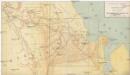
I confini tra l'Abissinia e i possedimenti italiani
1 : 400000 Eritrea Antonio Vallardi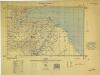
Somaliland 1:250 000, Zeila
Somaliland 1:250 000 , Series GSGS 3927. Series in seventeen sheets covers former British Somaliland only. Sheetlines based on grid. Sheets numbered consecutively; 1 to 17. Great Britain. War Office. General Staff. Geographical Section. [S.l.] : War Office.
Carta speciale della regione attorno a Massaua
1 : 200000 Eritrea Cora, Guido
1 : 125,000 Somaliland Protectorate. Geological Survey. D.C.S. 1076, Abdal Qadr
1 : 125,000 Somaliland Protectorate. Geological Survey. D.C.S. 1076. [Surbiton] : Directorate of Colonial Surveys
1 : 125,000 Somaliland Protectorate. Geological Survey. D.C.S. 1076, Adadleh
1 : 125,000 Somaliland Protectorate. Geological Survey. D.C.S. 1076. [Surbiton] : Directorate of Colonial Surveys
1 : 125,000 Somaliland Protectorate. Geological Survey. D.C.S. 1076, Bawn
1 : 125,000 Somaliland Protectorate. Geological Survey. D.C.S. 1076. [Surbiton] : Directorate of Colonial Surveys
1 : 125,000 Somaliland Protectorate. Geological Survey. D.C.S. 1076, Qabri Bahar
1 : 125,000 Somaliland Protectorate. Geological Survey. D.C.S. 1076. [Surbiton] : Directorate of Colonial Surveys
1 : 125,000 Somaliland Protectorate. Geological Survey. D.C.S. 1076, Laferug
1 : 125,000 Somaliland Protectorate. Geological Survey. D.C.S. 1076. [Surbiton] : Directorate of Colonial Surveys
1 : 125,000 Somaliland Protectorate. Geological Survey. D.C.S. 1076, Gocti
1 : 125,000 Somaliland Protectorate. Geological Survey. D.C.S. 1076. [Surbiton] : Directorate of Colonial Surveys
Carta della Colonia Eritrea. Buia
1 : 100000 Istituto geografico militare. Italie [Florence] : Istituto geografico militare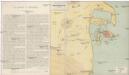
Schizzo topografico di Massaua e dintorni
Eritrea Antonio Vallardi
Asmara [Town plan] (1938)
Asmara [Town plan], MOD Misc 190. Great Britain. Directorate of Military Survey. [Cairo] : [Middle East Command]
Somaliland 1:250 000, Berbera
Somaliland 1:250 000 , Series GSGS 3927. Series in seventeen sheets covers former British Somaliland only. Sheetlines based on grid. Sheets numbered consecutively; 1 to 17. Great Britain. War Office. General Staff. Geographical Section. [S.l.] : War Office.