Maps of Brazilian Highlands

Roteiro em Brazil no 1817-1821 do Dr. Pohl
1 : 16480000 Brazílie
Maritima Brasiliæ universæ / [Joan Blaeu]
1 : 6375000 Annotatie: Kaart vertoont de plaatsen aan de westkust van Brazilië; Origineel is Blad 216 in atlas factice; Annotatie geografische gegevens: Schaalstokken op kaart: 60 Milliaria Germanica 15 uni gradui respondentia (=7,2 cm), en: 70 Milliaria Hispanica 17 1/2 gradui respondentia (=7,2 cm); West boven Joan Blaeu 1597/98-1673 [Amsterdam] : [Blaeu]
Novus Brasiliae Typus
Blaeu, Willem Janszoon
Accuratissima Brasiliae Tabula. [Karte] Baya de todos os Sanctos [Nebenkarte] Villa d'Olinda de Pernambuco [Nebenkarte], in: Gerardi Mercatoris et I. Hondii Newer Atlas, oder, Grosses Weltbuch, Bd. 2, S. 407.
1 Karte aus Atlas Mercator, Gerhard und Hondius, Jodocus Jansson, Jan
Accuratissima Brasiliae tabula
1 : 4000000 Henricus Hondius excudit Amstelodami : Henricus Hondius
Maritima Brasiliae Universae
Blaeu, Joan [Blaeu]
Nova et accurata Brasiliae totius tabula
1 : 6000000 Blaeu, Joan, 1596-1673 Nunc apud Petrum Schenk Junior
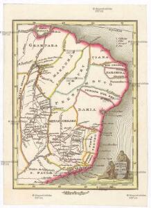
Brésil et pays des Amazones
1 : 10700000 Amazonka-oblast Bonne, Rigobert André
Eastern Brazil.
1 : 8400000 Sharpe, J.
South America 4.
1 : 2800000 Arrowsmith, Aaron
Brazil - East - Central. Pergamon World Atlas.
1 : 5000000 Polish Army Topography Service
Novus Brasiliae Typus [Karte] [Baya de todos os Sanctos] [Nebenkarte], in: Novus Atlas, das ist, Weltbeschreibung, Bd. 2, S. 343.
1 Karte aus Atlas Blaeu, Joan Blaeu, Willem Janszoon
Mapa geologico do estado de Minas Geraes
1 : 1000000 Guimarães, Djalma Belo-Horizonte : Imprensa Official
229. Brazil, South East, Sao Paulo Region, Rio de Janeiro. The World Atlas.
1 : 3750000 USSR (Union of Soviet Socialist Republics).
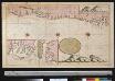
De kust van Brazielia vertoonende de klippen van de Abreolhos int grood
Brazil Gerard van Keulen
East Coast of South America. Brazil, Middle Provinces.
Fullarton, A. & Co.
Partie du Bresil. Amer. Merid. 12.
1 : 1641836 Vandermaelen, Philippe, 1795-1869
Partie du Bresil. Amer. Merid. 13.
1 : 1641836 Vandermaelen, Philippe, 1795-1869
Partie du Bresil. Amer. Merid. 18.
1 : 1641836 Vandermaelen, Philippe, 1795-1869
Partie du Bresil. Amer. Merid. 19.
1 : 1641836 Vandermaelen, Philippe, 1795-1869
Partie du Bresil. Amer. Merid. 24.
1 : 1641836 Vandermaelen, Philippe, 1795-1869
Partie du Bresil. Amer. Merid. 28.
1 : 1641836 Vandermaelen, Philippe, 1795-1869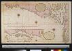
Een gedeelte van de kust van Brasilia tussen Cabo Noord en Cabo de Cuma
Brazil Gerard van Keulen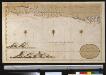
Een gedeelte van Brazilia tussen Cabo de Cuma en Bahia Baxa
Brazil Gerard van Keulen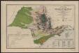
Carta geral do estado de Sao Paulo. Com indicaçoes sobre a agricultura, commercio, instrucçao publica, industria e colonisaçao
1 : 2000000 Comissão Geográfica e Geológica. São Paulo, Brésil [São Paulo] : Commissão Geográphica e Geológica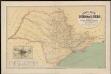
Carta geral do estado de Sao Paulo. Organizada pela Commissao Geographica e Geologica
1 : 1000000 Comissão Geográfica e Geológica. São Paulo, Brésil São Paulo : Weiszflog Irmãos
Carta de progresso da Commissao Geographica e Geologica de S. Paulo
1 : 2000000 Comissão Geográfica e Geológica. São Paulo, Brésil [São Paulo] : Commissão Geográphica e Geológica
Partie du Bresil. Amer. Merid. 23.
1 : 1641836 Vandermaelen, Philippe, 1795-1869
Estado de Sao Paulo, mappa geologico physico politico e economico
1 : 1000000 Paris : Girard et Barrère