Maps of Camden

Insurance Plan of London Vol. X: sheet 246
1 : 480 This detailed 1889 plan of London is one of a series of thirty-five sheets in an atlas originally produced to aid insurance companies in assessing fire risks. The building footprints, their use (commercial, residential, educational, etc.), the number of floors and the height of the building, as well as construction materials (and thus risk of burning) and special fire hazards (chemicals, kilns, ovens) were documented in order to estimate premiums. Names of individual businesses, property lines, and addresses were also often recorded. Together these maps provide a rich historical shapshot of the commercial activity and urban landscape of towns and cities at the time. The British Library holds a comprehensive collection of fire insurance plans produced by the London-based firm Charles E. Goad Ltd. dating back to 1885. These plans were made for most important towns and cities of the British Isles at the scales of 1:480 (1 inch to 40 feet), as well as many foreign towns at 1:600 (1 inch to 50 feet). Chas E Goad Limited Chas E Goad Limited
Insurance Plan of London Vol. X: sheet 247
1 : 480 This detailed 1889 plan of London is one of a series of thirty-five sheets in an atlas originally produced to aid insurance companies in assessing fire risks. The building footprints, their use (commercial, residential, educational, etc.), the number of floors and the height of the building, as well as construction materials (and thus risk of burning) and special fire hazards (chemicals, kilns, ovens) were documented in order to estimate premiums. Names of individual businesses, property lines, and addresses were also often recorded. Together these maps provide a rich historical shapshot of the commercial activity and urban landscape of towns and cities at the time. The British Library holds a comprehensive collection of fire insurance plans produced by the London-based firm Charles E. Goad Ltd. dating back to 1885. These plans were made for most important towns and cities of the British Isles at the scales of 1:480 (1 inch to 40 feet), as well as many foreign towns at 1:600 (1 inch to 50 feet). Chas E Goad Limited Chas E Goad Limited
PARISH OF CHRIST CHURCH. SURREY
1 : 3168 The title of this parish plan appears at middle left, with scale bar and compass star above the title, and an inset view of the parish church at bottom left. Christ Church was built in 1737 on the site of a church built in 1670 which was demolished after sinking in the Lambeth Marsh. Gardner, H.
Plan of the Cities of London and Westminster, the Borough of Southwark and parts adjoining, shewing every house. By R. Horwood. [Scale, about 25 inches = 1 mile]
Horwood, Richard
London VII.85 - OS London Town Plan
1 : 1056 Topographic maps Ordnance Survey Ordnance Survey
Insurance Plan of London Vol. X: sheet 264
1 : 480 This detailed 1889 plan of London is one of a series of thirty-five sheets in an atlas originally produced to aid insurance companies in assessing fire risks. The building footprints, their use (commercial, residential, educational, etc.), the number of floors and the height of the building, as well as construction materials (and thus risk of burning) and special fire hazards (chemicals, kilns, ovens) were documented in order to estimate premiums. Names of individual businesses, property lines, and addresses were also often recorded. Together these maps provide a rich historical shapshot of the commercial activity and urban landscape of towns and cities at the time. The British Library holds a comprehensive collection of fire insurance plans produced by the London-based firm Charles E. Goad Ltd. dating back to 1885. These plans were made for most important towns and cities of the British Isles at the scales of 1:480 (1 inch to 40 feet), as well as many foreign towns at 1:600 (1 inch to 50 feet). Chas E Goad Limited Chas E Goad Limited
Insurance Plan of London Vol. X: sheet 244
1 : 480 This detailed 1889 plan of London is one of a series of thirty-five sheets in an atlas originally produced to aid insurance companies in assessing fire risks. The building footprints, their use (commercial, residential, educational, etc.), the number of floors and the height of the building, as well as construction materials (and thus risk of burning) and special fire hazards (chemicals, kilns, ovens) were documented in order to estimate premiums. Names of individual businesses, property lines, and addresses were also often recorded. Together these maps provide a rich historical shapshot of the commercial activity and urban landscape of towns and cities at the time. The British Library holds a comprehensive collection of fire insurance plans produced by the London-based firm Charles E. Goad Ltd. dating back to 1885. These plans were made for most important towns and cities of the British Isles at the scales of 1:480 (1 inch to 40 feet), as well as many foreign towns at 1:600 (1 inch to 50 feet). Chas E Goad Limited Chas E Goad Limited
Insurance Plan of London Vol. X: sheet 248-1
1 : 480 This detailed 1889 plan of London is one of a series of thirty-five sheets in an atlas originally produced to aid insurance companies in assessing fire risks. The building footprints, their use (commercial, residential, educational, etc.), the number of floors and the height of the building, as well as construction materials (and thus risk of burning) and special fire hazards (chemicals, kilns, ovens) were documented in order to estimate premiums. Names of individual businesses, property lines, and addresses were also often recorded. Together these maps provide a rich historical shapshot of the commercial activity and urban landscape of towns and cities at the time. The British Library holds a comprehensive collection of fire insurance plans produced by the London-based firm Charles E. Goad Ltd. dating back to 1885. These plans were made for most important towns and cities of the British Isles at the scales of 1:480 (1 inch to 40 feet), as well as many foreign towns at 1:600 (1 inch to 50 feet). Chas E Goad Limited Chas E Goad Limited
Insurance Plan of London Vol. X: sheet 264~r-2
1 : 480 This detailed 1889 plan of London is one of a series of thirty-five sheets in an atlas originally produced to aid insurance companies in assessing fire risks. The building footprints, their use (commercial, residential, educational, etc.), the number of floors and the height of the building, as well as construction materials (and thus risk of burning) and special fire hazards (chemicals, kilns, ovens) were documented in order to estimate premiums. Names of individual businesses, property lines, and addresses were also often recorded. Together these maps provide a rich historical shapshot of the commercial activity and urban landscape of towns and cities at the time. The British Library holds a comprehensive collection of fire insurance plans produced by the London-based firm Charles E. Goad Ltd. dating back to 1885. These plans were made for most important towns and cities of the British Isles at the scales of 1:480 (1 inch to 40 feet), as well as many foreign towns at 1:600 (1 inch to 50 feet). Chas E Goad Limited Chas E Goad Limited
Insurance Plan of City of London Vol. IV: sheet 76-2
1 : 480 This detailed 1887 plan of London is one of a series of twenty-three sheets in an atlas originally produced to aid insurance companies in assessing fire risks. The building footprints, their use (commercial, residential, educational, etc.), the number of floors and the height of the building, as well as construction materials (and thus risk of burning) and special fire hazards (chemicals, kilns, ovens) were documented in order to estimate premiums. Names of individual businesses, property lines, and addresses were also often recorded. Together these maps provide a rich historical shapshot of the commercial activity and urban landscape of towns and cities at the time. The British Library holds a comprehensive collection of fire insurance plans produced by the London-based firm Charles E. Goad Ltd. dating back to 1885. These plans were made for most important towns and cities of the British Isles at the scales of 1:480 (1 inch to 40 feet), as well as many foreign towns at 1:600 (1 inch to 50 feet). Chas E Goad Limited Chas E Goad Limited
Plan of a New Street near Christ Church
1 : 600 The plan features scale bar along the bottom. It also shows the ground plot of Christ Church in grey, Blackfriars Road and the proposed new street in brown, the extension to the church yard in green, and the neighbouring properties in pink.
A PLAN of the Parish of Christ Church shewing the present Sewers surrounding the same.
1 : 8448 This plan shows the existing sewage system and the proposals for a new sewage canal through Great Charlotte Street. A level section of the River Thames appears along the right margin, next to sewers in diagram. The title of the plan appears at the top margin.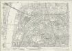
London (1915- Numbered sheets) V.14 (includes: Lambeth St Mary; Southwark) - 25 Inch Map
1 : 2500 Topographic maps Ordnance Survey Ordnance Survey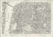
London (Edition of 1894-96) LXXVI (includes: Lambeth St Mary; Southwark) - 25 Inch Map
1 : 2500 Topographic maps Ordnance Survey Ordnance Survey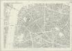
London (First Editions c1850s) XLIV (includes: Lambeth St Mary; Southwark) - 25 Inch Map
1 : 2500 Topographic maps Ordnance Survey Ordnance Survey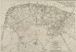
PLAN OF THE STREETS, ROADS &c. BETWEEN LAMBETH AND SOUTHWARK
1 : 5280 This is a plan of Saint George's Fields, between Lambeth and Southwark, with the title and scale bar in a table at bottom right and compass rose at bottom centre. The plan shows the proposals for Blackfriars Road and the southern approaches to Blackfriars Bridge as finally laid out during the period 1770-1800. Kitchin, Thomas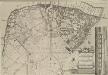
A Plan of the Streets, Roads &c. Between Black Fryers Bridge &c.
The title of this plan of Saint George's Fields, Southwark, appears in a table at bottom right, with a compass star at bottom centre, scale bar at top right, and an inset view of Blackfriars Bridge along the right margin. The plan shows the proposals for Blackfriars Road and the southern approaches to Blackfriars Bridge as they were finally laid during the last quarter of the 18th Century. Kitchin, Thomas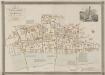
GENERAL PLAN OF THAT PART OF THE CITY OF LONDON THAT WAS DESTROYED BY THE GREAT FIRE OF 1666; SHOWING THE PRESENT STATE THEREOF
1 : 2431 This retrospective map compares pre-fire London with the city of the 1830s. The title and publisher's imprint appear at top left, with a reference table at bottom right, scale bar at bottom centre, and woodcut view of the Temple at top right. The map shows churches, halls and public buildings destroyed in the fire in grey,with contemporary buildings in pink. Wishaw, Francis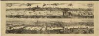
Views of London in 1616 and 1890
1 : 1
Insurance Plan of London Vol. X: Key Plan
1 : 480 This "key plan" indicates coverage of the Goad 1889 series of fire insurance maps of London that were originally produced to aid insurance companies in assessing fire risks. The building footprints, their use (commercial, residential, educational, etc.), the number of floors and the height of the building, as well as construction materials (and thus risk of burning) and special fire hazards (chemicals, kilns, ovens) were documented in order to estimate premiums. Names of individual businesses, property lines, and addresses were also often recorded. Together these maps provide a rich historical shapshot of the commercial activity and urban landscape of towns and cities at the time. The British Library holds a comprehensive collection of fire insurance plans produced by the London-based firm Charles E. Goad Ltd. dating back to 1885. These plans were made for most important towns and cities of the British Isles at the scales of 1:480 (1 inch to 40 feet), as well as many foreign towns at 1:600 (1 inch to 50 feet). Chas E Goad Limited Chas E Goad Limited
A Map of the Surrey Side the Thames from Westminster Bridge to the Borough. With a Plan for laying out the Roads, to BLACK FRYARS BRIDGE
The title of this map of St. George's Fields, Southwark, appears below the plan with key at bottom right. Alternative plans for laying out Blackfriars Road are indicated by double-dotted and pricked lines. The mile-long road was finally finished in the last quarter of the 18th Century.
Insurance Plan of London: sheet 2
This detailed 1889 plan of London is one of a series of six sheets in an atlas originally produced to aid insurance companies in assessing fire risks. The building footprints, their use (commercial, residential, educational, etc.), the number of floors and the height of the building, as well as construction materials (and thus risk of burning) and special fire hazards (chemicals, kilns, ovens) were documented in order to estimate premiums. Names of individual businesses, property lines, and addresses were also often recorded. Together these maps provide a rich historical shapshot of the commercial activity and urban landscape of towns and cities at the time. The British Library holds a comprehensive collection of fire insurance plans produced by the London-based firm Charles E. Goad Ltd. dating back to 1885. These plans were made for most important towns and cities of the British Isles at the scales of 1:480 (1 inch to 40 feet), as well as many foreign towns at 1:600 (1 inch to 50 feet). Chas E Goad Limited Chas E Goad Limited
A MAP or GROVNDPLOT of the Citty of London within the Suburbes thereof
Engraved map of London with title in square tablet at top right and reference table with key to churches and other landmarks at bottom right. The map clearly shows the extent of the damage to the city caused by the great fire of 1666: the barren city wards in contrast with bird’s eye views of surviving buildings just outside the city. Also by Hollar is the inset map at bottom left entitled A General Map of the Whole Citty of London, Westminster and all the Suburbs. Smaller in scale but more extensive in coverage, the inset map shows at a glance the extent of the damage caused by the fire. This small map was probably the basis for the many variations on the theme of the London Verbrandt which were published in Amsterdam by Venckel and De Wit in the aftermath of the fire. The fire destroyed nearly the whole city 13,000 buildings circa and though the casualties were few 8 people only died directly because of the fire thousands were made homeless. Hollar, Wenceslaus
A MAP or GROVNDPLOT OF THE CITTY OF LONDON, WITH THE SVBVRBES THEREOF
1 : 9386 Engraved map of London with title along the top, reference table with key to the city's landmarks and churches at top right and bottom left respectively and with compass star and scale bar at bottom right. The map shows the extent of the damage to the city caused by the great fire of 1666; the barren city wards contrasting with birds eye views of surviving buildings just outside the city. This small map was probably the basis for the many variations on the theme of the "London Verbrandt" which were published in Amsterdam by Venckel and De Wit in the aftermath of the fire. The fire broke out at a bakers shop on Pudding Lane near London Bridge on the 2nd of September 1666. The fire destroyed nearly the whole city 13.000 buildings circa and though the casualties were few only eight people died because of the fire thousands were made homeless. Hollar, Wenceslaus
A New and Plaine Mapp of the CITTY of LONDON Shewing the Streets, Lanes, Allies, Courts, Churches Halls and other remarkable places as they are now rebuilt
The title of this map of the City of London appears along the top, with tables of references at top left and right, a compass rose depicted along the river course. St Paul’s Cathedral, the Tower of London, the Roman wall and ships sailing along the Thames are all shown pictorially. The map's publisher, John Overton, had acquired Peter Stent's stock in the mid-17th Century. This stock included many maps by leading Tudor cartographers. His son Henry succeeded him in 1703 and continued the family's publishing business. Overton, John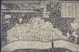
An exact Surveigh of the Streets, Lanes, and Churches contained within the ruines of the City of London, first described in six plats
N. Brooke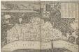
AN EXACT SURVEIGH OF THE STREETS LANES AND CHVRCHES CONTAINED WITHIN THE RVINES OF THE CITY OF LONDON FIRST DESCRIBED IN SIX PLATS
1 : 3620 This map was reduced by John Leake from a large-scale survey on six sheets produced in December 1666 to assess the damage caused by the great fire. No copy of this large scale survey has ever been found. This is the second edition of this map, Updated and issued in 1669 with a dedication to Sir William Turner, The Lord Mayor of London for that year. The map's title appears along the top of the manuscript, With the City arms and dedication at top centre. The key to buildings destroyed in the fire appears in a table at top right, With a compass star at bottom right, Scale bar and imprint at bottom left, And an illustration of the city on fire inset at top left. The location of livery halls destroyed in the fire is indicated by their respective coats of arms. Letters identify individual City wards, With ward boundaries indicated by a pecked line. Buildings outside the city walls, Undamaged by the fire, Are represented three dimensionally. Leake, John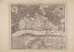
An Exact Map representing the conditions of the late famous and flourishing City of London
1 : 6336 Engraved map of London and suburbs (including Lincoln Inn Fields, Finsbury Fields, Smith Fields and Bankside in Southwark) in which barren city wards contrast with birds eye views of surviving buildings outside the city, showing at a glancethe extent of the damage to the city caused by the great fire of 1666. The map features title along the top, with arms of the city and compass rose depicted at top left and right respectively. Also by Pricke is the inset map in the panel at the foot of the plate. Entitled "A map of the Whole City of London and Westminster with the Suburbs, Whearein May Be Judged What Proportion is Burnt and What Remains Standing", this smaller scale map (two inches to the mile) is flanked by reference tables with key to churches and halls of the London Livery companies. Pricke, Robert
A guide for Cuntrey men In the famous Cittey of LONDON by the helpe of wich plot they shall be able to know how farr it is to any Street...
This 1593 map is the direct forbear of the modern London A-Z. This copy comes from the 1653 edition of John Norden's 'Speculum Britainiae' (literally: 'Mirror of Britain'), re-issued after Norden's death and sold by Peter Stent of Newgate. Around the edges of the map appear the coats of arms of the twelve most influential and wealthy city guilds: the 'Great Liveries'. Guild members became known as liverymen because they wore a distinctive livery or uniform. At top right is the Merchant Tailors company, which made tents and padded tunics during the middle ages. This is reflected by the tent motif on the coat of arms. Norden, John


