Maps of Ukraine

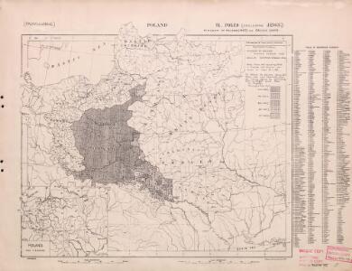
Poland: Poles (excluding Jews)
1 : 3000000 Series of maps on various aspects of Poland. Poles (excluding Jews). Kingdom of Poland (1897) an Galicia (1900). Distribution of Poles, showing minorities. War Office
Poland: Language. No.1
1 : 3000000 Series of maps on various aspects of Poland. Languages in 1910-1913. War Office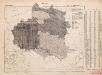
Poland: Language. No.2
1 : 3000000 Series of maps on various aspects of Poland. Distribution of languages according to various authorities. War Office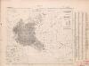
Poland: Poles
1 : 3000000 Series of maps on various aspects of Poland. Distribution of Poles showing minorities. War Office
Poland: Density
1 : 3000000 Series of maps on various aspects of Poland. Density. Number of inhabitants per square kilometre. War Office
Die Teilungen Polens
1 : 10000000 Polen-Litauen Teilungen Polens
Volker und Reiche der Slaven zwischen Elbe und Don bis 1125.
1 : 5000000 Spruner von Merz, Karl
Die Teilungen Polens
1 : 15000000 Polen Teilungen Polens
Poland: Lithuanians, Little Russians and Czechs
1 : 3000000 Series of maps on various aspects of Poland. Distribution of Lithuanians, Little Russians and Czechs, showing minorities. War Office
Mapa rozmieszczenia gleb na ziemiach polskich
1 : 6300000 Polen Geologie Arct, Michał
Polen bis zu seinem Untergange 1795.
1 : 5000000 Spruner von Merz, Karl
Poland: Jews
1 : 3000000 Series of maps on various aspects of Poland. Distribution of Jewish minorities. War Office
Polen nach der ersten Theilung 1772
1 : 20000000 Polen Teilung Polens <1772>
Polen nach der zweiten Theilung 1793
1 : 20000000 Polen Teilung Polens <1793>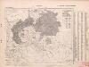
Poland: Germans and White Russians
1 : 3000000 Series of maps on various aspects of Poland. Poland. Germans and White Russians. Distribution of Germans and White Russians, showing minorities War Office
Mapa rozmieszczenia bogactw kopalnych na ziemiach polskich
1 : 6300000 Polen Geologie Arct, Michał
Polen und Litthauen unter den Jagjellonen 1386-1572.
1 : 5000000 Spruner von Merz, Karl
[Geschichtlich-geographische Entwickelung des Zuwachses und der Abnahme des polnischen Reiches vom Jahre 992 bis zum Jahre 1831, dargestellt in fünf Karten] : V. Karte der Wiederherstellung Polens, 1807-1831
1 : 4800000 entw. u. gez. durch F.A. von Witzleben [Berlin] : [Reimer]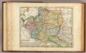
Poland.
1 : 6300000 Moll, Herman, d. 1732
Polen vor dem Frieden v. Andrussow 1667
1 : 20000000 Polen-Litauen Russisch-polnischer Krieg <1654-1667>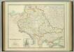
South-West Russia.
1 : 3456000 Johnston, W. & A.K.
[Geschichtlich-geographische Entwickelung des Zuwachses und der Abnahme des polnischen Reiches vom Jahre 992 bis zum Jahre 1831, dargestellt in fünf Karten] : II. Karte von Polen unter dem Jagellonen, 1386-1572
1 : 4800000 entw. u. gez. durch F.A. von Witzleben [Berlin] : [Reimer]
Polen nach der dritten Theilung 1795
1 : 20000000 Polen Teilung Polens <1795>
[Geschichtlich-geographische Entwickelung des Zuwachses und der Abnahme des polnischen Reiches vom Jahre 992 bis zum Jahre 1831, dargestellt in fünf Karten] : IV. Karte der 3 Theilungen Polens von 1773-1795
1 : 4800000 entw. u. gez. durch F.A. von Witzleben [Berlin] : [Reimer]
Polen nach dem Frieden von Oliva 1660
Polen Oliva / Friede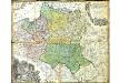
Mappa Geographica Regni Poloniae
Mayer, Tobias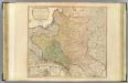
Poland, Prussia.
1 : 2300000 Faden, William, 1750?-1836
[Geschichtlich-geographische Entwickelung des Zuwachses und der Abnahme des polnischen Reiches vom Jahre 992 bis zum Jahre 1831, dargestellt in fünf Karten] : III. Karte von Polen von dem Aussterben der Jagellonen bis zur ersten Theilung, 1572-1772
1 : 4800000 entw. u. gez. durch F.A. von Witzleben [Berlin] : [Reimer]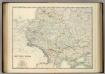
South-West Russia.
1 : 3456000 Johnston, Alexander Keith