Maps of Shropshire
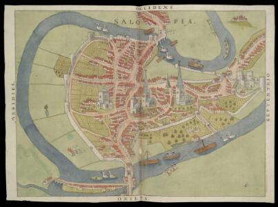
Plan of Shrewsbury
This is a manuscript planof Shrewsbury. It forms part of an atlas that belonged to William Cecil Lord Burghley, Elizabeth I’s Secretary of State. Burghley used this atlas to illustrate domestic matters. Here Shrewsbury is recorded as a walled town, adjacent to the city gate leading from "franc ville". Lord Burghley has added "ye welsh gate". The author and date of the map are not known, however its presentation suggests a date of around the 1540s. The map is presented in the bird's eye view style, with information recorded pictorially and differentiation between different buildings detailed. Human activity and wildlife is also illustrated. There is no indication of scale, with the swans depicted significantly larger than the people. The inclusion of this map in the atlas reveals a little about Lord Burghley's philosophy of map use, which can be summed up as "the more the better". He believed that no single map would tell you everything you needed to know about an area, so that the more maps of an area one had, the greater the chances of building an accurate picture of the area. From the annotation Lord Burghley has added, it seems quite clear that the value of this map for him was that it showed the city walls and the location of the city gates and the roads which lead to them. William Cecil, Lord Burghley
Shropshire XXXIV.10 (includes: Shrewsbury) - 25 Inch Map
1 : 2500 Topographic maps Ordnance Survey Ordnance Survey
Shropshire XXXIV.10 (includes: Shrewsbury) - 25 Inch Map
1 : 2500 Topographic maps Ordnance Survey Ordnance Survey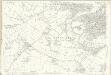
Shropshire XXXIV.10 (includes: Shrewsbury) - 25 Inch Map
1 : 2500 Topographic maps Ordnance Survey Ordnance Survey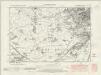
Shropshire XXXIV.SW - OS Six-Inch Map
1 : 10560 Topographic maps Ordnance Survey Ordnance Survey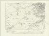
Shropshire XXXIV.SW - OS Six-Inch Map
1 : 10560 Topographic maps Ordnance Survey Ordnance Survey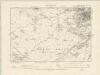
Shropshire XXXIV.SW - OS Six-Inch Map
1 : 10560 Topographic maps Ordnance Survey Ordnance Survey
Shropshire XXXIV.SW - OS Six-Inch Map
1 : 10560 Topographic maps Ordnance Survey Ordnance Survey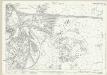
Shropshire XXXIV.11 (includes: Atcham; Shrewsbury) - 25 Inch Map
1 : 2500 Topographic maps Ordnance Survey Ordnance Survey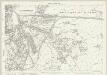
Shropshire XXXIV.11 (includes: Atcham; Shrewsbury) - 25 Inch Map
1 : 2500 Topographic maps Ordnance Survey Ordnance Survey
Shrewsbury (Hills) - OS One-Inch Revised New Series
1 : 63360 Topographic maps Ordnance Survey Ordnance Survey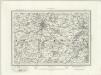
Shrewsbury (Outline) - OS One-Inch Revised New Series
1 : 63360 Topographic maps Ordnance Survey Ordnance Survey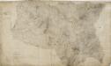
Shrewsbury
1 : 31680 The drawing of this,plan was,begun in 1817 and completed in 1827.,,Because of,many erasures and corrections, the drawing is cracked and dirty, and therefore hard to read. An area calculation table survives in black ink,in the,bottom left margin. Stevens, Henry
Actual survey of the county of Salop, 1
1 Blatt : 71 x 53 cm John Rocque
Actual Survey of the County of Salop
Rocque, John
Shrewsbury - OS One-Inch Map
1 : 63360 Topographic maps Ordnance Survey Ordnance Survey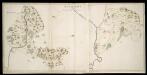
Map of Shropshire f.93
This is a manuscript map of Shropshire, one of four in the same style and hand. Its most interesting feature is the castle shown at Clun, which dominates the town. Other topographical features are limited to hills and trees, giving a general impression of the relief of the land and its coverage. It forms part of an atlas that belonged to William Cecil Lord Burghley, Elizabeth I's Secretary of State. Burghley used this atlas to illustrate domestic matters. Here Lord Burghley has added a place name adjacent the river, near to Lent Warden. Burghley was primarily interested in communication routes, an essential feature in any defence program for an area. Rivers were the most important of these communication routes as travel by water was often the fastest. Therefore a good knowledge of the locations along a particular river was essential for navigation and ultimately for the defence of the area. William Cecil, Lord Burghley
Shropshire, Sheet 17 - Bartholomew's "Half Inch to the Mile Maps" of England & Wales
1 : 126720 Topographic maps Bartholomew, John George John Bartholomew & Co
An accurate map of Shrop Shire
1 Karte : Kupferdruck ; 51 x 68 cm Bowen; Hinton sold by J. Hinton at the Kings Arms in St. Pauls Church Yard
Comitatvs Salopiensis; anglice Shrop Shire
1 Karte : Kupferdruck ; 37 x 48 cm Blaeu Joan Blaeu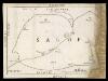
Map of Shropshire f. 75*
This is a manuscript map of Shropshire. It forms part of an atlat which belonged to Lord Burghley, Secretary of State to Elizabeth I, who used it to illustrate domestic matters. It shows only the principal towns, distinguishing between those with a castle and those without by means of a symbol of two connected towers with crenellations. The River Severn, marked Sabrina F, is charted. Lord Burghley has added a name adjacent to a place where the river is bridged. Lord Burghley was concerned with communication routes as revealed by his annotation. The draughtsman has indicated relief by hill symbols in two places. The map features a scale bar, but this is partly obscured by damage to the map.
Sheets 31-32. (Cary's England, Wales, and Scotland).
1 : 360000 Cary, John, ca. 1754-1835
South Wales and the border in the 14th century
Rees, William Ordnance Survey
COMITATVS | SALOPIENSIS; | Anglice | SHROP SHIRE.
[Amsterdam : Joan Blaeu]
STAFFORDIENSIS | COMITATVS; | Vulgo | STAFFORD SHIRE.
[Amsterdam : Joan Blaeu]
SALOPIAE COMITATUS f.86
This is a map of Shropshire by Christopher Saxton dating from 1577. It forms part of an atlas that belonged to William Cecil Lord Burghley, Elizabeth I’s Secretary of State. Burghley used this atlas to illustrate domestic matters. This map is actually a proof copy of one which forms part of Christopher Saxton’s Atlas of England and Wales. This atlas was first published as a whole in 1579. It consists of 35 coloured maps depicting the counties of England and Wales. The atlas is of great significance to British cartography as it set a standard of cartographic representation in Britain and the maps remained the basis for English county mapping, with few exceptions, until after 1750. During the reign of Elizabeth I, map use became more common, with many government matters referring to increasingly accurate maps with consistent scales and symbols, made possible by advances in surveying techniques. Illustrating the increasing use of maps in government matters, Lord Burghley, who had been determined to have England and Wales mapped in detail from the 1550s, selected the cartographer Christopher Saxton to produce a detailed and consistent survey of the country. The financier of the project was Thomas Seckford Master of Requests at the Court of Elizabeth I, whose arms appear, along with the royal crest, on each map. Burghley has annotated this map, adding several place names. The map was engraved by Remigius Hogenbergius, one of a team of seven English and Flemish engravers employed to produced the copper plates for the atlas. Saxton, Christopher Hogenbergius, Remigius
SALOPIAE COMITATUS Sheet 22
This map of Shropshireis from the 1583 edition of the Saxton atlas of England and Wales.This atlas was first published as a whole in 1579. It consists of 35 coloured maps depicting the counties of England and Wales. The atlas is of great significance to British cartography as it set a standard of cartographic representation in Britain and the maps remained the basis for English county mapping, with few exceptions, until after 1750. During the reign of Elizabeth I map use became more common, with many government matters referring to increasingly accurate maps with consistent scales and symbols, made possible by advances in surveying techniques. Illustrating the increasing used of maps in government matters, Lord Burghley, Elizabeth I’s Secretary of State, who had been determined to have England and Wales mapped in detail from the 1550s, selected the cartographer Christopher Saxton to produce a detailed and consistent survey of the country. The financier of the project was Thomas Seckford Master of Requests at the Court of Elizabeth I, whose arms appear, along with the royal crest, on each map. Saxton, Christopher Ryther, Augustine
A New and accurate map of Radnor Shire
1 : 237600