Maps of Worcestershire
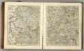
Sheets 31-32. (Cary's England, Wales, and Scotland).
1 : 360000 Cary, John, ca. 1754-1835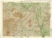
Shropshire, Sheet 17 - Bartholomew's "Half Inch to the Mile Maps" of England & Wales
1 : 126720 Topographic maps Bartholomew, John George John Bartholomew & Co
South Wales and the border in the 14th century
Rees, William Ordnance Survey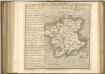

VIGORNIENSIS Comitatus Sheet 21
This map of Worcestershire is from the 1583 edition of the Saxton atlas of England and Wales.This atlas was first published as a whole in 1579. It consists of 35 coloured maps depicting the counties of England and Wales. The atlas is of great significance to British cartography as it set a standard of cartographic representation in Britain and the maps remained the basis for English county mapping, with few exceptions, until after 1750. During the reign of Elizabeth I map use became more common, with many government matters referring to increasingly accurate maps with consistent scales and symbols, made possible by advances in surveying techniques. Illustrating the increasing used of maps in government matters, Lord Burghley, Elizabeth I’s Secretary of State, who had been determined to have England and Wales mapped in detail from the 1550s, selected the cartographer Christopher Saxton to produce a detailed and consistent survey of the country. The financier of the project was Thomas Seckford Master of Requests at the Court of Elizabeth I, whose arms appear, along with the royal crest, on each map. Saxton, Christopher Ryther, Augustine
Wigorniensis comitatus et comitatus Warwicensis; nec non Coventræ libertas
1 Karte : Kupferdruck ; 40 x 48 cm Blaeu Joan Blaeu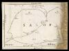
Map of Shropshire f. 75*
This is a manuscript map of Shropshire. It forms part of an atlat which belonged to Lord Burghley, Secretary of State to Elizabeth I, who used it to illustrate domestic matters. It shows only the principal towns, distinguishing between those with a castle and those without by means of a symbol of two connected towers with crenellations. The River Severn, marked Sabrina F, is charted. Lord Burghley has added a name adjacent to a place where the river is bridged. Lord Burghley was concerned with communication routes as revealed by his annotation. The draughtsman has indicated relief by hill symbols in two places. The map features a scale bar, but this is partly obscured by damage to the map.
An accurate map of the county of Worcester
1 Karte : Kupferdruck ; 51 x 68 cm Bowen; Tinney; Bowles; Sayer; Bowles; Bowles sold by I. Tinney at the Golden Lion and R. Sayer at the Golden Buck in Fleet street T. Bowles in St. Pauls Church Yard and I. Bowles and son at the Black Horse in Cornhill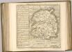

Wigorniensis Comitatus cum Warwicensi, nec non Conventriae Libertas
1 : 180000 Amstelodami : apud Joannem Janssonium
Ludlow - OS One-Inch Map
1 : 63360 Topographic maps Ordnance Survey Ordnance Survey
Kidderminster - OS One-Inch Map
1 : 63360 Topographic maps Ordnance Survey Ordnance Survey
Birmingham - OS One-Inch Map
1 : 63360 Topographic maps Ordnance Survey Ordnance Survey
An accurate map of Shrop Shire
1 Karte : Kupferdruck ; 51 x 68 cm Bowen; Hinton sold by J. Hinton at the Kings Arms in St. Pauls Church Yard
Comitatvs Salopiensis; anglice Shrop Shire
1 Karte : Kupferdruck ; 37 x 48 cm Blaeu Joan Blaeu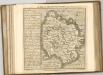
Bishop's Castle
1 : 31680 The River Clun Valley dominates the right-hand section of this plan of Shropshire. To the left is Clun Forest, famous for the sheep of the same name. The plan shows a section of the Offa's Dike running from top left towards bottom right. Extending 176 miles along the English border from the northern Welsh coast south to Chepstow,this great earth bank is eight miles longer than Hadrian's Wall. Unlike Hadrian's Wall, it was never garrisoned. Budgen, Thomas
Actual Survey of the County of Salop
Rocque, John
Actual survey of the county of Salop, 3
1 Blatt : 71 x 53 cm John Rocque
Ordnance Survey of England. Sheet 168, Birmingham
1 : 63360 Ordnance survey. GB Southampton : Ordnance Survey Office
Actual survey of the county of Salop, 4
1 Blatt : 71 x 53 cm John Rocque
Presteigne
1 : 31680 The Roman road, south to Hereford and beyond, runs across the Arrow Valley and Shobdon Marshes from top to bottom of this plan., At lower right, the River Arrow joins the River Lugg south of Leominster., The surrounding countryside appears intensively farmed., Throughout this region of Herefordshire,,based on rich red clay, farmland,dominates,in a,landscape of,well-hedged fields scattered,with small woods and threaded by,streams and brooks. Budgen, Thomas
Actual Survey of the County of Salop
Rocque, John
New map of the county of Hereford, 2
1 Blatt : 71 x 58 cm s.n.
New map of the county of Hereford, 1
1 Blatt : 71 x 58 cm s.n.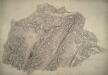
Much Wenlock
1 : 31680 This plan,of,part of East Shropshire is dominated by Wenlock Edge., Running from the bottom left of the drawing to the top right, this,heavily,wooded,limestone ridge,extends for 16 miles across Shropshire.,,It shelves steeply into the patchwork fields of Ape Dale on its,western face, and,slopes gently into the Corve Dale to the east., The remains of the ancient Long Forest are also noted. Stevens, Henry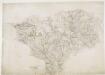
Bridgenorth
1 : 31680 This plan covers East Shropshire and part of Staffordshire, with the River Severn Valley depicted down the left side of the sheet. Here, in its middle course, the river becomes deeper and wider, forming a floodplain in which crops such as wheat and barley are grown. Down the right side of the plan is a section of the Staffordshire and Worcestershire Canal, built by the canal engineer, James Brindley as part of his 'Grand Cross', a farsighted scheme to link the ports of Hull, Liverpool and Bristol by connecting the rivers Mersey, Trent and Severn. The canal opened in May 1772. Ironbridge on the Severn at the top left of the plan is said to be the birthplace of the Industrial Revolution. This tiny town gave the world its first iron bridge in 1779. Dawson, Robert
Wolverhampton 10
1 : 31680 This plan covers part of the English Midland plateau. The Staffordshire and Worcestershire Canal is depicted down the left side. Opened for traffic in May 1772, the canal was built by engineer James Brindley as part of his 'Grand Cross', a far-sighted scheme to link the ports of Hull, Liverpool and Bristol by connecting the rivers Mersey, Trent and Severn. Work on a second waterway, the Birmingham Canal, started a year later to facilitate the transport of coal from the pits of the Black Country to Birmingham. The Industrial Revolution saw over 180 miles of canals and 216 locks built. Part of this network is visible on the plan highlighted in blue. Dawson, Robert
Cleobury Mortimer
1 : 31680 The two smooth humps of Brown Clee Hill dominate the landscape east of Ludlow. With its summit rising to 1,772 ft, Brown Clee is the highest point in Shropshire and was,an iron-age settlement, hosting three hillforts.,Below Brown Clee, the plan shows another isolated hill fort at Titterstone Clee.,At an altitude of,1,750 ft,,this fort is one of the highest and largest in Britain. , Stevens, Henry


