Maps of Portsmouth
Town of Portsmouth
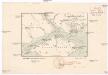
This is a map of Portsmouth, showing the old town and extending to cover Gosport. It dates from around 1552. The old town is shown in some detail, including the defences, buildings, streets, house plots and fields. The purpose of the plan seems to be to show the progress of the works that began in 1545 and finished in 1551. However, there are some differences between what this plan shows and what was eventually built. For example the bulwark adjacent to Guy’s Bastion appears here in a form that was not adopted. This suggests that the defences along the north-east wall show proposals and not completed works. The north east section of the plan is drawn in greater detail that other areas, supporting the idea that works here were still under consideration. Apart from Guy’s Bastion, the north-eastern defences were eventually built as this plan depicts, notably with a square bastion at the western end and an orillon -type bastion at the main gate. The exact date of the map is uncertain but it was drawn sometime between works commencing in 1545 and 1563 when the Town Quay was rebuilt in a manner different to that presented here. In 1552 Portsmouth saw the arrival of John Rogers, the military engineer who came to survey the town and also King Edward VI, who professed himself to be unhappy with the state of the defences and devised two strong castellis on either side of the Haven at the mouth thereof’. It is likely that this plan is connected with these visits as it combines existing features and also proposals for future works and therefore a date of the early 1550’s can be suggested.
Hampshire and Isle of Wight LXXXIII.11 (includes: Alverstoke; Portsmouth) - 25 Inch Map
1 : 2500 Topographic maps Ordnance Survey Ordnance Survey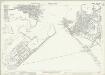
Hampshire and Isle of Wight LXXXIII.11 (includes: Alverstoke; Portsmouth) - 25 Inch Map
1 : 2500 Topographic maps Ordnance Survey Ordnance Survey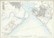
Hampshire and Isle of Wight LXXXIII.11 (includes: Alverstoke; Portsmouth) - 25 Inch Map
1 : 2500 Topographic maps Ordnance Survey Ordnance Survey
Hampshire and Isle of Wight LXXXIII.11 (includes: Alverstoke; Portsmouth) - 25 Inch Map
1 : 2500 Topographic maps Ordnance Survey Ordnance Survey
Plan of Portsmouth from 1545
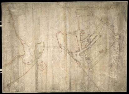
Although unremarkable in appearance this map of Portsmouth is of great significance in the context of the history of cartography. Dating from 1545 this plan is in fact the earliest map of any town in Britain to be drawn entirely to scale. Unlike many maps or plans of the period no attempts to show features of the town pictorially have been made, making this plan closer to what we now perceive as a plan than many of its contemporaries. Few parallel examples of plans of this date, drawn entirely to scale, exist anywhere else in Europe. The plan sets out proposals for improving the defences of the town after the events of July 19th whenthe French and English fleets met in Spithead, the Mary Rose was sunk and the French landed on the nearby Isle of Wight. The plan shows a transverse rampart and ditch which cuts off the north east section of the walled area cut off from the rest of the town. The idea of adding an angle-bastion of contemporary Italian type to the south east rampart is indicated in pencil. The alterations shown here were not carried out but the proposals are of importance none the less as they show the earliest scheme for fortifying an English town with a fully flanked bastion system in the Italian style.
Map of Portsmouth
1 : 10000 Portsmouth : by W.H. Charpentier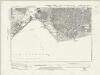
Hampshire & Isle of Wight LXXXIII.SE - OS Six-Inch Map
1 : 10560 Topographic maps Ordnance Survey Ordnance Survey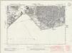
Hampshire & Isle of Wight LXXXIII.SE - OS Six-Inch Map
1 : 10560 Topographic maps Ordnance Survey Ordnance Survey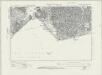
Hampshire & Isle of Wight LXXXIII.SE - OS Six-Inch Map
1 : 10560 Topographic maps Ordnance Survey Ordnance Survey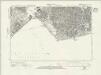
Hampshire & Isle of Wight LXXXIII.SE - OS Six-Inch Map
1 : 10560 Topographic maps Ordnance Survey Ordnance Survey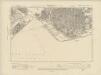
Hampshire & Isle of Wight LXXXIII.SE - OS Six-Inch Map
1 : 10560 Topographic maps Ordnance Survey Ordnance Survey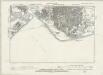
Hampshire & Isle of Wight LXXXIII.SE - OS Six-Inch Map
1 : 10560 Topographic maps Ordnance Survey Ordnance Survey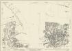
Hampshire and Isle of Wight LXXXIII.7 (includes: Alverstoke; Portsmouth) - 25 Inch Map
1 : 2500 Topographic maps Ordnance Survey Ordnance Survey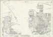
Hampshire and Isle of Wight LXXXIII.7 (includes: Alverstoke; Portsmouth) - 25 Inch Map
1 : 2500 Topographic maps Ordnance Survey Ordnance Survey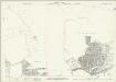
Hampshire and Isle of Wight LXXXIII.7 (includes: Alverstoke; Portsmouth) - 25 Inch Map
1 : 2500 Topographic maps Ordnance Survey Ordnance Survey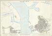
Hampshire and Isle of Wight LXXXIII.7 (includes: Alverstoke; Portsmouth) - 25 Inch Map
1 : 2500 Topographic maps Ordnance Survey Ordnance Survey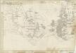
Hampshire & Isle of Wight LXXXIII - OS Six-Inch Map
1 : 10560 Topographic maps Ordnance Survey Ordnance Survey
Portsmouth
This drawing was surveyed in 1797, The year Napoleon declared that France "must destroy the English monarchy, Or expect itself to be destroyed by these intriguing and enterprising islanders. Let us concentrate all our efforts on the navy and annihilate England. That done, Europe is at our feet." The detail with which the area is surveyed reflects the danger the English establishment felt. The dockyards of Portsmouth, One of most important naval sites in Britain, Are shown by red blocks. The defence fortifications of the area are clearly delineated. South Sea Castle, One of the defensive forts built on the south coast by Henry VIII, Is shown in plan form.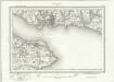
Portsmouth (Outline) - OS One-Inch Revised New Series
1 : 63360 Topographic maps Ordnance Survey Ordnance Survey
Portsmouth (Hills) - OS One-Inch Revised New Series
1 : 63360 Topographic maps Ordnance Survey Ordnance Survey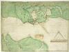
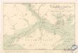
A coloured chart of Portsmouth Harbour, Spithead, and part of the Isle of Wight, on a scale of one mile to an inch
This is a map of Portsmouth and the Isle of Wight dating from 1585. It has been annotated by William Cecil Lord Burghley, Secretary of State to Elizabeth I, who has added the names "Westburhunt" and "Chichest". Burghley was an avid map collector and his application of geographical knowledge to matters of government is well known. Three beacons are indicated on 'Portesdowne', showing the systems in place for alerting the locality in an invasion scenario. Either side of these beacons are red windmill symbols named "westmyll" and "estmill", two further windmills, again highlighted in red, lie towards the centre of the map. It is likely that these have been highlighted due to their height which would facilitate their use as vantage points or beacons. There is a scale bar indicating a scale of one inch to a mile. Portsmouth became the focus of a new program of defensive works in 1584. Since the accession of the Protestant Elizabeth I to the English throne in 1558 Anglo-Spanish relationship had deteriorated. The continued English raids on Spanish colonial interests and England’s support of the Protestant rebellion in the Spanish ruled Netherlands had induced the Catholic Philip II to plan an invasion of England. It is likely that this map, detailing the beacons in the area, was produced for military purposes connected with the strengthening of the defences for the Portsmouth area against the expected Spanish Invasion. William Cecil, Lord Burghley
Map of the Isle of Wight
1 : 78000 Isle of Wight (Anglie) Edward Stanford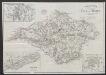
Bacon's new map of the Isle of Wight
1 : 63360 G.W. Bacon & Co.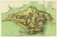
Wight[The Isle of]
Fowles, A.W. Ventnor
Map of Hampshire, including the Isle of Wight, 6
1 Blatt : 52 x 69 cm s.n.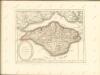
V anglickém průlivu