Maps of Swale

Content of the Manors of Bayford and Goodmanston, Kent
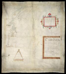
This is a map of the manors of Bayford and Goodmanston in Sittingbourne in Kent. It is by Christopher Saxton and dates from 1590. Saxton is perhaps most well known for his atlas of England and Wales, published in 1579 under the patronage of Elizabeth I. Christopher Saxton is first recorded in 1570 as an apprentice to John Rudd, Vicar of Dewsbury from 1554 to 1570,whose keen interest in cartography had seen him engaged in the 1550’s in making a platt’ of England. The period during which Saxton worked saw great advances in the field of cartography, particularly by the Dutch and Flemish. Saxton’s pioneering maps were made possible by advancements in draughtsmanship and surveying which emerged in part as a result of the practical needs of military engineers. By the 1540 military surveyors were well able to draft plans and topographical maps to scale. A large number of treatises on surveying appeared, responding to a desire to formalise land boundaries, military textbooks were published explaining the use of the cross-staff for surveying lengths and distances. These advances lead to the construction of increasingly sophisticated surveying instruments resulting in a new accuracy in mapping. Here a scale bar is includes, showing 64 perches to 4 inches. A perch is an old form of measurement equal to 16 and a half feet. Detail includes fields and houses, an orchard, roads and waterways. A cartouche encloses the acreages of lands within the manors. Orientation is given in the margins in Latin. Saxton, Christopher
Kent XXXIII.NW - OS Six-Inch Map
1 : 10560 Topographic maps Ordnance Survey Ordnance Survey
Kent XXXIII.NW - OS Six-Inch Map
1 : 10560 Topographic maps Ordnance Survey Ordnance Survey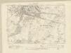
Kent XXXIII.NW - OS Six-Inch Map
1 : 10560 Topographic maps Ordnance Survey Ordnance Survey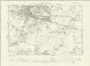
Kent XXXIII.NW - OS Six-Inch Map
1 : 10560 Topographic maps Ordnance Survey Ordnance Survey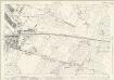
Kent XXXIII.2 (includes: Bapchild; Sittingbourne and Milton; Tonge) - 25 Inch Map
1 : 2500 Topographic maps Ordnance Survey Ordnance Survey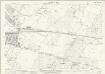
Kent XXXIII.2 (includes: Bapchild; Sittingbourne and Milton; Tonge) - 25 Inch Map
1 : 2500 Topographic maps Ordnance Survey Ordnance Survey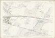
Kent XXXIII.2 (includes: Bapchild; Sittingbourne and Milton; Tonge) - 25 Inch Map
1 : 2500 Topographic maps Ordnance Survey Ordnance Survey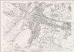
Kent XXXIII.1 (includes: Sittingbourne and Milton) - 25 Inch Map
1 : 2500 Topographic maps Ordnance Survey Ordnance Survey
Kent XXXIII.1 (includes: Sittingbourne and Milton) - 25 Inch Map
1 : 2500 Topographic maps Ordnance Survey Ordnance Survey
Kent XXXIII.1 (includes: Sittingbourne and Milton) - 25 Inch Map
1 : 2500 Topographic maps Ordnance Survey Ordnance Survey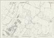
Kent XXI.14 (includes: Sittingbourne and Milton; Tonge) - 25 Inch Map
1 : 2500 Topographic maps Ordnance Survey Ordnance Survey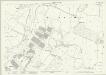
Kent XXI.14 (includes: Sittingbourne and Milton; Tonge) - 25 Inch Map
1 : 2500 Topographic maps Ordnance Survey Ordnance Survey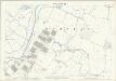
Kent XXI.14 (includes: Sittingbourne and Milton; Tonge) - 25 Inch Map
1 : 2500 Topographic maps Ordnance Survey Ordnance Survey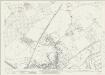
Kent XXI.13 (includes: Bobbing; Sittingbourne and Milton) - 25 Inch Map
1 : 2500 Topographic maps Ordnance Survey Ordnance Survey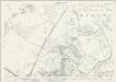
Kent XXI.13 (includes: Bobbing; Sittingbourne and Milton) - 25 Inch Map
1 : 2500 Topographic maps Ordnance Survey Ordnance Survey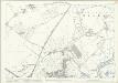
Kent XXI.13 (includes: Bobbing; Sittingbourne and Milton) - 25 Inch Map
1 : 2500 Topographic maps Ordnance Survey Ordnance Survey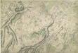
Sittingbourne, Kent
1 : 10560 This plan, showing the area around Sittingbourne in Kent, is drawn on rectangular sheet lines and enclosed by a black border. Fields are coloured brown where cultivated, and green or blank if untilled. Stonework buildings or structures are drawn in red ink at major settlements like Milton and Sittingbourne, at the centre top of the plan. Infilled or blocked areas of black or sepia ink depict structures or buildings made from impermanent materials such as wood. Corrections have been made on this plan and it is likely that the red-ink numerical annotations of altitude are measured rather than estimated or sketched.
Milton, Kent
1 : 10560 This original protraction of the Swale in Kent extends from Milton to Conyer Creek, and comprises the first plottings from the field book of the area. Ruled-black sheet lines indicate the edges of the area that were copied for the finished drawings OSD 112 and OSD 113. The plan is made up of two pieces of paper, irregularly cut and then joined together.
TQ96 - OS 1:25,000 Provisional Series Map
1 : 25000 Topographic maps Ordnance Survey Ordnance Survey
A topographical-map, of the county of Kent, 8
1 Blatt : 54 x 70 cm A. Dury, W. Herbert
A Map of the Isle of Sheppey
This map of the Isle of Sheppey dates from 1574 and is thought to be the work of the cartographer Robert Lythe.Lythewas a cartographer of note as he created the first accurate map of Ireland while under the employ of the Crown and is therefore comparable to Christopher Saxton in his importance in the context of the history of cartography. This map was created for the purposes of defence and also to solve the problem of drainage in the area. The emphasis on streams and waterways suggests a link with the repeated attempts to avoid the silting up of Sandwich Haven by increasing the amount of water it could hold. The works were to be financed by a local levy, hence perhaps the prominence of names which may be a guide to apportionment. Anglo-Spanish relations had been in steady decline since the accession of the protestant Elizabeth I in 1558. In 1574 there was a fear that the Spanish would launch an attack from the Netherlands on ships at Chatham. In the idea of transferring the main fleet to Queenborough was suggested as a precaution. Under the command of Sir William Winter, Surveyor of the Navy and Sir William Pelham, Lieutenant General of Ordnance, and Lythe a survey of Sheppey was carried out. Sheerness and the Isle of Grain were rejected in favour of a new port at Swaleness opposite Queenbrough which would prevent a raid from the rear by way of the Swale. Swaleness was a marsh and in order to build fortifications drainage and embanking or the area was necessary. This was authorised by the Privy Council in September 1574. Earthworks were created but the fortifications were not built and in the event the Spanish did not invade until 1588. Lythe, Robert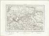
Chatham (Outline) - OS One-Inch Revised New Series
1 : 63360 Topographic maps Ordnance Survey Ordnance Survey
Chatham (Hills) - OS One-Inch Revised New Series
1 : 63360 Topographic maps Ordnance Survey Ordnance Survey
Chatham and Maidstone - OS One-Inch Map
1 : 63360 Topographic maps Ordnance Survey Ordnance Survey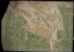
Mouths of the Thames and Medway from Ipswich to Sandwich and Maldon and Rochester to the Sea
This is a map showing the mouths of the Thames and the Medway from Ipswich to Sandwich and Maldon and Rochester to the sea. It dates from around 1544 and is annotated Rycherd Cavendishe made this carde’. Richard Cavendish was a master gunner who had supervised new defence works at Berwick and Wark in 1522-3. The map seems to have been made with the purposes of defence and navigation in mind. Coastal forts and navigational channels are shown. The shoreline is exaggerated in order to illustrate clearly how an enemy might move ashore and how they might be stopped. In this case the enemy was England’s ancient adversary France, with whom hostilities had resumed in 1542. This map of the vulnerable south east coast, was made against this historical background. The fear of a French invasion was very real. In 1514 the French had invaded Brighton, and in 1545 French ships entered the Solent and landed on the Isle of Wight. The lines which cover the sea areas of the map are called rhumb lines. These are lines of constant bearing that radiate from compass roses and allow the sailor to plot a course from harbour to harbour using dividers and straight edge. Vignettes of several towns are included on this map, Sandwich, Rochester and Canterbury are shown. The view of Essex is possibly derived from a survey Cavendish made in 1520. Other settlements are formalized showing rows of red roofed houses with a church in the centre. A scale bar annotated by 3’ is included, however, as this occupies a green painted area it is likely that this was added later. Cavendish, Richard
Kent, Sheet 31 - Bartholomew's "Half Inch to the Mile Maps" of England & Wales
1 : 126720 Topographic maps Bartholomew, John George John Bartholomew & Co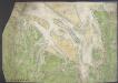
Chart of the mouth of the River Thames, c1540
This map, showing parts of Kent and Sussex, comes from a 16th-century portfolio of coastal charts and drawings It incorporates miniature copies of town plans that are now lost including what are probably the earliest plans of Canterbury, Rochester and Sandwich The mapmaker was Sir Richard Cavendish With its emphasis on sandbanks and beaches, the map was evidently intended for navigation and defence purposes The decorative quality of the map suggests it was meant for the eyes of the king, Henry VIII North is to the left of the map and East to the top, making the map appear on its side to modern eyes Cavendish, Sir Richard
60. London. The World Atlas.
1 : 250000 USSR (Union of Soviet Socialist Republics).