Maps of Rhode Island
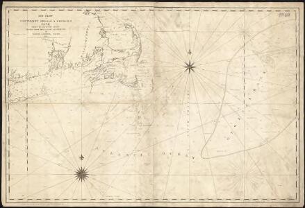
A new chart of Nantucket Shoals & George's Bank with the adjacent coast
1 : 490000 Lambert, Samuel Lambert, Samuel
The south part of New-England, as it is planted this yeare, 1635
1 : 990000 Wood, William Frank Gair, Macomber
Old Colony Railroad and connections
1 : 633600 Winslow, E. N [s.n.]
Providence
1 : 250000
Providence
1 : 250000
Providence
1 : 250000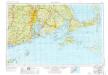
Providence
1 : 250000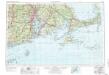
Providence
1 : 250000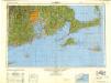
Providence
1 : 250000
An accurate map of Rhode Island, part of Connecticut and Massachusets, shewing Admiral Arbuthnot's station in blocking up Admiral Ternay

The state of Rhode Island
1 : 281600 Harris, Harding Mathew Carey
The State of Rhode Island. Compiled from the survey and observations of Caleb Harris.
from Carey's general atlas, improved and enlarged : being a collection of maps of the world and quarters, their principal empires, kingdoms, &c.
Map of the counties of Barnstable, Dukes and Nantucket, Massachusetts : based upon the trigonometrical survey of the state
1 : 63360 Walling, Henry Francis, 1825-1888 D.R. Smith & Co.
A chart of Nantucket shoals
1 : 145000 Pinkham, Paul, 1736-1799 Published & Sold by John Norman
Contents: Rhode Island atlas.
1 : 250000 Geological Survey (U.S.)
A geological map of Rhode-Island
1 : 190080 Jackson, Charles T. (Charles Thomas), 1805-1880 [s.n.]
A pilot's chart of Nantukket Shoals : from the last observations carefully compared and proved to be accurate
1 : 219400 Jones, Thomas [s.n.]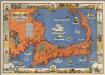
Cape Cod, Barnstable County, Mass. Inc. 1639. Drawn by C.W. Holliday
1 : 150000 Holliday, C.W.
A map of the state of Rhode Island / taken mainly from surveys by Caleb Harris ; Harding Harris, delineavt. ; Saml. Hill, sculpt
1 : 160000 Harris, Caleb Carter & Wilkinson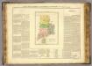
Rhode Island.
1 : 395000 Buchon, J. A. C.; Carey, H. C.; Lea, I.
Rhode Island.
1 : 475200 Scott, Joseph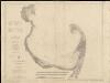
Cape Cod Bay, Massachusetts
1 : 80000 U.S. Coast and Geodetic Survey U.S. Coast and Geodetic Survey
Rhode Island.
1 : 420000 Arrowsmith, Aaron; Lewis, Samuel
Rhode Island.
1 : 420000 Lewis, Samuel
Rhode Island.
1 : 360000 Finley, Anthony
Rhode Island.
1 : 375000 Lucas, Fielding Jr.
Rhode Island.
1 : 360000 Tanner, Henry S.
Boston.
Shell Oil Company
Rhode Island.
1 : 463000 Lucas, Fielding Jr.
Rhode Island.
1 : 322000 Rand McNally and Company
Rhode Island.
1 : 290000 Goodrich, S.G.
Rhode Island.
1 : 290000 Bradford, Thomas G.
Rhode Island.
1 : 360000 Finley, Anthony
Rhode Island.
1 : 411840 Lucas, Fielding Jr.
Rhode Island.
1 : 496320 Henshaw, Frances A.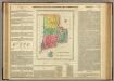
Map Of Rhode Island.
1 : 380160 Lea, I.
State of Rhode Island.
1 : 205920 Winterbotham, W.