Maps of Barnstable County

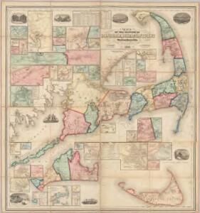
Map of the counties of Barnstable, Dukes and Nantucket, Massachusetts : based upon the trigonometrical survey of the state
1 : 63360 Walling, Henry Francis, 1825-1888 D.R. Smith & Co.
Cape Cod, Barnstable County, Mass. Inc. 1639. Drawn by C.W. Holliday
1 : 150000 Holliday, C.W.
Boston.
Shell Oil Company
Cape Cod Bay, Massachusetts
1 : 80000 U.S. Coast and Geodetic Survey U.S. Coast and Geodetic Survey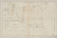
A chart of Nantucket shoals
1 : 145000 Pinkham, Paul, 1736-1799 Published & Sold by John Norman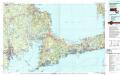
New Bedford
1 : 100000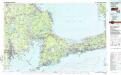
New Bedford
1 : 100000
Cape Cod Bay
1 : 80000 U.S. Coast and Geodetic Survey U.S. Coast and Geodetic Survey
A pilot's chart of Nantukket Shoals : from the last observations carefully compared and proved to be accurate
1 : 219400 Jones, Thomas [s.n.]
Martha's Vineyard : Dukes County, Massachusetts
1 : 85000 Tripp, B. Ashburton, 1887-1955
Map of the county of Plymouth, Massachusetts : from actual surveys
1 : 47520 Walling, Henry Francis, 1825-1888 D.R. Smith & Co.
From Monomoy and Nantucket Shoals to Muskeget Channel, Mass.
1 : 80000 U.S. Coast and Geodetic Survey U.S. Coast and Geodetic Survey
New Bedford
1 : 125000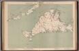
Massachusetts. Atlas Plate No. 11.
1 : 63360 Walker, O.W.
Gay Head quadrangle, Massachusetts
1 : 62500 Geological Survey (U.S.) U.S. Geological Survey
Yarmouth quadrangle, Massachusetts
1 : 62500 Geological Survey (U.S.) U.S. Geological Survey
Wellfleet quadrangle, Massachusetts
1 : 62500 Geological Survey (U.S.) U.S. Geological Survey
Falmouth quadrangle, Massachusetts
1 : 62500 Geological Survey (U.S.) U.S. Geological Survey
Martha's Vineyard quadrangle, Massachusetts
1 : 62500 Geological Survey (U.S.) U.S. Geological Survey
Barnstable quadrangle, Massachusetts
1 : 62500 Geological Survey (U.S.) U.S. Geological Survey
Muskeget quadrangle, Massachusetts
1 : 62500 Geological Survey (U.S.) U.S. Geological Survey
Plymouth quadrangle, Massachusetts
1 : 62500 Geological Survey (U.S.) U.S. Geological Survey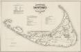
Historical map of Nantucket
1 : 126720 Ewer, Ferdinand C. (Ferdinand Cartwright), 1826-1883 The Major & Knapp Eng. Mfg. & Lith. Co.
Nantucket quadrangle, Massachusetts
1 : 62500 Geological Survey (U.S.) U.S. Geological Survey
Map of the town of Sandwich, Barnstable County, Mass. : surveyed by order of the town
Walling, Henry Francis, 1825-1888 Henry Walling & Co.
42. Gay Head sheet.
1 : 62500 Massachusetts. Topographical Survey Commission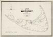
Map of the island of Nantucket : including Tuckernuck
1 : 40000 Mitchell, William, 1791-1868 E.W. Bouvé's drawing and lithography
Plymouth County.
1 : 158400 Gray, Ormando Willis; Walling, H. F.
New Bedford quadrangle, Massachusetts
1 : 62500 Geological Survey (U.S.) U.S. Geological Survey