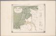
Maps of Netherlands

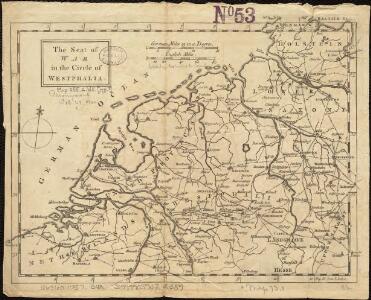
The seat of war in the circle of Westphalia
1 : 2543400
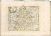
Holland und Berg
Allgemeiner Atlas [Walch, Johannes] im Verlag bei Johannes Walch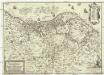
Nova et accurata XVII. Germaniae inferioris provinciarum delineatio et repraesentatio
1 : 860000 Nizozemsko I. H. S. Hipschmann, Sigmund Gabriel Johann Hofmann
La Hollande
1 : 650000 W.C. v. Baarsel del. et sculp. [S.l.] : J. R. Poster excudit
Foederatum Belgium Nec non Ducatus Bremensis ac etiam Pars Fluminis Albis Peraccurate correcta auctore
1 : 840000 Mollova mapová sbírka Allard, Carel
Summaria descriptio Fresiae Universae, cum latissime patuit nomen post emigrationem Francorum, Saxonumq. accessionem
auctore Mensone Alting Gerard de Broen fecit Amstelodami. [Amstelaedami] : [apud Henricum Wetstenium]
Nouvelle carte des departements de Hollande et des départemens circonvoisins de l'Empire Francais = Nieuwe kaart der departementen van Holland, en die der omliggende van het Fransche keizerrijk
1 : 760000 W.C. van Baarsel del. et sc. A Amsterdam : chez E. Maaskamp
Summaria Descriptio Fresiae Vniversae; cum latissimè patuit nomen Post emigrationem Francorvm; Saxonvmq; accessionem
1 : 1400000 Mollova mapová sbírka Alting, Menso Broen, Gerrit de
Carte de la république de France, 8
1 Blatt : 35 x 59 cm s.n.
Charte über die saemtlichen zum Westphaelischen Kreis gehörige Laender
1 : 834000 Vestfálsko (Německo) Güssefeld, Franz L. Homaenischen Erben
Holland.
1 : 1457280 Lucas, Fielding Jr.
Karte von Holland nach der letzten Gränz-Berichtigung verfasst
1 : 970000 Nizozemsko Tranq. Mollo
Accuratissima Rheni inferioris Mosae et Mosellae tabula ac minores in eosdem influentes fluvii
1 : 950000 1 Karte : Kupferdruck ; 49 x 57 cm Danckerts, Theodorus [Danckerts]
Holland.
1 : 1300000 Darton, William
Charte des Königreichs Holland
1 : 650000 Nizozemsko Stieler, Adolf Streit, Friedrich Wilhelm
Charte des Königreichs Holland
1 : 650000 Nizozemsko Stieler, Adolf Streit, Friedrich Wilhelm
Charte des Königreichs Holland
1 : 650000 Nizozemsko Stieler, Adolf Streit, Friedrich Wilhelm
CHARTE des KÖNIGREICHS HOLLAND
1 : 640000 Nizozemsko Stieler, Adolf Streit, Friedrich Wilhelm
Charte des Königreichs Holland
1 : 650000 Nizozemsko Stieler, Adolf Streit, Friedrich Wilhelm
Charte des Königreichs Holland
1 : 650000 Nizozemsko Stieler, Adolf Streit, Friedrich Wilhelm
Mappa geographica summo labore, accurate et novissime exarata, exhibens circulos aliquot Germaniae, praesertim illos ubi bellum nunc geritur
1 : 1300000 Nizozemsko Lotter, Tobias Conrad Tob. Conr. Lotter
Holland.
1 : 1300000 Lucas, Fielding Jr.
Oud Nederland zo als het zelve door de Batavieren, Marezaaten, Sturien, Frisiabonen ... en andere volkeren oudtijds bewoond wierd, naar de plaatsing der beste schrijveren.
1 : 3500000 Te Amsterdam : bij Arend Fokke Simonsz.
Descriptio Frisiae sub Francorum reditum qua hodie VII Foederator. est
1 : 950000 auctore Mensone Alting Ger. de Broen fec. Amstel. [Amstelaedami] : [apud Henricum Wetstenium]
Nieuwe aardrykskundige kaart van het Koningryk Holland in deszelfs geheel grondgebied met het voormalig Oost-Friesland, Jeverland, Kniphuisen en Varel
1 : 700000 naar de jongste Staats-verdragen door Jacob de Gelder A Zürcher sculp. Te Amsterdam : by Johs. Allart en Jacs. Ruis
Tabula Geographica qua Pars Septentrionalis sive Inferior Rheni, Mosae et Moselle
1 : 1100000 Mollova mapová sbírka Visscher, Nicolaes Jansz. Visscher, Nicolaus
Tabula Geographica qua Pars Septentrionalis sive Inferior Rheni, Mosae et Moselle
1 : 1100000 Mollova mapová sbírka Visscher, Nicolaes Jansz. Visscher, Nicolaus
Carte Generale d'Allemagne
1 : 1300000 Mollova mapová sbírka Eisenschmidt, Johann Caspar Julien, Roch Joseph