Maps of Malappuram

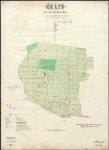
Map of the Codacal Church Fund Parapery Estate.
A. Paul
Malabar und die Nilagiri od. blaue Berge
Atlas der evangelischen Missions-Gesellschaft zu Basel Locher; Gross, Rudolf Im Verlag des Comptoires der evangelischen Missions-Gesellschaft
[Indian Atlas] Sheet 62

Mysore State (Vishal Karnatak)

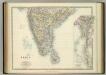
India II. Madras Presidency.
1 : 2200000 Society for the Diffusion of Useful Knowledge (Great Britain)
India 1.
1 : 2217600 Letts, Son & Co.
India I and Ceylon.
1 : 2200000 Society for the Diffusion of Useful Knowledge (Great Britain)
Map of the Malabar District

India 2.
1 : 2217600 Letts, Son & Co.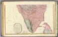
India peninsula S.
1 : 1300000 Faden, William, 1750?-1836
India I and Ceylon. Published under the Superintendence of the Society for the Diffusion of Useful Knowledge.

Ostindisches Missionsgebiet der evan.miss.gesellschaft in Basel
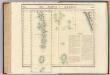
Iles Maldives et Laquedives. Asie 107.
1 : 1641836 Vandermaelen, Philippe, 1795-1869
Composite: India peninsula.
1 : 1300000 Faden, William, 1750?-1836

The Carnatic, Etc.
1 : 3380000 Sharpe, J.
The Southern Railway

Peninsula Indiæ citra Gangem, hoc est, orae celeberrimae Malabar & Coromandel cum adjacente insula non minus celebratissima Ceylon
1 Karte : Kupferdruck ; 53 x 47 cm L'Isle Homännische Erben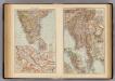
India South, Burma, Malay Peninsula.
1 : 6000000 Andree, Richard; Times (London, England)
Sheet D [South India], uit: Road map of India
1 : 2027520 titelvariant: North West India; Central & North India; North East India; South India; Annotatie geografische gegevens: De bladen overlappen elkaar gedeeltelijk; Elk blad met bladoverzicht van de hele serie [S.l. : India Tyre & Rubber Company]
S. Hindostan.
1 : 3000000 Thomson, John
India - southern section.
1 : 4000000 John Bartholomew & Co.
Peninsula Indiae citra Gangem hoc est orae celeberrimae Malabar & Coromandel cum adjacente insula non minus celebratissima Ceylon
1 : 3000000 Indie studio Homannianorum Heredum
Peninsula INDIAE citra Gangem, hoc est Orae celeberrimae MALABAR & COROMANDEL Cum adjacente Insula non minus celebratissima CEYLON
1 : 3000000 Ganga-oblast (Indie a Bangladéš) Delisle, Guillaume studio Homannianorum Heredum
Peninsula INDIAE citra Gangem hoc est Orae celeberrimae MALABAR & COROMANDEL Cum adjacente Insula non minus celebratissima CEYLON
1 : 3000000 Ganga-oblast (Indie a Bangladéš) Delisle, Guillaume studio Homannianorum Heredum
Charte der Provinz oder Audiencia von Lima oder des alten Königreichs Peru
Lima-oblast (Peru) Schmidt, Johann Marius Friedrich Franz
Carte des Côtes de Malabar et de Coromandel
1 : 3800000 presentée au Roy par [...] G. Delisle Amsterdam : chez Pierre Schenk, l'entr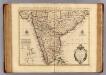
Malabar, Coromandel, cotes.
1 : 4000000 L'Isle, Guillaume de, 1675-1726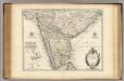
Malabar, Coromandel, costes.
1 : 4000000 L'Isle, Guillaume de, 1675-1726