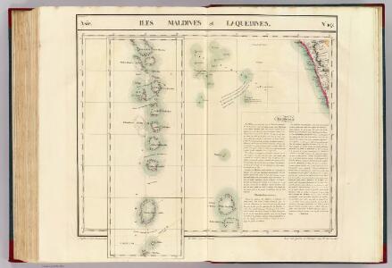
Maps of Maldive Islands
Iles Maldives et Laquedives. Asie 107.
1 : 1641836 Vandermaelen, Philippe, 1795-1869
Trigonometrical survey of the Maldive Islands
1 : 310000 Moresby, Robert Hydrographic Office
Arbeitsgebiet der Basler Missions Station Calicut
G. Peter
Map of the Codacal Church Fund Parapery Estate.
A. Paul
Map of the Basel German Evangelical Mission Committee's Nettoor Compound.
Eckelmann, O.
Ground plan of the new Tellichery compound.
Eckelmann, O.
Charte der Provinz oder Audiencia von Lima oder des alten Königreichs Peru
Lima-oblast (Peru) Schmidt, Johann Marius Friedrich Franz
India peninsula S.
1 : 1300000 Faden, William, 1750?-1836
Map of the Malabar District

Malabar und die Nilagiri od. blaue Berge
Atlas der evangelischen Missions-Gesellschaft zu Basel Locher; Gross, Rudolf Im Verlag des Comptoires der evangelischen Missions-Gesellschaft
Indes II.
1 : 10000000 Bonne, Rigobert, 1727-1794
Hind, Hindoostan, or India.
1 : 5650000 Faden, William, 1750?-1836
Hind, Hindoostan or India
A new general atlas of modern geography, consisting of a complete collection of maps of the four quarters of the globe Wyld, James James Wyld
CHARTE von OST-INDIEN diesseits des Ganges oder HINDOSTAN und DEKAN
1 : 10800000 Ganga-oblast (Indie a Bangladéš)
Charte von Ost-Indien diesseits des Ganges oder Hindostan und Dekan
1 : 11000000 Hindustán (Indie)
Vorder Indien.
1 : 6100000 Weiland, C. F. (Carl Ferdinand), d. 1847
Carte d'une partie des Indes orientales, estats du Mogol les côtes de Malabar et de Coromandel &c
1 : 14000000 Himálaj-oblast par Cóvens et Mortier
Ad antiquam Indiae geographiam tabula.
1 : 11300000 Anville, Jean Baptiste Bourguignon d, 1697-1782
Carte Generale des Indies.
1 : 9500000 Vivien de St Martin, L.
Carte de l'Indostan servant à indiquer les possessions françaises en Asie
1 : 10000000 par A.M. Perrot gravé par les frères Malo Paris : Duprat-Duverger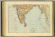
India South.
1 : 5448960 Stanford, Edward
Vorder-Indien
Neuer Handatlas über alle Theile der Erde Kiepert, Heinrich Verlag von Dietrich Reimer
Asia (Southern sheet).
1 : 14606000 Fisher, Richard Swainson
Vorder - Indien
Prémière partie de la carte d'Asie : contenant la Turquie, l'Arabie, la Perse, l'Inde en deçu du Gange et de la Tartarie ce qui est limitrophe de la Perse et de l'Inde / par le Sr. d'Anville ; gravé par Guill. de-la-Haye
1 : 6650000 Annotatie: In: [Atlas du Sr. d'Anville], bl. 1 Anville, Jean Baptiste Bourguignon d'; Haye, Guill. de la A Paris : chez l'auteur
Hindostan.
1 : 12600000 Greenleaf, Jeremiah
Hindostan.
1 : 12600000 Greenleaf, Jeremiah
Hindostan.
1 : 12672000 Burr, David H., 1803-1875