Maps of Atlas Mountains

Aphrica Tabula I. [Karte], in: Geographia universalis vetus et nova complectens Claudii Ptolemaei Alexandrini enarrationis libros VIII, S. 254.
1 Karte aus Atlas Münster, Sebastian [und Ptolemaeus, Claudius]
Tabula Prima Africae. [Karte], in: Claudii Ptolemei viri Alexandrini mathematice discipline philosophi doctissimi geographie opus [...], S. 181.
1 Karte aus Atlas Waldseemüller, Martin [und Ptolemaeus, Claudius] Übelin, Georg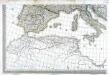
Carte d'Europe ou sont tracées les limites des empires, royaumes, et etats souverains, feuille 5
1 Blatt : 56 x 87 cm Semen etc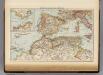
Mediterranean Sea W.
1 : 9000000 Andree, Richard; Times (London, England)
Mittelmeerlander westliche.
1 : 9000000 Andree, Richard
[Quator Affrice tabula] [Karte], in: Clavdii Ptholomei Viri Alexandrini Cosmographie, S. 158.
1 Karte aus Atlas Nicolaus Germanus [und Ptolemaeus, Claudius]
Afrique Septentrionale, Malte, Acores, Madere, Canaries.
1 : 7500000 Garnier, F. A., 1803-1863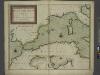
A new chart of the coast of the MEDITERRANEAN SEA
from The sea-atlas : containing an hydrographical description of most of the sea-coasts of the known parts of the world.
In notitiam ecclesiasticam Africæ tabula geographica
1 : 5700000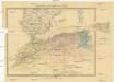
Marocco, Algerien und Tunis
1 : 6000000 Afrika severní Hochdanz, Emil Leo Woerl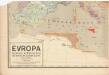
Evropa raného středověku: do konce VI. století po Kr.
Kašpar, Jan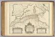
Africae Tabula Geographica.
1 : 4500000 L'Isle, Guillaume de, 1675-1726
Ancient Africa or Libya I.
1 : 5730000 Society for the Diffusion of Useful Knowledge (Great Britain)
La mer Mediterranée vers l'occident
1 Karte : Kupferdruck ; 38 x 49 cm Duval P. Duval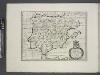
Spain, or Celtiberia.
from A new sett of maps both of antient and present geography : wherein not only the latitude and longitude of many places are corrected according to the latest observations, but also the most remarkable differences of antient and present geography may be quickly discern'd by a bare inspection or comparing of correspondent maps, which seems to be the most natural and easy method to lead young students (for whose use the work is principally intended) unto a competent knowledge of the geographical science : together with a geographical treatise particularly adapted to the use and design of these maps / by Edward Wells, M.A. and student of Christ-Church, Oxon.
Africae tabula geographica.
1 : 5700000 L'Isle, Guillaume de, 1675-1726

In notitiam ecclesiasticam Africae tabula geographica
1 : 4500000 L'Isle, Guillaume de, 1675-1726 Apud Auctorem, Via vulgo dicta des Canettes propè Sancti Sulpitii fanum
Nord-Africa Berberei
1 : 9678000 Afrika severní Schlieben Gleditsch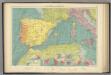
W. Mediterranean.
1 : 5000000 Philip, George
Tabula Europae II. [Karte], in: Claud. Ptolemaeus. Geographia lat. cum mappis [...], S. 257.
1 Karte aus Atlas Münster, Sebastian [und Ptolemaeus, Claudius]
North Africa or Barbary : Marocco
1 : 2800000 Society for the Diffusion of Useful Knowledge (Great Britain) George Cox
North Africa or Barbary : Tripoli
1 : 2000000 Society for the Diffusion of Useful Knowledge (Great Britain) George Cox
North Africa or Barbary : Algier
1 : 2000000 Society for the Diffusion of Useful Knowledge (Great Britain) George Cox
North Africa or Barbary : Parts of Tripoli and Egypt
1 : 2000000 Society for the Diffusion of Useful Knowledge (Great Britain) George Cox
North Africa or Barbary : Tunis and part of Tripoli
1 : 2000000 Society for the Diffusion of Useful Knowledge (Great Britain) George Cox
Partie occidentale de la mer Méditerranée
1 Karte : Kupferdruck ; 49 x 55 cm Robert de Vaugondy Didier Robert de Vaugondy
Hispania, Mauretania et Africa.
1 : 5000000 Kiepert, Heinrich, 1818-1899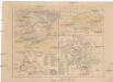
Hispania
Kartágo (zaniklé město)
![Aphrica Tabula I. [Karte], in: Geographia universalis vetus et nova complectens Claudii Ptolemaei Alexandrini enarrationis libros VIII, S. 254.](https://images-2.georeferencer.com/images/iiif/075806754173/full/,300/0/native.jpg)

