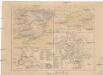
Maps of Atlas Mountains

Partie occidentale de la mer Méditerranée
1 Karte : Kupferdruck ; 49 x 55 cm Robert de Vaugondy Didier Robert de Vaugondy
Spain and Portugal.
from New & accurate description of the earth in all its empires, kingdoms and states
La mer Mediterranée vers l'occident
1 Karte : Kupferdruck ; 38 x 49 cm Duval P. Duval
Western part of the mediterranean sea with the coasts of Spain France Italy Barbary
1 Blatt : 53 x 68 cm Sayer
Europa befolkningskarta
A new chart of the coast of the MEDITERRANEAN SEA
from The sea-atlas : containing an hydrographical description of most of the sea-coasts of the known parts of the world.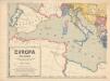
Evropa XIX. století: od vídeňského kongresu r. 1815, do rozhodnutí na frontách světové války r. 1918
Kašpar, Jan
Orbis Romani pars occidentalis
1 : 10600000 Evropa západní Anville, Jean-Baptiste Bourguinon d' Küffner, Paul in officina Weigelia-Schneideriana
Imperii Romani.
1 : 9850000 Vivien de St Martin, L.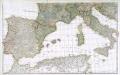
Prémière partie de la carte d'Europe contenant la France, l'Alemagne, l'Italie, l'Espagne & les isles britanniq.s, 2
1 Blatt : 53 x 85 cm s.n.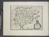
Spain, or Celtiberia.
from A new sett of maps both of antient and present geography : wherein not only the latitude and longitude of many places are corrected according to the latest observations, but also the most remarkable differences of antient and present geography may be quickly discern'd by a bare inspection or comparing of correspondent maps, which seems to be the most natural and easy method to lead young students (for whose use the work is principally intended) unto a competent knowledge of the geographical science : together with a geographical treatise particularly adapted to the use and design of these maps / by Edward Wells, M.A. and student of Christ-Church, Oxon.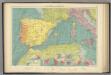
W. Mediterranean.
1 : 5000000 Philip, George
Orbis Romani, occidentalis.
1 : 11500000 Anville, Jean Baptiste Bourguignon d, 1697-1782; M'Dermut, Robert

Atlas für Handel und Industrie: Für Kaufleute, Fabrikante u. Gewerbetreibende, Handlungs- u. Gewerbe-Schulen

Das Mittelländische Meer
Stieler's Hand-Atlas Stieler, Adolf bei Justus Perthes
[133][136] Occidentalior tractus Maris Mediterranei, uit: Atlas sive Descriptio terrarum orbis
Annotatie: Gedigitaliseerde versie. Amsterdam. Heiloo : Picturae (vervaardiger), 2015. tiff-bestand. Gedigitaliseerd: 07-01-2015; Origineel: Universiteitsbibliotheek Vrije Universiteit (XL.05127.-) ; Netherlands; Titelpagina ontbreekt Wit, Frederik de Amsterdam : Frederick de Wit
Imperium Romanum
1 : 11100000 Evropa západní Bonne, Rigobert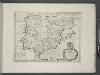
Spain and Portugal.
from A new sett of maps both of antient and present geography : wherein not only the latitude and longitude of many places are corrected according to the latest observations, but also the most remarkable differences of antient and present geography may be quickly discern'd by a bare inspection or comparing of correspondent maps, which seems to be the most natural and easy method to lead young students (for whose use the work is principally intended) unto a competent knowledge of the geographical science : together with a geographical treatise particularly adapted to the use and design of these maps / by Edward Wells, M.A. and student of Christ-Church, Oxon.
Nordwestliches Africa
Neuer Handatlas über alle Theile der Erde Kiepert, Heinrich Verlag von Dietrich Reimer
Das Mittellandische Meer Und Nord-Afrika.
1 : 7500000 Petermann, A.
Mare Mediterraneum
1 Karte : Kupferdruck ; 48 x 56 cm Seutter Matthäus Seutter
Ooster Deel der Middelandsche Zee [Karte] [Bona.] [Saragoßa.] [C. Carbonera] [Baya de Agde in Languedoq.] [Alcol] [P. Farina.] [Susa.] [Alzyra.] [8 Nebenkarten], in: De Nieuwe Groote Vermeerderde Zee-Atlas ofte Water-Werelt, S. 51.
1 Karte aus Atlas Doncker, Hendrick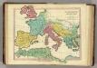
Patriarchati Occidentalis. (1826)
1 : 12100000 Tanner, Henry S.

Orbis Romani, pars occidentalis.
1 : 4300000 Anville, Jean Baptiste Bourguignon d, 1697-1782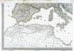
Carte d'Europe ou sont tracées les limites des empires, royaumes, et etats souverains, feuille 5
1 Blatt : 56 x 87 cm Semen etc
Orbis Romani pars occidentalis
1 : 10000000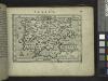
Spain.
from Abraham Ortelius his epitome of the theater of the worlde / nowe latlye ... renewed and augmented ... by Micheal Coignet, mathematitian of Antwarpe.