Maps of Atlas Mountains

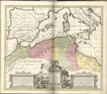
Africae Tabula Geographica.
1 : 4500000 L'Isle, Guillaume de, 1675-1726
In notitiam ecclesiasticam Africae tabula geographica
1 : 4500000 L'Isle, Guillaume de, 1675-1726 Apud Auctorem, Via vulgo dicta des Canettes propè Sancti Sulpitii fanum
In notitiam ecclesiasticam Africæ tabula geographica
1 : 5700000
Africae tabula geographica.
1 : 5700000 L'Isle, Guillaume de, 1675-1726
Hispania
Kartágo (zaniklé město)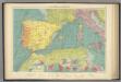
W. Mediterranean.
1 : 5000000 Philip, George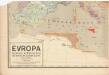
Evropa raného středověku: do konce VI. století po Kr.
Kašpar, Jan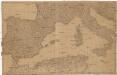
[Spanien und Italien]
Itálie Adam, Jakob
Pascaarte Van't westlyckste deel vande Middelandsche-Zee [...] [Karte], in: Het vijfde Deel Des Grooten Atlas : Vervatende De Water-Weereld, S. 187.
1 Karte aus Atlas Jansson, Jan Jansson, Jan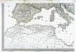
Carte d'Europe ou sont tracées les limites des empires, royaumes, et etats souverains, feuille 5
1 Blatt : 56 x 87 cm Semen etc
Paskaert van 't westelycke deel der Middelandsche Zee
1 Karte : Kupferdruck ; 41 x 51 cm Doncker by Hendrick Doncker boekverkoper en graadbooghmaker inde Nieuwbrugsteegh in 't Stuurmans gereedschap
Tabula Prima Africae. [Karte], in: Claudii Ptolemei viri Alexandrini mathematice discipline philosophi doctissimi geographie opus [...], S. 181.
1 Karte aus Atlas Waldseemüller, Martin [und Ptolemaeus, Claudius] Übelin, Georg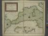
A new chart of the coast of the MEDITERRANEAN SEA
from The sea-atlas : containing an hydrographical description of most of the sea-coasts of the known parts of the world.
Pascaarte Van 't westlyckste deel vande Middelandsche-Zee [...] [Karte], in: Novus atlas absolutissimus, Bd. 9, S. 253.
1 Karte aus Atlas Janssonius Offizin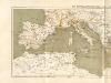
Atlas für Industrie- und Handelsgeographie: Für commercielle und technische Lehranstalten, für Kaufleute und Industrielle
Prémière partie de la carte d'Europe contenant la France, l'Alemagne, l'Italie, l'Espagne & les isles britanniq.s, 2
1 Blatt : 53 x 85 cm s.n.
Atlas für Handel und Industrie: Für Kaufleute, Fabrikante u. Gewerbetreibende, Handlungs- u. Gewerbe-Schulen

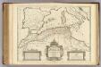
Occidentalior tractus Maris Mediterranei
1 Karte : Kupferdruck ; 47 x 56 cm Renard apud L. Renard
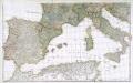
Partie occidentale de la mer Méditerranée
1 Karte : Kupferdruck ; 49 x 55 cm Robert de Vaugondy Didier Robert de Vaugondy
[133][136] Occidentalior tractus Maris Mediterranei, uit: Atlas sive Descriptio terrarum orbis
Annotatie: Gedigitaliseerde versie. Amsterdam. Heiloo : Picturae (vervaardiger), 2015. tiff-bestand. Gedigitaliseerd: 07-01-2015; Origineel: Universiteitsbibliotheek Vrije Universiteit (XL.05127.-) ; Netherlands; Titelpagina ontbreekt Wit, Frederik de Amsterdam : Frederick de Wit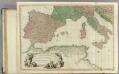
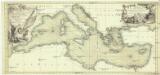
Mediterranean W.
1 : 2850000 Faden, William, 1750?-1836
La mer Mediterranée vers l'occident
1 Karte : Kupferdruck ; 38 x 49 cm Duval P. Duval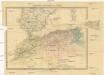
Marocco, Algerien und Tunis
1 : 6000000 Afrika severní Hochdanz, Emil Leo Woerl
Western part of the mediterranean sea with the coasts of Spain France Italy Barbary
1 Blatt : 53 x 68 cm Sayer
Aphricae Tabula II. [Karte], in: Claud. Ptolemaeus. Geographia lat. cum mappis [...], S. 287.
1 Karte aus Atlas Münster, Sebastian [und Ptolemaeus, Claudius]
Ooster Deel der Middelandsche Zee [Karte] [Bona.] [Saragoßa.] [C. Carbonera] [Baya de Agde in Languedoq.] [Alcol] [P. Farina.] [Susa.] [Alzyra.] [8 Nebenkarten], in: De Nieuwe Groote Vermeerderde Zee-Atlas ofte Water-Werelt, S. 51.
1 Karte aus Atlas Doncker, Hendrick
Aphrica Tabula I. [Karte], in: Geographia universalis vetus et nova complectens Claudii Ptolemaei Alexandrini enarrationis libros VIII, S. 254.
1 Karte aus Atlas Münster, Sebastian [und Ptolemaeus, Claudius]
Hispania, Mauretania et Africa.
1 : 5000000 Kiepert, Heinrich, 1818-1899