Maps of Sevilla

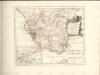
Hispalensis Conventus Delineatio [Karte], in: Theatrum orbis terrarum, S. 54.
1 Karte aus Atlas Ortelius, Abraham
Hispalensis Conventus Delineatio [Karte], in: Theatrum orbis terrarum, S. 101.
1 Karte aus Atlas Ortelius, Abraham Vrients, Jan Baptista
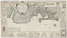
Mapa del reyno de Sevilla
1 Karte auf 4 Blättern : Kupferdruck ; 74 x 71 cm López; Ellobet s.n.
Sevilla regnum in suas archiepiscopatos episcopatos et praefecturas divisum
1 Karte : Kupferdruck ; 42 x 55 cm Güssefeld; López; Ellobet; Hauer Homännische Erben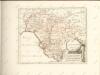
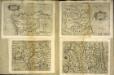
Hispalensis conventvs delineatio
1 Karte : Kupferdruck ; 14 x 18 cm Lambert Andreae
Hispalensis conventvs delineatio
1 Karte : Kupferdruck ; 33 x 43 cm Chaves; Ortelius s.n.
Li regni di Granata è d'Andalvcia / G. Cantelli da Vignola, 1
1 Blatt : Domenico de Rossi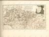

Mappa ou carta geographica dos reinos de Portugal e Algarve, 6
1 Blatt : 55 x 44 cm Dury
Mapa del Reyno de Cordova
1 : 500000 por Thomas Lopez, pensionista de S. M. C. Madrid : [Thomas Lopez]
Cordova
Córdoba-oblast (Španělsko)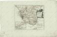
Des Koenigreichs Sevilla...

[Cádiz a okolí]
Andalusie (Španělsko)
Mapa del Reyno de Granada construido sobre las mejores y mas modernas memorias
1 : 570000 por Thomàs Lopez, pensionista de S. M. Madrid : [Thomas Lopez]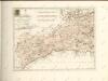
Plan de la baye et ville de Cadis de la riviere de St. Lucas de Barameda de ses environs
Beaurain
A plan of the city of Cadis and the environs, with the harbour, bay and soundings at lon water also a particular plan of the town and fortifications, from the collection of Capt. Clarck and improved by the late John Rocque, topographer to his Majesty
Rocque, John ; Clarck, capt.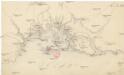
[Cádiz a okolí]
Andalusie (Španělsko)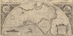
Hanc Insulam Perlustrabat [...] [Cadiz und Küste] [Karte], in: Theatrum orbis terrarum, S. 107.
1 Karte aus Atlas Ortelius, Abraham Vrients, Jan Baptista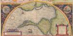
Hanc Insulam Perlustrabat [... Cadiz und Küste] [Karte], in: Theatrum orbis terrarum, S. 60.
1 Karte aus Atlas Ortelius, Abraham
The harbour of Cadiz
Smyth, W.H.
Nieuwen afteekening van de baij van Cadix
Spain Gerard van Keulen
Nieuwen afteekening van de baij van Cadix
Spain Gerard van Keulen
INSULA | GADITANA, | Vulgo | ISLA DE CADIZ.
Excud. Joannes Blaeu Amstelodami.
Insula Gaditana, vulgo Isla de Cadiz / [Joannes Blaeu]
1 : 100000 Annotatie: Oorspr. verschenen in: Geographiae Blavianae volumen nonum ... - Amstelaedani : Ioannis Blaeu, 1662; Origineel is Blad 7 in atlas factice Blaeu, Joan Amstelodami : excud. Joannes Blaeu
Insula Gaditana vulgo Isla de Cadiz
1 Plan : Kupferdruck ; 20 x 27 cm Allard; Allard by J. Covens et C. Mortier
Plan der Bay von Cadiz
Cádiz (Španělsko)
Plan der Bay von Cadiz
Cádiz (Španělsko)
![Hispalensis Conventus Delineatio [Karte], in: Theatrum orbis terrarum, S. 54.](https://images-2.georeferencer.com/images/iiif/659491284327/full/,300/0/native.jpg)

