Maps of Huelva

Mappa ou carta geographica dos reinos de Portugal e Algarve, 6
1 Blatt : 55 x 44 cm Dury
Mapa del reyno de Sevilla
1 Karte auf 4 Blättern : Kupferdruck ; 74 x 71 cm López; Ellobet s.n.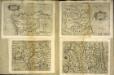
Hispalensis conventvs delineatio
1 Karte : Kupferdruck ; 14 x 18 cm Lambert Andreae
Hispalensis conventvs delineatio
1 Karte : Kupferdruck ; 33 x 43 cm Chaves; Ortelius s.n.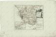
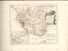
Des Koenigreichs Sevilla...
Carte du détroit de Gibraltar
1 Karte : Kupferdruck ; 56 x 87 cm Bellin s.n.
Castellum Gibraltar in Andalusia situm
1 Karte : Kupferdruck ; 26 x 32 cm, Bildgrösse 48 x 59 cm Lotter T. K. Lotter
Gibralter door de marquies d'villa Davias belegert
Gibraltar Schenk, Pieter P. Schenk
Die Meerenge von Gibraltar
1 Karte : Kupferdruck ; 20 x 17 cm Kellner s.n.
Mapa topographico de los payses, y costas, que forman el estrecho de Gibraltar
1 Karte : Kupferdruck ; 34 x 34 cm López s.n.
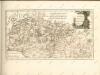
[Cádiz a okolí]
Andalusie (Španělsko)
Die Meerenge von Gibraltar
Hand-Atlas über alle Theile der Erde und über das Weltgebäude Stieler, Adolf Justus Perthes
Accurate Vorstellung der berühmten Meers-Enge bey Gibraltar
1 Karte : Kupferdruck ; 32 x 25 cm, Bildgrösse 47 x 56 cm Homännische Erben
Plan de la ville de Ceuta
1 Plan : Kupferdruck ; 33 x 14 cm, Bildgrösse 35 x 46 cm Longchamps; Longchamps chez le S.r Longchamps géographe rue des Cholets à l'enseigne de la place des Victoires
Mapa topographico de los payses, y costas, que forman el estrecho de Gibraltar : con quatro tablas, para saber por los dias de la luna, las horas, y los minutos de las mareas, flujo, y reflujo de este estrecho extraordinarias de los otros mares, con algunas observaciones sobre sus corrientes, sacado de varias. memorias impresas y manuscriptas
1 : 200000 por D. Thomás Lopez, pensionista de S. M. Madrid : [Thomas Lopez]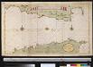
Het Naauw van de Middelandse Zee of Straat van Gibralter int groodt
Spain Gerard van Keulen
Carte topographique des pays et côtes maritimes qui forment le détroit de Gibraltar
1 Karte : Kupferdruck ; 42 x 40 cm, Bildgrösse 42 x 57 cm Homännische Erben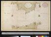
Nieuwe afteekeningh van de Straat van Gibralter van C. Tralfagar tot Gibralter
Spain Laurent Brémond Gerard van Keulen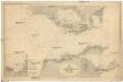
N-Atlantischer Ozean
1 : 100000 Atlantský oceán Reichs-Marine-Amt
Castellum Gibraltar
1 : 470000 Gibraltar Lotter, Tobias Conrad sumptibus Tobiae Conradi Lotter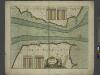
A chart of the STRAITS of GIBRALTER
from The sea-atlas : containing an hydrographical description of most of the sea-coasts of the known parts of the world.
Mapa del norte de Marruecos
1 : 100000 1 full d'1 mapa en 12 fulls entelats de 2 en 2 fulls dins d'un estoig. Datat entre 1920 i 1930. [Cuerpo de Estado Mayor del Ejército?]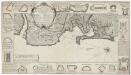
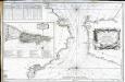
Plan de la baye et ville de Cadis de la riviere de St. Lucas de Barameda de ses environs
Beaurain
A plan of the city of Cadis and the environs, with the harbour, bay and soundings at lon water also a particular plan of the town and fortifications, from the collection of Capt. Clarck and improved by the late John Rocque, topographer to his Majesty
Rocque, John ; Clarck, capt.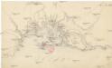
[Cádiz a okolí]
Andalusie (Španělsko)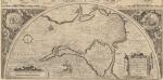
Hanc Insulam Perlustrabat [...] [Cadiz und Küste] [Karte], in: Theatrum orbis terrarum, S. 107.
1 Karte aus Atlas Ortelius, Abraham Vrients, Jan Baptista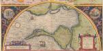
Hanc Insulam Perlustrabat [... Cadiz und Küste] [Karte], in: Theatrum orbis terrarum, S. 60.
1 Karte aus Atlas Ortelius, Abraham


