Maps of Sevilla

Hispalensis Conventus Delineatio [Karte], in: Theatrum orbis terrarum, S. 101.
1 Karte aus Atlas Ortelius, Abraham Vrients, Jan Baptista
Hispalensis Conventus Delineatio [Karte], in: Theatrum orbis terrarum, S. 54.
1 Karte aus Atlas Ortelius, Abraham
Mapa del reyno de Sevilla
1 Karte auf 4 Blättern : Kupferdruck ; 74 x 71 cm López; Ellobet s.n.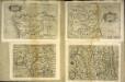
Hispalensis conventvs delineatio
1 Karte : Kupferdruck ; 14 x 18 cm Lambert Andreae
Hispalensis conventvs delineatio
1 Karte : Kupferdruck ; 33 x 43 cm Chaves; Ortelius s.n.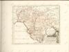

Sevilla regnum in suas archiepiscopatos episcopatos et praefecturas divisum
1 Karte : Kupferdruck ; 42 x 55 cm Güssefeld; López; Ellobet; Hauer Homännische Erben
Li regni di Granata è d'Andalvcia / G. Cantelli da Vignola, 1
1 Blatt : Domenico de Rossi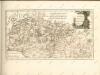

Mappa ou carta geographica dos reinos de Portugal e Algarve, 6
1 Blatt : 55 x 44 cm Dury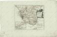
Des Koenigreichs Sevilla...

Cordova
Córdoba-oblast (Španělsko)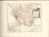

[Cádiz a okolí]
Andalusie (Španělsko)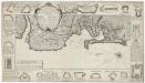
Plan de la baye et ville de Cadis de la riviere de St. Lucas de Barameda de ses environs
Beaurain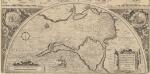
Hanc Insulam Perlustrabat [...] [Cadiz und Küste] [Karte], in: Theatrum orbis terrarum, S. 107.
1 Karte aus Atlas Ortelius, Abraham Vrients, Jan Baptista
The harbour of Cadiz
Smyth, W.H.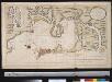
Nieuwen afteekening van de baij van Cadix
Spain Gerard van Keulen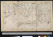
Nieuwen afteekening van de baij van Cadix
Spain Gerard van Keulen
INSULA | GADITANA, | Vulgo | ISLA DE CADIZ.
Excud. Joannes Blaeu Amstelodami.
Insula Gaditana, vulgo Isla de Cadiz / [Joannes Blaeu]
1 : 100000 Annotatie: Oorspr. verschenen in: Geographiae Blavianae volumen nonum ... - Amstelaedani : Ioannis Blaeu, 1662; Origineel is Blad 7 in atlas factice Blaeu, Joan Amstelodami : excud. Joannes Blaeu
Insula Gaditana vulgo Isla de Cadiz
1 Plan : Kupferdruck ; 20 x 27 cm Allard; Allard by J. Covens et C. Mortier
Plan der Bay von Cadiz
Cádiz (Španělsko)
Plan der Bay von Cadiz
Cádiz (Španělsko)
Plan der Bay von Cadiz
Cádiz (Španělsko)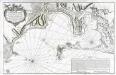
Carte hydrographique de la baye de Cadix
1 Karte : Kupferdruck ; 56 x 88 cm Bellin s.n.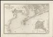
Mapa de los alrededores de Cádiz
1 : 36000 compuesto por A.H. Dufour la topografia grabada por Ch. Dyonnet ; la letra por Ch. Simon Cadiz [etc.] : Bulla
Kaart van de Baay van Cadix met de plans der fortificatien
1 : 15000 ten dienst der zeevaart opgesteld door William May, Luit. ter Zee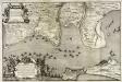
Plan de Cadix, de la baye, du Puntal de Port Marie, de Rotta, [et] de l'entrèe de la riviere de Guadalete
1 Plan auf 2 Blatt : Kupferdruck ; 48 x 72 cm chez Alberts et van der Kloot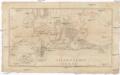
![Hispalensis Conventus Delineatio [Karte], in: Theatrum orbis terrarum, S. 101.](https://images-2.georeferencer.com/images/iiif/168348675631/full/,300/0/native.jpg)

