Maps of Denmark

Pascaert van Schager-Rack, De Belt, en de Orisondt; tot in de Oost Zee. [Karte], in: De Nieuwe Groote Vermeerderde Zee-Atlas ofte Water-Werelt, S. 23.
1 Karte aus Atlas Doncker, Hendrick
Daenemark.
1 : 1900000 Reichard, C. G.
Danemark, Schleswig, Holstein, Lauenburg.
1 : 1500000 Flemming, Carl
Dania regnum in quo sunt ducatus Holsatia et Slesvicum insulae Danicae et provinciae Iutia, Scania, Blekingia et Hallandia
1 : 1000000 1 Karte : Kupferdruck ; 48 x 57 cm Danckerts, Justus [Danckerts]
Regni Daniae in quo sunt Ducatus Holsatia et Slesvicum Insulae Danicae, Provinciae Iutia Scania Bleringia Nova Tabula
1 : 1100000 Mollova mapová sbírka Homann, Johann Baptist Homann, Johann Baptista
Le Royaume de Danemark Subdiuise en ses Principales Provinces Tiré de Plusier Momoires
1 : 1200000 Mollova mapová sbírka Valk, Gerhard Valck, Gerard
Daenemark
Schul-Atlas in 36 Karten Völter, Daniel Verlag der J.M. Dannheimer'schen Buchhandlung
Pas-Caarte van't Schager-Rack, De Sondt en de Belt. [Karte], in: De Nieuwe Groote Vermeerderde Zee-Atlas ofte Water-Werelt, S. 21.
1 Karte aus Atlas Doncker, Hendrick
Daenemark, Island.
1 : 875000 Weiland, C. F. (Carl Ferdinand), d. 1847
Danemark.
1 : 2250000 Malte-Brun, Conrad, 1775-1826
Daenemark
Dánsko Berra, Marco bei Marco Berra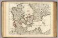
Danemarc.
1 : 965000 L'Isle, Guillaume de, 1675-1726
Danemarc.
1 : 970000 L'Isle, Guillaume de, 1675-1726
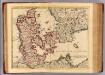
Daniae regnum cum ducatu Holsatiae et Slesvici nec non insulae Danicae et Iutia cum parte Scaniae
1 : 941000 Dánsko Lotter, Tobias Conrad studio Tobiae Conradi Lotteri
Karte von dem Koenigreiche Daenemark
1 : 1000000 Dánsko Reilly, Franz Johann Josef von Franz Ioh. Ios. von Reilly
Dania Regnum [Karte], in: Le théâtre du monde, ou, Nouvel atlas contenant les chartes et descriptions de tous les païs de la terre, Bd. 1, S. 49.
1 Karte aus Atlas Blaeu, Willem Janszoon und Blaeu, Joan Blaeu, Willem Janszoon
Daenemark, Schleswig, Holstein, Lauenburg, Island, Faer-Oer.
1 : 5400000 Brudin, J. L.; Stieler, Adolf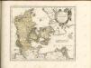

Regni Daniae Accuratissima delineatio. [Karte], in: Novus atlas absolutissimus, Bd. 1, S. 116.
1 Karte aus Atlas Janssonius Offizin
[Neueste Karte von Dänemark mit Holstein und Lauenburg, Mecklenburg Schwerin Strelitz, Oldenburg, die freien Städte Hamburg, Lübeck und Bremen]
Grosser Hand-Atlas über alle Theile der Erde in 170 Karten Meyer, J. Verlag des Bibliographischen Instituts

Daenemark, Island, die Far-Oer und die Herzogthümer Schleswig, Holstein & Lauenburg
1 : 860000 Dánsko Gräf, Carl Haubold, Georg Geographisches Institut
Daenemark, Island, die Far-Oer und die Herzogthümer Schleswig, Holstein & Lauenburg
1 : 800000 Dánsko Gräf, C. Haubold, G. Geographisches Institut
Charte des Königreichs Daenemark, nach Murdochischer Projection und nach den trigonometrischen Charten der König
1 : 919000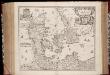
Regni Daniæ : novissima et accuratissima tabula / per Nicolaum Visscher
1 : 1150000 Annotatie: Origineel is Blad 144 in atlas factice; Annotatie geografische gegevens: Met schaalstok: Milliaria Germanica communia Nicolaes Jansz. Visscher jr. 1649-1702 [Amsterdam] : [Nicolaes Visscher]
Regni Daniae, Novißima et Accuratißima Tabula [Karte], in: Novus atlas absolutissimus, Bd. 1, S. 119.
1 Karte aus Atlas Janssonius Offizin
Dania Regnum [Karte], in: Novus Atlas, das ist, Weltbeschreibung, Bd. 1, S. 33.
1 Karte aus Atlas Blaeu, Joan Blaeu, Willem Janszoon

![Pascaert van Schager-Rack, De Belt, en de Orisondt; tot in de Oost Zee. [Karte], in: De Nieuwe Groote Vermeerderde Zee-Atlas ofte Water-Werelt, S. 23.](https://images-2.georeferencer.com/images/iiif/066990421774/full/,300/0/native.jpg)

