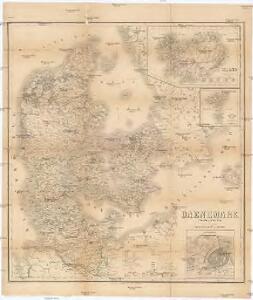
Maps of Denmark

Daenemark, Island, die Far-Oer und die Herzogthümer Schleswig, Holstein & Lauenburg
1 : 860000 Dánsko Gräf, Carl Haubold, Georg Geographisches Institut
Daenemark, Island, die Far-Oer und die Herzogthümer Schleswig, Holstein & Lauenburg
1 : 800000 Dánsko Gräf, C. Haubold, G. Geographisches Institut
Daenemark, Schleswig, Holstein, Lauenburg, Island, Faer-Oer.
1 : 5400000 Brudin, J. L.; Stieler, Adolf
Daenemark.
1 : 1900000 Reichard, C. G.
Danemark, Schleswig, Holstein, Lauenburg.
1 : 1500000 Flemming, Carl

Daniae regnum cum ducatu Holsatiae et Slesvici nec non insulae Danicae et Iutia cum parte Scaniae
1 : 941000 Dánsko Lotter, Tobias Conrad studio Tobiae Conradi Lotteri
Daenemark
Schul-Atlas in 36 Karten Völter, Daniel Verlag der J.M. Dannheimer'schen Buchhandlung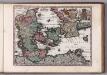
Daniae Reg. cum Ducatu Holsatiae et Slesvici
1 : 500000 Weyerman, Jacob Campo
Daenemark, Island.
1 : 875000 Weiland, C. F. (Carl Ferdinand), d. 1847
Charte des Königreichs Daenemark, nach Murdochischer Projection und nach den trigonometrischen Charten der König
1 : 919000
Danemark.
1 : 2250000 Malte-Brun, Conrad, 1775-1826
Denmark, Holstein, Mecklenburg, Island.
1 : 2000000 Meyer, Joseph, 1796-1856
[64][64] Dania Regnum ..., uit: Atlas sive Descriptio terrarum orbis
Annotatie: Gedigitaliseerde versie. Amsterdam. Heiloo : Picturae (vervaardiger), 2015. tiff-bestand. Gedigitaliseerd: 07-01-2015; Origineel: Universiteitsbibliotheek Vrije Universiteit (XL.05127.-) ; Netherlands; Titelpagina ontbreekt Wit, Frederik de Amsterdam : Frederick de Wit
Regni Daniae Novißima et Accuratißima Tabula
1 : 1100000 Mollova mapová sbírka Visscher, Nicolaes Visscher, Nicolaus
[DANIA REGNUM in quo sunt ducatus HOLSATIA et SLESVICUM INSULAE DANICAE et PROVINCIAE IUTIA, SCANIA, BLEKINGIA ET HALLANDIA]
1 : 1050000 Dánsko Wit, Frederick de F. de Wit
[Dänemark und die Dänischen Kolonien]
Handatlas über alle Theile der Erde und über das Weltgebäude Stieler, Adolf Justus Perthes
Dänemark, Schleswig, Holstein u. Lauenburg, nebst den Dänischen Colonien
Hand-Atlas über alle Theile der Erde und über das Weltgebäude Stieler, Adolf Justus Perthes
Denmark.
1 : 2400000 Bowen, Emanuel
[Königreich Daenemark]
Neuester Schul-Atlas Walch, Johann im Verlag bei Joh. Walch
Das Königreich Daenemark
1 : 1090000 Dánsko Weiland, Karl Ferdinand Geographisches Institut
[Neueste Karte von Dänemark mit Holstein und Lauenburg, Mecklenburg Schwerin Strelitz, Oldenburg, die freien Städte Hamburg, Lübeck und Bremen]
Grosser Hand-Atlas über alle Theile der Erde in 170 Karten Meyer, J. Verlag des Bibliographischen Instituts
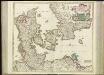
DANIA | REGNVM.
[Amsterdam : Joan Blaeu]
Daenemark
Allgemeiner Atlas [Walch, Johannes] im Verlag bei Johannes Walch
Regni Daniae in quo sunt Ducatus Holsatia et Slesvicum Insulae Danicae, Provinciae Iutia Scania Bleringia Nova Tabula
1 : 1100000 Mollova mapová sbírka Homann, Johann Baptist Homann, Johann Baptista
Le Royaume de Danemark Subdiuise en ses Principales Provinces Tiré de Plusier Momoires
1 : 1200000 Mollova mapová sbírka Valk, Gerhard Valck, Gerard

Daenemark
Dánsko Berra, Marco bei Marco Berra
Regni Daniae in quo sunt ducatus Holsatia et Slesvicum insulae Danicae provinciae Iutia Scania Blekingia nova tabula
1 : 1100000 Dánsko Homann, Johann Baptist
Regni Daniae, in quo sunt ducatus Holsatia et Slesvicum, insulae Danicae, provinciae Iutia Scania Blekingia etc. nova tabula
1 : 1100000 Dánsko Homann, Johann Baptist â Io. Baptista Homanno
Regni Daniae, in quo sunt ducatus Holsatia et Slesvicum, insulae Danicae, provinciae Iutia Scania Blekingia etc. nova tabula
1 : 1100000 Dánsko Homann, Johann Baptist â Io. Baptista Homanno