Maps of Denmark

Danemark.
1 : 2250000 Malte-Brun, Conrad, 1775-1826
[Neueste Karte von Dänemark mit Holstein und Lauenburg, Mecklenburg Schwerin Strelitz, Oldenburg, die freien Städte Hamburg, Lübeck und Bremen]
Grosser Hand-Atlas über alle Theile der Erde in 170 Karten Meyer, J. Verlag des Bibliographischen Instituts
Daenemark
Schul-Atlas in 36 Karten Völter, Daniel Verlag der J.M. Dannheimer'schen Buchhandlung
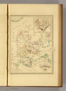
Denmark.
1 : 2400000 Bowen, Emanuel
Daenemark
Dánsko Berra, Marco bei Marco Berra
Atlas für Handel und Industrie: Für Kaufleute, Fabrikante u. Gewerbetreibende, Handlungs- u. Gewerbe-Schulen

Pas-Caarte van't Schager-Rack, De Sondt en de Belt. [Karte], in: De Nieuwe Groote Vermeerderde Zee-Atlas ofte Water-Werelt, S. 21.
1 Karte aus Atlas Doncker, Hendrick
Daenemark.
1 : 1900000 Reichard, C. G.
Danemark, Schleswig, Holstein, Lauenburg.
1 : 1500000 Flemming, Carl
[Königreich Daenemark]
Neuester Schul-Atlas Walch, Johann im Verlag bei Joh. Walch
Denmark, Holstein, Mecklenburg, Island.
1 : 2000000 Meyer, Joseph, 1796-1856

Daniae Regni Typus. [Karte], in: Theatrum orbis terrarum, S. 204.
1 Karte aus Atlas Ortelius, Abraham Vrients, Jan Baptista
Dania Regnum [Karte], in: Le théâtre du monde, ou, Nouvel atlas contenant les chartes et descriptions de tous les païs de la terre, Bd. 1, S. 49.
1 Karte aus Atlas Blaeu, Willem Janszoon und Blaeu, Joan Blaeu, Willem Janszoon
Daenemark, Island.
1 : 875000 Weiland, C. F. (Carl Ferdinand), d. 1847
Regni Daniae in quo sunt Ducatus Holsatia et Slesvicum Insulae Danicae, Provinciae Iutia Scania Bleringia Nova Tabula
1 : 1100000 Mollova mapová sbírka Homann, Johann Baptist Homann, Johann Baptista
Le Royaume de Danemark Subdiuise en ses Principales Provinces Tiré de Plusier Momoires
1 : 1200000 Mollova mapová sbírka Valk, Gerhard Valck, Gerard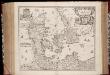
Regni Daniæ : novissima et accuratissima tabula / per Nicolaum Visscher
1 : 1150000 Annotatie: Origineel is Blad 144 in atlas factice; Annotatie geografische gegevens: Met schaalstok: Milliaria Germanica communia Nicolaes Jansz. Visscher jr. 1649-1702 [Amsterdam] : [Nicolaes Visscher]
Dania Regnum [Karte], in: Novus Atlas, das ist, Weltbeschreibung, Bd. 1, S. 33.
1 Karte aus Atlas Blaeu, Joan Blaeu, Willem Janszoon
Daenemark, Island, die Far-Oer und die Herzogthümer Schleswig, Holstein & Lauenburg
1 : 860000 Dánsko Gräf, Carl Haubold, Georg Geographisches Institut
Daenemark, Island, die Far-Oer und die Herzogthümer Schleswig, Holstein & Lauenburg
1 : 800000 Dánsko Gräf, C. Haubold, G. Geographisches Institut
Regni Daniae, Novißima et Accuratißima Tabula [Karte], in: Novus atlas absolutissimus, Bd. 1, S. 119.
1 Karte aus Atlas Janssonius Offizin
[Daenemark mit Schleswig, Holstein und Lauenburg auch Südl. Theil v. Schweden]
Hand-Atlas über alle Theile der Erde nach dem neuesten Zustande und über das Weltgebäude Stieler, Adolf bei Justus Perthes
[Dänemark und die Dänischen Kolonien]
Handatlas über alle Theile der Erde und über das Weltgebäude Stieler, Adolf Justus Perthes
Regni Daniae Accuratissima delineatio. [Karte], in: Novus atlas absolutissimus, Bd. 1, S. 116.
1 Karte aus Atlas Janssonius Offizin
Dänemark, Schleswig, Holstein u. Lauenburg, nebst den Dänischen Colonien
Hand-Atlas über alle Theile der Erde und über das Weltgebäude Stieler, Adolf Justus Perthes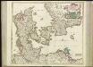
[64][64] Dania Regnum ..., uit: Atlas sive Descriptio terrarum orbis
Annotatie: Gedigitaliseerde versie. Amsterdam. Heiloo : Picturae (vervaardiger), 2015. tiff-bestand. Gedigitaliseerd: 07-01-2015; Origineel: Universiteitsbibliotheek Vrije Universiteit (XL.05127.-) ; Netherlands; Titelpagina ontbreekt Wit, Frederik de Amsterdam : Frederick de Wit
DANIA | REGNVM.
[Amsterdam : Joan Blaeu]
Daenemark
E. von Sydow's Schul-Atlas in sechs und dreissig Karten Sydow, Emil von bei Justus Perthes