Maps of Greenland

Nova Et Accurata Poli Arctici et terrarum Circum Iacentium Descriptio. [Karte], in: Novus atlas absolutissimus, Bd. 9, S. 55.
1 Karte aus Atlas Janssonius Offizin
[140][143] Poli Arctici ..., uit: Atlas sive Descriptio terrarum orbis
Annotatie: Gedigitaliseerde versie. Amsterdam. Heiloo : Picturae (vervaardiger), 2015. tiff-bestand. Gedigitaliseerd: 07-01-2015; Origineel: Universiteitsbibliotheek Vrije Universiteit (XL.05127.-) ; Netherlands; Titelpagina ontbreekt Wit, Frederik de Amsterdam : Frederick de Wit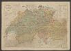
Septentrionalium Terrarum descriptio. [Karte] Frislant insula [Nebenkarte] Farre insulae [Nebenlarte] Scetland insulae [Nebenlarte], in: Gerardi Mercatoris Atlas, sive, Cosmographicae meditationes de fabrica mundi et fabricati figura, S. 76.
1 Karte aus Atlas Mercator, Gerhard Montanus, Petrus
Amerique Boreale.
1 : 12000000 Montemont, A.
Regiones Sub Polo Arctico. [Karte], in: Theatrum orbis terrarum, sive, Atlas novus, Bd. 1, S. 31.
1 Karte aus Atlas Blaeu, Joan Blaeu, Willem Janszoon
Extreme Limits of Ice, 1998 - 1938, April - August
U.S. Navy
Scandinavia, comprehending Norway, Sueden, and part of Denmark.
from New & accurate description of the earth in all its empires, kingdoms and states
L'empire de Russie, en Europe et en Asie
1 : 12640000 Rusko Bonne, Rigobert André
Nova Et Accurata Poli Arctici et terrarum Circum Iacentium Descriptio. [Karte], in: Het vijfde Deel Des Grooten Atlas : Vervatende De Water-Weereld, S. 53.
1 Karte aus Atlas Jansson, Jan Jansson, Jan
E. Siberia.
1 : 11000000 Society for the Diffusion of Useful Knowledge (Great Britain)
REGIONES | SVB POLO ARCTICO
Auctore Guiljelmo Blaeu [Amsterdam : Joan Blaeu]
Amerique Russe, regions polaires boreales.
1 : 13000000 Garnier, F. A., 1803-1863
Russie orientale.
1 : 13000000 Bonne, Rigobert, 1727-1794
Regiones svb polo arctico / auctore Guiljelmo Blaeu
1 : 13500000 Annotatie: Met wapen; Met opdracht van Joh. Blaeu aan Guilielmus Backer de Corneliis; Origineel is Blad 147 in atlas factice; Annotatie geografische gegevens: Met 3 schaalstokken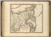
Russian Empire east.
1 : 9400000 Cary, John, ca. 1754-1835
Partie orientale de l'empire de Russie / projettée et assujetie aux observations astronomiques post
1 : 13000000 1 Karte : Kupferdruck ; 42 x 30 cm Bonne, Rigobert chez Lattré ruë St. Jacques à la ville de Bordeaux
Spesielle kart 152: Norge med biland og tilgrensende land- og havmområder
1 : 6000000 Gauss KrÃ1⁄4ger Norsk Polarinstitutt | Norges geografiske oppmÃ¥ling | Norges Sjà ̧kartverk
NW America.
1 : 11900000 Mitchell, Samuel Augustus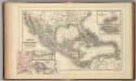
Mexico, Central America, West Indies.
1 : 12000000 Mitchell, Samuel Augustus
NW America.
1 : 11900000 Mitchell, Samuel Augustus Jr.
NW America.
1 : 11900000 Mitchell, Samuel Augustus
NW America.
1 : 11900000 Mitchell, Samuel Augustus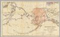
Northwestern America Showing The Territory Ceded By Russia To The United States.
1 : 5000000 Sumner, Charles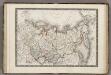
Siberie ou Russie d'Asie.
1 : 18000000 Monin, C.V.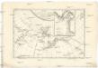
Carte de la côte N.O. del'Amerique et de la côte N.E. de l Asie reconnues en 1778 et 1779
1 : 13700000 Asie východní Bonne, Rigobert André
Facsimile: Russian Chart of the Frozen Ocean and the Eastern Ocean.
1 : 9800000 Alaskan Boundary Tribunal
A new map of ancient Scandinavia, together with as much more of ye northern part of ancient Europe as answers to present Denmark & Moscovia.
from A new sett of maps both of antient and present geography : wherein not only the latitude and longitude of many places are corrected according to the latest observations, but also the most remarkable differences of antient and present geography may be quickly discern'd by a bare inspection or comparing of correspondent maps, which seems to be the most natural and easy method to lead young students (for whose use the work is principally intended) unto a competent knowledge of the geographical science : together with a geographical treatise particularly adapted to the use and design of these maps / by Edward Wells, M.A. and student of Christ-Church, Oxon.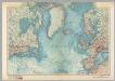
North Atlantic. Pergamon World Atlas.
1 : 15000000 Polish Army Topography Service
(Russia in Asia 2)
1 : 10454400 Letts, Son & Co.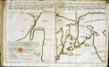
![Nova Et Accurata Poli Arctici et terrarum Circum Iacentium Descriptio. [Karte], in: Novus atlas absolutissimus, Bd. 9, S. 55.](https://images-2.georeferencer.com/images/iiif/064290337622/full/,300/0/native.jpg)

