Maps of Northern European Plain

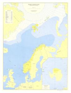
Spesielle kart 152: Norge med biland og tilgrensende land- og havmområder
1 : 6000000 Gauss KrÃ1⁄4ger Norsk Polarinstitutt | Norges geografiske oppmÃ¥ling | Norges Sjà ̧kartverk
REGIONES | SVB POLO ARCTICO
Auctore Guiljelmo Blaeu [Amsterdam : Joan Blaeu]
Moscovia.
from A new systeme of the mathematicks: containing I. Arithmetick, as well natural and decimal, as in species, or the principles of algebra. II. Practical geometry, together with the first six books of Euclid's Elements, as also the eleventh and twelfth, symbo
Scandinavia, comprehending Norway, Sueden, and part of Denmark.
from New & accurate description of the earth in all its empires, kingdoms and states
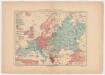
Ubersicht von Europa; mit ethnograph.
1 : 19008000 Berghaus, Heinrich
Nova Et Accurata Poli Arctici et terrarum Circum Iacentium Descriptio. [Karte], in: Het vijfde Deel Des Grooten Atlas : Vervatende De Water-Weereld, S. 53.
1 Karte aus Atlas Jansson, Jan Jansson, Jan
Regiones Sub Polo Arctico. [Karte], in: Theatrum orbis terrarum, sive, Atlas novus, Bd. 1, S. 31.
1 Karte aus Atlas Blaeu, Joan Blaeu, Willem Janszoon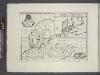
A new map of ancient Scandinavia, together with as much more of ye northern part of ancient Europe as answers to present Denmark & Moscovia.
from A new sett of maps both of antient and present geography : wherein not only the latitude and longitude of many places are corrected according to the latest observations, but also the most remarkable differences of antient and present geography may be quickly discern'd by a bare inspection or comparing of correspondent maps, which seems to be the most natural and easy method to lead young students (for whose use the work is principally intended) unto a competent knowledge of the geographical science : together with a geographical treatise particularly adapted to the use and design of these maps / by Edward Wells, M.A. and student of Christ-Church, Oxon.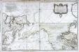
Carte réduite de l'ocean septentrional compris entre l'Asie et l'Amérique
1 Karte : Kupferdruck ; 54 x 84 cm Bellin s.n.
Europe.
1 : 20275200 Melish, John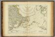
The Russian Discoveries
1 : 15400000 Jefferys, Thomas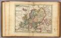
Europe.
1 : 29000000 Moll, Herman, d. 1732
Europa
1 : 30000 Evropa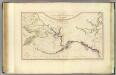
NW America, NE Asia.
1 : 8800000 Roberts, Henry, Lieut.
Nova Et Accurata Poli Arctici et terrarum Circum Iacentium Descriptio. [Karte], in: Novus atlas absolutissimus, Bd. 9, S. 55.
1 Karte aus Atlas Janssonius Offizin
N.W. coast America, N.E. coast Asia.
1 : 8700000 Cook, James, 1728-1779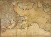
Nouvelle carte des decouvertes faites par des vaisseaux russiens aux côtes inconnues de l'Amerique septentrionale avec les pais adiacents
1 Karte auf 2 Blatt : Kupferdruck ; 44 x 62 cm Rey; Schenk chez Marc Michel Rey
Nouvelle carte des decouvertes faites par des vaisseaux russiens aux côtes inconnues de l'Amerique septentrionale avec les pais adiacents
1 Karte : Kupferdruck ; 47 x 61 cm a l'Academie imperiale des sciences
Map of the Dominion of Canada
1 : 6310000 Kanada National Resources Intelligence Service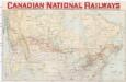
Canadian national railways
1 : 3065000 Kanada Poole Bros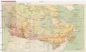
Resource map of the Dominion of Canada
1 : 12000000 Kanada Cory, William Wallace Department of the Interior
E. Siberia.
1 : 11000000 Society for the Diffusion of Useful Knowledge (Great Britain)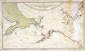
Karte von den n. w. amerikanischen und n. oe. asiatischen Küsten
1 Karte : Kupferdruck ; 38 x 66 cm Schrämbl; Roberts; Lackner zu finden in eigenem Verlage Schrämbl
Versuch Einer Ubersicht Der Geographischen Verbreitung Der Gewitter.
Berghaus, Heinrich
Verbreitung der Mammalia oder Saugethiere in Europa.
1 : 15000000 Berghaus, Heinrich
Amerique Russe, regions polaires boreales.
1 : 13000000 Garnier, F. A., 1803-1863
North western America showing the territory ceded by Russia to the United States.
1 : 12100000 United States Coast Survey
North western America showing the territory ceded by Russia to the United States.
1 : 12100000 United States Coast Survey