Maps of Mediterranean Sea
Italia XIIII. Nova Tabula [Karte], in: Claud. Ptolemaeus. Geographia lat. cum mappis [...], S. 395.
1 Karte aus Atlas Münster, Sebastian [und Ptolemaeus, Claudius]
Italia XIIII. Nova Tabula [Karte], in: Geographia universalis vetus et nova complectens Claudii Ptolemaei Alexandrini enarrationis libros VIII, S. 341.
1 Karte aus Atlas Münster, Sebastian [und Ptolemaeus, Claudius]
Tabula Moderna Et Nova Italie Ac Sicilie [Karte], in: Claudii Ptolemei viri Alexandrini mathematice discipline philosophi doctissimi geographie opus [...], S. 254.
1 Karte aus Atlas Waldseemüller, Martin [und Ptolemaeus, Claudius] Übelin, Georg
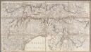
L'Italie distinguée suivant l'estendüe de tous les Estats, Royaumes, Republiques, Duchés, Pricipautés qui la partagent presentement [Karte], in: Atlas nouveau, contenant toutes les parties du monde [...], Bd. 2, S. 121.
1 Karte aus Atlas Sanson, Nicolas Jaillot, Alexis Hubert und Mortier, Pieter
Carta geografica statistica e postale dell'Italia
From Whole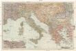
Italien und die Balkanstaaten
1 : 3000000 Itálie von Velhagen & Klasing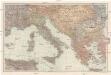
[Italien und die Balkanstaaten]
1 : 3000000 Itálie Velhagen & Klasing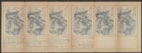
Italia XIX. Nova Tabula. [Karte], in: Claud. Ptolemaeus. Geographia lat. cum mappis [...], S. 419.
1 Karte aus Atlas Münster, Sebastian [und Ptolemaeus, Claudius]
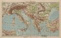
Italien und Balkanhalbinsel
1 : 6000000 Balkanhalbinsel, Italien
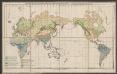
Homannův atlas světa
1 : 2100000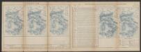
Tabula Europae V. [Karte], in: Claud. Ptolemaeus. Geographia lat. cum mappis [...], S. 266.
1 Karte aus Atlas Münster, Sebastian [und Ptolemaeus, Claudius]
Italien
1 : 5000000 1 Karte Top. Anstalt v. J. Wurster, Winterthur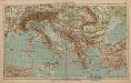
Italien und Balkanhalbinsel
1 : 9000000 Balkanhalbinsel, Italien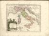
Tabula Europae VI. [Karte], in: Claud. Ptolemaeus. Geographia lat. cum mappis [...], S. 269.
1 Karte aus Atlas Münster, Sebastian [und Ptolemaeus, Claudius]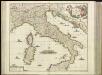
[27][27]Novissima et accuratissima totius Italiae, Corsicae et Sardiniae descriptio, uit: Atlas sive Descriptio terrarum orbis
Annotatie: Gedigitaliseerde versie. Amsterdam. Heiloo : Picturae (vervaardiger), 2015. tiff-bestand. Gedigitaliseerd: 07-01-2015; Origineel: Universiteitsbibliotheek Vrije Universiteit (XL.05127.-) ; Netherlands; Titelpagina ontbreekt Wit, Frederik de Amsterdam : Frederick de Wit
Karte der Eisenbahnen Mittel-Europa's
1 : 1850000 Evropa střední Müller, H. C. Flemming
Italien
Neuester Schul-Atlas Walch, Johann im Verlag bei Joh. Walch
Karte von Italien
1 : 3040000 Itálie Reilly, Franz Johann Josef von Anville, Jean-Baptiste Bourguinon d' Franz Joh. Jos. von Reilly
[LL.07786gk: 100/od/1943], uit: Kompas van Italië en Zuid-Oost Europa
1 : 3500000 Annotatie: Ook op de kaart: Tom Tas van Kompas; Vrijgegeven door W.B.N. [Wehrmachts Bereich in den Niederlanden] 30.10.'43; Grenzen van 1 sept. 1939; Op verso: incompleet gedeelte van wat waarschijnlijk poster is geweest, met tekst: Oranje Boot, half om half Den Haag : Kompas
Italien
Handatlas über alle Theile der Erde und über das Weltgebäude Stieler, Adolf Justus Perthes
Italien
Hand-Atlas über alle Theile der Erde und über das Weltgebäude Stieler, Adolf Justus Perthes
Map of Italy.
1 : 6050000 Bowen, Emanuel
[LL.03949gk: 100/od/1943], uit: Kompas van Italië en Zuid-Oost Europa
1 : 3500000 Annotatie: Ook op de kaart: Tom Tas van Kompas; Vrijgegeven door W.B.N. [Wehrmachts Bereich in den Niederlanden] 30.10.'43; Grenzen van 1 sept. 1939; Op verso: incompleet gedeelte van wat waarschijnlijk poster is geweest, met tekst: Oranje Boot, half om half Den Haag : Kompas
Tabula Europae VI. [Karte], in: Geographia universalis vetus et nova complectens Claudii Ptolemaei Alexandrini enarrationis libros VIII, S. 239.
1 Karte aus Atlas Münster, Sebastian [und Ptolemaeus, Claudius]
Prussian States.
1 : 5200000 Arrowsmith, Aaron; Lewis, Samuel
Soubor map
![Italia XIIII. Nova Tabula [Karte], in: Claud. Ptolemaeus. Geographia lat. cum mappis [...], S. 395.](https://images-2.georeferencer.com/images/iiif/484104089373/full/,300/0/native.jpg)

