Maps of Mediterranean Sea

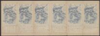
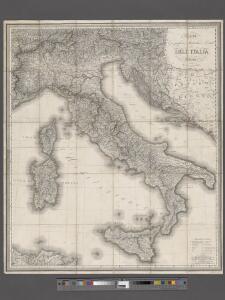
Carta geografica statistica e postale dell'Italia
From Whole
Italien
1 : 5000000 1 Karte Top. Anstalt v. J. Wurster, Winterthur
[LL.03949gk: 100/od/1943], uit: Kompas van Italië en Zuid-Oost Europa
1 : 3500000 Annotatie: Ook op de kaart: Tom Tas van Kompas; Vrijgegeven door W.B.N. [Wehrmachts Bereich in den Niederlanden] 30.10.'43; Grenzen van 1 sept. 1939; Op verso: incompleet gedeelte van wat waarschijnlijk poster is geweest, met tekst: Oranje Boot, half om half Den Haag : Kompas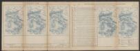
Tabula Europae V. [Karte], in: Claud. Ptolemaeus. Geographia lat. cum mappis [...], S. 266.
1 Karte aus Atlas Münster, Sebastian [und Ptolemaeus, Claudius]
Italia XIIII. Nova Tabula [Karte], in: Geographia universalis vetus et nova complectens Claudii Ptolemaei Alexandrini enarrationis libros VIII, S. 341.
1 Karte aus Atlas Münster, Sebastian [und Ptolemaeus, Claudius]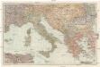
Italien und die Balkanstaaten
1 : 3000000 Itálie von Velhagen & Klasing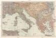
[Italien und die Balkanstaaten]
1 : 3000000 Itálie Velhagen & Klasing
Tabula Moderna Et Nova Italie Ac Sicilie [Karte], in: Claudii Ptolemei viri Alexandrini mathematice discipline philosophi doctissimi geographie opus [...], S. 254.
1 Karte aus Atlas Waldseemüller, Martin [und Ptolemaeus, Claudius] Übelin, Georg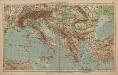
Italien und Balkanhalbinsel
1 : 9000000 Balkanhalbinsel, Italien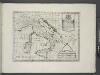
Italy, Sicily, &c.
from A new sett of maps both of antient and present geography : wherein not only the latitude and longitude of many places are corrected according to the latest observations, but also the most remarkable differences of antient and present geography may be quickly discern'd by a bare inspection or comparing of correspondent maps, which seems to be the most natural and easy method to lead young students (for whose use the work is principally intended) unto a competent knowledge of the geographical science : together with a geographical treatise particularly adapted to the use and design of these maps / by Edward Wells, M.A. and student of Christ-Church, Oxon.
Veränderungen der Karte von Europa seit 1815
1 : 3800000 Evropa Wenzel, Joh. K. J.G. Calve'sche k. k. Hof- und Universitäts-Buchhandlung
[Historisch-geographischer Atlas zu den allgemeinen Geschichtswerken von C. v. Rotteck, Pölitz u. Becker] : Italien eine Uebersicht seiner Völker und Staaten in der ältesten Zeit
von Julius Loewenberg Lithographie von B. Herder in Freiburg im Breisgau [Freiburg im Breisgau] : [Herder]
Italia XIIII. Nova Tabula [Karte], in: Claud. Ptolemaeus. Geographia lat. cum mappis [...], S. 395.
1 Karte aus Atlas Münster, Sebastian [und Ptolemaeus, Claudius]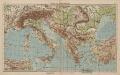
Italien und Balkanhalbinsel
1 : 6000000 Balkanhalbinsel, Italien
[LL.07786gk: 100/od/1943], uit: Kompas van Italië en Zuid-Oost Europa
1 : 3500000 Annotatie: Ook op de kaart: Tom Tas van Kompas; Vrijgegeven door W.B.N. [Wehrmachts Bereich in den Niederlanden] 30.10.'43; Grenzen van 1 sept. 1939; Op verso: incompleet gedeelte van wat waarschijnlijk poster is geweest, met tekst: Oranje Boot, half om half Den Haag : Kompas

Quinta Europae Tabula [Retia, Vindelicia, Noricum, Pannonia Superior, Panonnia Inferior [...]] [Karte], in: Claudii Ptolemei viri Alexandrini mathematice discipline philosophi doctissimi geographie opus [...], S. 163.
1 Karte aus Atlas Waldseemüller, Martin [und Ptolemaeus, Claudius] Übelin, Georg
Italy, Turkey, Greece, Europe.
Goodrich, S.G.
Bullettino decadico dell'osservatorio ed archivio centrale geodinamico
1 : 1200000 1886/8, Blatt 2 Archivio Centrale Geodinamico

Prussian States.
1 : 5200000 Arrowsmith, Aaron; Lewis, Samuel
L'Italie distinguée suivant l'estendüe de tous les Estats, Royaumes, Republiques, Duchés, Pricipautés qui la partagent presentement [Karte], in: Atlas nouveau, contenant toutes les parties du monde [...], Bd. 2, S. 121.
1 Karte aus Atlas Sanson, Nicolas Jaillot, Alexis Hubert und Mortier, Pieter
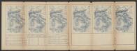
Bullettino decadico dell'osservatorio ed archivio centrale geodinamico
1 : 1200000 1886/31, Blatt 2 Archivio Centrale Geodinamico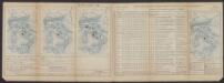
Bullettino decadico dell'osservatorio ed archivio centrale geodinamico
1 : 1200000 1885/4, Blatt 1 Archivio Centrale Geodinamico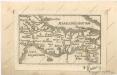
Soubor map
Bullettino decadico dell'osservatorio ed archivio centrale geodinamico
1 : 1200000 1886/22, Blatt 2 Archivio Centrale Geodinamico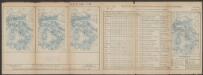
Bullettino decadico dell'osservatorio ed archivio centrale geodinamico
1 : 1200000 1885/33, Blatt 1 Archivio Centrale Geodinamico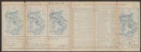
Bullettino decadico dell'osservatorio ed archivio centrale geodinamico
1 : 1200000 1885/32, Blatt 1 Archivio Centrale Geodinamico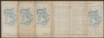
Bullettino decadico dell'osservatorio ed archivio centrale geodinamico
1 : 1200000 1885/31, Blatt 1 Archivio Centrale Geodinamico