Maps of Switzerland
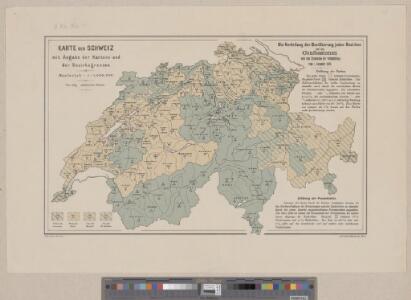
Karte der Schweiz mit Angabe der Kantons- und der Bezirksgrenzen
1 : 1050000 1 Karte vom eidg. statistischen Bureau ; Lith. Gebr. Kümmerly Eidg. statist. Bureau, [Bern]
[Schweiz]
1 : 520000 1 Karte [Keller?], [Zürich?]
<<La>> Suisse divisée en ses treize cantons et ses alliés
1 : 850000 1 Karte projettée et assujettie aux observations astronomiques par [Rigobert] Bonne chez Lattré, rue S. Jacques, à la ville de Bordeaux, Paris
République helvétique divisée en ses 22 cantons
1 : 1000000 1 Karte par F.x Delamarche [chez Félix Delamarche, ingénieur-mécanicien pour les globes et sphères, rue du jardinet, no. 13], [Paris]
Historisch-Geographischer Atlas der Schweiz in 15 Blättern
1 : 770000 Helvetien 450 - 879 Voegelin, Johann Conrad ; Meyer von Knonau, Gerold ; Wyss, Georg von ; Meyer von Knonau, Gerold Schulthess
Johnson's Switzerland
1 : 970000 1 Karte by Johnson and Ward Johnson and Ward, New York
Johnson's Switzerland
1 : 970000 1 Karte by Johnson and Ward Johnson and Ward, New York
<<La>> Suisse divisée en ses treze cantons, ses alliéz & ses sujets
1 : 480000 1 Karte par le Sr. Sanson, géographe du roy chez H. Jaillot, Paris
<<Die>> Helvetische Republik in Cantone und Districte eingetheilt
1 : 630000 1 Karte gedruckt bey Wilhelm Haas dem Sohne, Basel
Carte physique et politique de la Suisse
1 : 900000 1 Karte par E. Mentelle et P.G. Chanlaire an VI ; gravé par [Alexandre] Blondeau P.G. Chanlaire et E. Mentelle, Paris
Charte von der Schweiz nach ihrer jezigen Eintheilung
1 : 880000 1 Karte [Joseph Dirwaldt] Mollo, Wien
<<Les>> XIII. cantons des Suisses, leurs alliéz et leurs sujets
1 : 1000000 1 Karte par N. de Fer ; C. Inselin sculpt. chez l'auteur dans l'Isle du Palais à la Sphère Royale, Paris
<<Die>> Helvetische Republik in Cantone und Districte eingetheilt
1 : 630000 1 Karte gedruckt bey Wilhelm Haas dem Sohne, Basel
Helvetia tredecim statibus liberis quos cantones vocant, composita, una cum foederatis & subjectis provinciis
1 : 650000 1 Karte ex probatissimis subsidiis geographice delineata per Tobiam Mayerum luci publicae tradita ab Homannianis Heredibus, Norimbergae
Nova totius Helvetiae cum suis subditis ac sociis tab. geogr
1 : 1400000 1 Karte studio manu ac sumtibus Matth. Seutter ; Tob. Conr. Lotter sc. anjezo im Verlag bey Tob Conr. Lotter, Augsburg
<<La>> Suisse
1 : 1500000 1 Karte [Verlag nicht ermittelbar], [Erscheinungsort nicht ermittelbar]
Historisch-Geographischer Atlas der Schweiz in 15 Blättern
1 : 770000 Helvetien 888 - 1037 Voegelin, Johann Conrad ; Meyer von Knonau, Gerold ; Wyss, Georg von ; Meyer von Knonau, Gerold Schulthess
<<Die>> alten Bisthümer von Helvetien und Raetien
1 : 2000000 1 Karte [bearb. nach Urkunden und den vorzüglichsten Werken Schweizerischer Geschichte von E. Scheuermann] [Scheuermann], [Aarau]
Carte physique et politique de la Suisse
1 : 1050000 1 Karte dréssée par L. Dussieux ; gravée par Martier [Lecoffre], [Paris]
<<Die>> Schweiz, oder, Helvetische Eidgenossenschaft
1 : 580000 1 Karte entworfen und gezeichnet von C. F. Weiland Im Verlag des Geograph. Instituts, Weimar
Carte générale des trèze cantons de Suisse, Vallay, ligues Grise, Maison-Dieu & Valteline
1 : 725000 1 Karte A Paris au bout du pont neuf proche les Augustins
Carte générale de la Suisse
1 Karte dressée en 1787 d'apres les observations les plus récentes et les plus exactes, pour servir a la nouvelle édition très augmentée du dictionnaire de la Suisse chez BMC [i.e. Barde, Manget & Compagnie], Genève
Atlas novus Reipublicae Helveticae
1 Atlas ([40] Bl., 97 S.) bey Orell, Gessner und Compagnie, Zürich
<<La>> Suisse
1 Karte par P. Du Val ; Somer sculp. et l'Alleman chez l'autheur en l'Isle du Palais sur le Quay de l'Horloge, Paris
<<Die>> Schweiz
1 : 1025000 1 Karte entw. u. gez. von [Friedrich H.] Handke [i.e. Handtke] ; H. Müller lith. [Flemming], [Glogau]
<<Der>> Kriegsschauplatz in der Schweiz
1 : 1725000 1 Karte Lith. v. F. Malté [Allgemeine Zeitung], [Augsburg oder München]
Historisch-Geographischer Atlas der Schweiz in 15 Blättern
1 : 770000 Eidgenossenschaft 1412 - 1481 Voegelin, Johann Conrad ; Meyer von Knonau, Gerold ; Wyss, Georg von ; Meyer von Knonau, Gerold Schulthess
<<La>> Suisse
1 Karte par P. Du Val ; Somer sculp. et l'Alleman chez l'autheur, Paris
Atlas novus Reipublicae Helveticae
1 Atlas ([40] Bl., 97 S.) bey Orell, Gessner und Compagnie, Zürich