Maps of Switzerland

Carte physique et politique de la Suisse
1 : 900000 1 Karte par E. Mentelle et P.G. Chanlaire an VI ; gravé par [Alexandre] Blondeau P.G. Chanlaire et E. Mentelle, Paris
<<Die>> Helvetische Republik in Cantone und Districte eingetheilt
1 : 630000 1 Karte gedruckt bey Wilhelm Haas dem Sohne, Basel
Johnson's Switzerland
1 : 970000 1 Karte by Johnson and Ward Johnson and Ward, New York
Helvetia tredecim statibus liberis quos cantones vocant, composita, una cum foederatis & subjectis provinciis
1 : 650000 1 Karte ex probatissimis subsidiis geographice delineata per Tobiam Mayerum luci publicae tradita ab Homannianis Heredibus, Norimbergae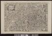
<<La>> Suisse divisée en ses treze cantons, ses alliéz & ses sujets
1 : 480000 1 Karte par le Sr. Sanson, géographe du roy chez H. Jaillot, Paris
<<La>> Suisse
1 Karte par P. Du Val ; Somer sculp. et l'Alleman chez l'autheur, Paris
Johnson's Switzerland
1 : 970000 1 Karte by Johnson and Ward Johnson and Ward, New York
Helvetiae conterminarumque terrarum antiqua descriptio
1 : 2000000 1 Karte [Stich von Girolamo Porro] ; [hrsg. von Giovanni Antonio Magini] [Verlag nicht ermittelbar], [Erscheinungsort nicht ermittelbar]
<<Die>> Helvetische Republik in Cantone und Districte eingetheilt
1 : 630000 1 Karte gedruckt bey Wilhelm Haas dem Sohne, Basel
Atlas novus Reipublicae Helveticae
1 Atlas ([40] Bl., 97 S.) bey Orell, Gessner und Compagnie, Zürich
Historisch-Geographischer Atlas der Schweiz in 15 Blättern
1 : 770000 Helvetien 888 - 1037 Voegelin, Johann Conrad ; Meyer von Knonau, Gerold ; Wyss, Georg von ; Meyer von Knonau, Gerold Schulthess
<<Les>> Suisses, leurs alliéz, avec les sujets des Suisses et des alliez
1 Karte selon les mémoires de Sjmler, de Gyger, et de plusieurs autres autheurs, par le Sr. Tillemon chez J.B. Nolin, Rue St-Jacques à l'enseigne de la Place des Victoires, Paris
Carte générale de la Suisse
1 Karte dressée en 1787 d'apres les observations les plus récentes et les plus exactes, pour servir a la nouvelle édition très augmentée du dictionnaire de la Suisse chez BMC [i.e. Barde, Manget & Compagnie], Genève
<<Die>> katholische und reformierte Schweiz seit der Reformation
1 : 2000000 1 Karte [bearb. nach Urkunden und den vorzüglichsten Werken Schweizerischer Geschichte von E. Scheuermann] [Scheuermann], [Aarau]
Historisch-Geographischer Atlas der Schweiz in 15 Blättern
1 : 770000 Eidgenossenschaft 1412 - 1481 Voegelin, Johann Conrad ; Meyer von Knonau, Gerold ; Wyss, Georg von ; Meyer von Knonau, Gerold Schulthess
<<La>> Suisse divisée en ses treze cantons, ses alliéz & ses sujets
1 Karte par le Sr. Sanson, géographe du roy chez P. Mortier et Compagnie, Amsterdam
<<Les>> XIII. cantons des Suisses, leurs alliéz et leurs sujets
1 : 1000000 1 Karte par N. de Fer ; C. Inselin sculpt. chez l'auteur dans l'Isle du Palais à la Sphère Royale, Paris
<<La>> Suisse divisée en ses treize cantons et ses alliés
1 : 850000 1 Karte projettée et assujettie aux observations astronomiques par [Rigobert] Bonne chez Lattré, rue S. Jacques, à la ville de Bordeaux, Paris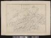
[Schweiz]
1 : 520000 1 Karte [Keller?], [Zürich?]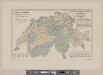
Karte der Schweiz mit Angabe der Kantons- und der Bezirksgrenzen
1 : 1050000 1 Karte vom eidg. statistischen Bureau ; Lith. Gebr. Kümmerly Eidg. statist. Bureau, [Bern]
Carte générale des trèze cantons de Suisse, Vallay, ligues Grise, Maison-Dieu & Valteline
1 : 725000 1 Karte A Paris au bout du pont neuf proche les Augustins
<<Die>> Schweiz
1 : 1025000 1 Karte entw. u. gez. von [Friedrich H.] Handke [i.e. Handtke] ; H. Müller lith. [Flemming], [Glogau]
<<Die>> alten Bisthümer von Helvetien und Raetien
1 : 2000000 1 Karte [bearb. nach Urkunden und den vorzüglichsten Werken Schweizerischer Geschichte von E. Scheuermann] [Scheuermann], [Aarau]
Historisch-Geographischer Atlas der Schweiz in 15 Blättern
1 : 770000 Eidgenossenschaft 1481 - 1652 Voegelin, Johann Conrad ; Meyer von Knonau, Gerold ; Wyss, Georg von ; Meyer von Knonau, Gerold Schulthess
Carte physique et politique de la Suisse
1 : 1050000 1 Karte dréssée par L. Dussieux ; gravée par Martier [Lecoffre], [Paris]
Atlas der alten Eidgenossenschaft in 20 Karten: Schweiz
Originaltitel: Helvetia Tredecim Statibus Liberis quos Cantones vocant, composita. Una cum foederatis et subjectis Provinciis, ex probatissimis subsidiis. Mit Erklärung der Zeichen und Zeichnungen der Kantonswappen. Zeichnung: Meyer, Tobias, Mathematik-Professor, in Göttingen Herausgeber: Homännische Erben
Eswīğra
1 : 1000000 1 Karte [graviert, übersetzt und gedruckt von] ʿAlī Šaraf Pāšā Dar-e Saʿādat, Matbaʿ-e ʿĀmire, [İstanbul]
<<Die>> schweiz. Abstimmung vom 12. Mai 1872
1 : 1250000 1 Karte [Verlag nicht ermittelbar], [Erscheinungsort nicht ermittelbar]
<<La>> Suisse
1 : 1500000 1 Karte [Verlag nicht ermittelbar], [Erscheinungsort nicht ermittelbar]


