Maps of North
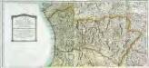
Mapa general del reyno de Portugal, 1
2 Blätter : 35 x 78 cm Tomás López
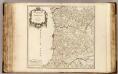
Mapa de la provincia de Entre Duero y Miño
1 Karte : Kupferdruck ; 32 x 27 cm López s.n.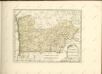

Mappa ou carta geographica dos reinos de Portugal e Algarve, 1
1 Blatt : 55 x 44 cm Dury


Mapa de la provincia de Tras-Los-Montes
1 Karte : Kupferdruck ; 32 x 27 cm López s.n.
Portugal 1:100,000. 7
1 : 100000 Portugal. Direcção dos Trabalhos Geodesicos do Reino [Lisbonne] : Direcção Geral dos Trabalhos Geodesicos do Reino
Plan von Porto
Porto (Portugalsko) bei Winckelmann & Söhne
Entrance of the river Douro
Belcher, Edward
"Oporto. Porto. View of Oporto from Torre da Marca"
1 Mapa i 1 vista. Datat entre 1830 i 1839 aproximadament. W. B. Clarke
Siege d'Almeida
1 Karte : Kupferdruck ; 23 x 23 cm Therbu; Cöntgen s.n.
Carta de Portugal, aprovada para uso das escolas / Direccâo Geral dos Trabalhos Geodesicos e Topographicos
1 : 500000 Direcçâo Geral dos Trabalhos Geodesicos e Topographicos
Partie septentrionale du royaume de Portugal
1 Karte : Kupferdruck ; 47 x 51 cm Robert de Vaugondy G. et D. Robert de Vaugondy
Regni Portugalliae provincias tres septentrionales Beiram, Transmontanam [et] Interamniam
1 Karte : Kupferdruck ; 53 x 44 cm Güssefeld; López Homann. haered
Parte septentrional do reyno de Portugal
1 Karte : Kupferdruck ; 40 x 52 cm Sanson em casa do autor
Partie septentrionale du royaume de Portugal
1 Karte : Kupferdruck ; 47 x 52 cm Bellin; Santini; Remondini chez M. Remondini
Il Portogallo cioè le provincie di Entre Douro, e Minho, Traz-Os-Montes, e Beira
1 Karte : Kupferdruck ; 30 x 40 cm Zatta Antonio Zatta
Portvgallia et Algarbia quae olim Lvsitania
1 : 1440000 Algarve (Portugalsko) Secco, Vernando Alvero Janssonius, Johannes apud Joannem Janßonnium
Portugal 4.
1 : 1774080 Letts, Son & Co.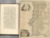
Portugal septentrionale.
1 : 680000 Robert de Vaugondy, Gilles, 1688-1766
Carta de Portugal
1 : 1500000 Portugalsko Instit. Geogr. e Cadastral
Carta hipsometrica de Portugal
1 : 1000000 Portugalsko Direçao Geral dos Trabalhadores Geodesicos e Topograficos
[Carte d'Espagne et de Portugal en neuf feuilles, 1]
1 Blatt : 31 x 41 cm P.G. Chanlaire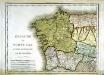
Espagne et Portugal, 1
1 Blatt : 31 x 42 cm Mentelle
Royaume de Portugal
1 : 7660000 Portugalsko Bonne, Rigobert André
Portugal
1 : 4300000 Fenner, Rest.


