Maps of Centro

Partie septentrionale du royaume de Portugal
1 Karte : Kupferdruck ; 47 x 52 cm Bellin; Santini; Remondini chez M. Remondini
Carta de Portugal, aprovada para uso das escolas / Direccâo Geral dos Trabalhos Geodesicos e Topographicos
1 : 500000 Direcçâo Geral dos Trabalhos Geodesicos e Topographicos
Regni Portugalliae provincias tres septentrionales Beiram, Transmontanam [et] Interamniam
1 Karte : Kupferdruck ; 53 x 44 cm Güssefeld; López Homann. haered
Parte septentrional do reyno de Portugal
1 Karte : Kupferdruck ; 40 x 52 cm Sanson em casa do autor
Il Portogallo cioè le provincie di Entre Douro, e Minho, Traz-Os-Montes, e Beira
1 Karte : Kupferdruck ; 30 x 40 cm Zatta Antonio Zatta
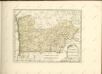
Partie septentrionale du royaume de Portugal
1 Karte : Kupferdruck ; 47 x 51 cm Robert de Vaugondy G. et D. Robert de Vaugondy
Regnorum Castellæ veteris Legionis et Gallæciæ principatuumque Biscaiæ et Asturiarum accuratissima descriptio, 1
1 Blatt : 48 x 41 cm Visscher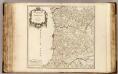
Portugal septentrionale.
1 : 680000 Robert de Vaugondy, Gilles, 1688-1766
Regnum Portugalliae divisum in quinque provincias majores & subdivisum in sua quaeque territoria una cum Regno Algabriae speciali mappa exhibitum
1 : 1050000 Algarve (Portugalsko) Homann, Johann Baptist H., H. per Ioh. Bapt. Homannum
REGNUM PORTUGALLIAE Divisum In Quinque Provincias majores & Subdivisum in sua quaeque Territoria una cum REGNO ALGARBIAE speciali mappa exhibitum
1 : 1050000 Portugalsko Homann, Johann Baptist Nolin, Jean-Baptiste per H. H.
Regnum Portugalliae divisum in quinque provincias majores & subdivisum in sua quaeque territoria una cum Regno Algarbiae speciali mappa exhibitum
1 : 1050000 Algarve (Portugalsko) Homann, Johann Baptist Nolin, Jean-Baptiste per H. H.
Portvgallia et Algarbia quae olim Lvsitania
1 : 1440000 Algarve (Portugalsko) Secco, Vernando Alvero Janssonius, Johannes apud Joannem Janßonnium
[Carte d'Espagne et de Portugal en neuf feuilles, 1]
1 Blatt : 31 x 41 cm P.G. Chanlaire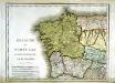
Espagne et Portugal, 1
1 Blatt : 31 x 42 cm Mentelle
Royaume de Portugal
1 : 7660000 Portugalsko Bonne, Rigobert André
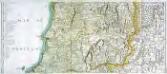
Mapa general del reyno de Portugal, 2
2 Blätter : 35 x 78 cm Tomás López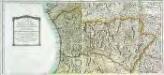
Mapa general del reyno de Portugal, 1
2 Blätter : 35 x 78 cm Tomás López

Mapa de la provincia de Entre Duero y Miño
1 Karte : Kupferdruck ; 32 x 27 cm López s.n.
Mappa ou carta geographica dos reinos de Portugal e Algarve, 1
1 Blatt : 55 x 44 cm Dury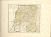

[Carte d'Espagne et de Portugal en neuf feuilles, 4]
1 Blatt : 31 x 41 cm P.G. Chanlaire
Espagne et Portugal, 4
1 Blatt : 31 x 42 cm Mentelle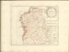

Gallæcia, regnvm
1 Karte : Kupferdruck ; 36 x 47 cm Ojea; Janssonius Joannes Janssonius
Gallæcia, regnvm
1 Karte : Kupferdruck ; 36 x 47 cm Ojea; Valck; Schenk apud Gerardum Valk et Petrum Schenk
Gallæcia, regnvm
1 Karte : Kupferdruck ; 37 x 49 cm Ojea; Blaeu apud Guilj. Blaeu
Mapa de la provincia de Tras-Los-Montes
1 Karte : Kupferdruck ; 32 x 27 cm López s.n.