Maps of Área Metropolitana do Porto


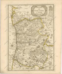
Mapa de la provincia de Entre Duero y Miño
1 Karte : Kupferdruck ; 32 x 27 cm López s.n.
Mappa ou carta geographica dos reinos de Portugal e Algarve, 1
1 Blatt : 55 x 44 cm Dury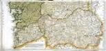
Mapa geográfico del reyno de Galicia, 2
2 Blätter : 41 x 85 cm s.n.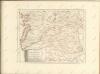

Portugal 1:100,000. 7
1 : 100000 Portugal. Direcção dos Trabalhos Geodesicos do Reino [Lisbonne] : Direcção Geral dos Trabalhos Geodesicos do Reino
Vigo
1 Plan : Kupferdruck ; 21 x 27 cm Allard; Allard chez Covens et Mortier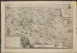
Caarte van de landingh inde Baaij van Vigos als meede het inneemen van twee Casteels en het verooveren der Spaansche silvre vloot ten ancker leggende inde Baaij voor Redondella den 23 en 24 october 1702
1 : 112000 geteekendt door L. du Mée, ordinaris Ingenjeur Jan v. Call fecit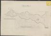
Port de Vigos
1 : 112000
Plan von Porto
Porto (Portugalsko) bei Winckelmann & Söhne
Entrance of the river Douro
Belcher, Edward
"Oporto. Porto. View of Oporto from Torre da Marca"
1 Mapa i 1 vista. Datat entre 1830 i 1839 aproximadament. W. B. Clarke
Regni Portugalliae provincias tres septentrionales Beiram, Transmontanam [et] Interamniam
1 Karte : Kupferdruck ; 53 x 44 cm Güssefeld; López Homann. haered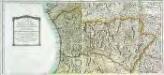
Mapa general del reyno de Portugal, 1
2 Blätter : 35 x 78 cm Tomás López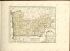

Pontevedra
1 : 200000 Coello, Francisco [Verlag nicht ermittelbar]

Charta geographica regnum Galæciam (hispanice Galicia) in suas provincias divisum repræsentans
1 Karte : Kupferdruck ; 44 x 52 cm Güssefeld; López per Homan. Hæredes in lucem edita
Orense
1 : 200000 Coello, Francisco [Verlag nicht ermittelbar]

Partie septentrionale du royaume de Portugal
1 Karte : Kupferdruck ; 47 x 52 cm Bellin; Santini; Remondini chez M. Remondini
Spain, Portugal 1.
1 : 1774080 Letts, Son & Co.
Regnorum Castellæ veteris Legionis et Gallæciæ principatuumque Biscaiæ et Asturiarum accuratissima descriptio, 1
1 Blatt : 48 x 41 cm Visscher
Spain. Espana I.
1 : 1800000 Society for the Diffusion of Useful Knowledge (Great Britain)
Portugal.
1 : 1800000 Society for the Diffusion of Useful Knowledge (Great Britain)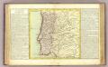
Portugal.
1 : 2150000 Clouet, J. B. L. (Jean-Baptiste Louis), b. 1730
[Carte d'Espagne et de Portugal en neuf feuilles, 1]
1 Blatt : 31 x 41 cm P.G. Chanlaire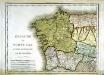
Espagne et Portugal, 1
1 Blatt : 31 x 42 cm Mentelle
Portugal, Azoren, Capverdischen Inseln.
1 : 2350000 Radefeld, Carl Christian Franz, 1788-1874