Maps of gmina Lubrza


[Kartenblatt]
1 : 25000 Morava (Česko) Reichsamt für Landesaufnahme
Meßtischblatt 3302 : Deutsch Rasselwitz, 1936
1 : 250000 Deutsch Rasselwitz. - Hrsg. 1884, einz. Nachtr. 1930, gedr. [19]36. - 1:25000. - [Berlin]: Reichsamt für Landesaufnahme, 1936. - 1 Kt.
Deutsch Paulowitz - m2784-2-001 - Kaiserpflichtexemplar der Landkarten des stabilen Katasters
1 : 2880
Deutsch Paulowitz - m2784-2-003 - Kaiserpflichtexemplar der Landkarten des stabilen Katasters
1 : 2880
Deutsch Paulowitz - m2784-2-002 - Kaiserpflichtexemplar der Landkarten des stabilen Katasters
1 : 2880
Deutsch Paulowitz - m2784-2-004 - Kaiserpflichtexemplar der Landkarten des stabilen Katasters
1 : 2880
Stubendorf - m2933-2-001 - Kaiserpflichtexemplar der Landkarten des stabilen Katasters
1 : 2880
Glemtau - m0709-1-005 - Kaiserpflichtexemplar der Landkarten des stabilen Katasters
1 : 2880
Glemtau - m0709-1-001 - Kaiserpflichtexemplar der Landkarten des stabilen Katasters
1 : 2880
Glemtau - m0709-1-002 - Kaiserpflichtexemplar der Landkarten des stabilen Katasters
1 : 2880
Glemtau - m0709-1-003 - Kaiserpflichtexemplar der Landkarten des stabilen Katasters
1 : 2880
Glemtau - m0709-1-004 - Kaiserpflichtexemplar der Landkarten des stabilen Katasters
1 : 2880
III. vojenské mapování 3859/4
1 : 25000
Meßtischblatt 5673 : Oberglogau, 1940
1 : 250000 Oberglogau. - Aufn. 1882, hrsg. 1883, bericht. 1937, letzte Nachtr. 1939, Ausg. 1940. - 1:25000. - [Berlin]: Reichsamt für Landesaufnahme, 1940. - 1 Kt.
Hotzenplotz - m2180-1-008 - Kaiserpflichtexemplar der Landkarten des stabilen Katasters
1 : 2880
Hotzenplotz - m2180-1-007 - Kaiserpflichtexemplar der Landkarten des stabilen Katasters
1 : 2880
Hotzenplotz - m2180-1-006 - Kaiserpflichtexemplar der Landkarten des stabilen Katasters
1 : 2880
Hotzenplotz - m2180-1-001 - Kaiserpflichtexemplar der Landkarten des stabilen Katasters
1 : 2880
Hotzenplotz - m2180-1-004 - Kaiserpflichtexemplar der Landkarten des stabilen Katasters
1 : 2880
Hotzenplotz - m2180-1-002 - Kaiserpflichtexemplar der Landkarten des stabilen Katasters
1 : 2880
Hotzenplotz - m2180-1-005 - Kaiserpflichtexemplar der Landkarten des stabilen Katasters
1 : 2880
Hotzenplotz - m2180-1-003 - Kaiserpflichtexemplar der Landkarten des stabilen Katasters
1 : 2880
Meßtischblatt 5671 : Neustadt O.S., 1935
1 : 250000 Neustadt O.S. - Hrsg. 1884, einz. Nachtr. 1930. - 1:25000. - [Berlin]: Reichsamt für Landesaufnahme, [19]35. - 1 Kt.
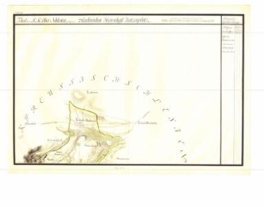
Hotzenplotz und Zuckmantel.
from Spezialkarte der osterreichisch-ungarischen Monarchie.
Umgebungen von Jägerndorf und die statistische Uebersicht
1 : 144000 K.K. Militärisches Geographisches Institut
III. vojenské mapování 3859
1 : 75000
III. vojenské mapování 3859
1 : 75000
Hotzenplotz und Zuckmantel
1 : 75000 Morava (Česko) Radler K. u. k. Militärgeographisches Institut