Maps of gmina Głuchołazy

Podrobná mapa Markrabství moravského a Vévodství slezkého
1 : 100000 Moravské markrabství Srp, Jan Jos. R. Vilímek
Hotzenplotz und Zuckmantel
1 : 75000 Morava (Česko) Radler K. u. k. Militärgeographisches Institut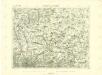
III. vojenské mapování 3859
1 : 75000
III. vojenské mapování 3859
1 : 75000
III. vojenské mapování 3858/4
1 : 25000
[Kartenblatt]
1 : 25000 Morava (Česko) Reichsamt für Landesaufnahme

III. vojenské mapování 3858/4
1 : 25000
[Kartenblatt]
1 : 25000 Jeseníky (Česko : pohoří) Reichsamt für Landesaufnahme
III. vojenské mapování 3859/3
1 : 25000
Meßtischblatt 5671 : Neustadt O.S., 1935
1 : 250000 Neustadt O.S. - Hrsg. 1884, einz. Nachtr. 1930. - 1:25000. - [Berlin]: Reichsamt für Landesaufnahme, [19]35. - 1 Kt.
Meßtischblatt 5670 : Ziegenhals, 1936
1 : 250000 Ziegenhals. - Hrsg. 1885, einz. Nachtr. 1930, gedr. [19]36. - 1:25000. - [Berlin]: Reichsamt für Landesaufnahme, 1936. - 1 Kt.
Meßtischblatt 3300 : Ziegenhals, 1912
1 : 250000 Ziegenhals. - Aufn. 1883, hrsg. 1885, Nachtr. [19]12. - 1:25000. - [Berlin]: Kgl. Preuss. Landesaufnahme, 1912. - 1 Kt.
Meßtischblatt 3299 : Kaindorf, 1936
1 : 250000 Kaindorf. - Hrsg. 1883, bericht. 1930, mehrfarb. Ausg. 1934, gedr. [19]36. - 1:25000. - [Berlin]: Reichsamt für Landesaufnahme, 1936. - 1 Kt.
III. vojenské mapování 3859/4
1 : 25000

[Kartenblatt]
1 : 25000 Morava (Česko) Reichsamt für Landesaufnahme
Meßtischblatt 5771 : Kunzendorf, 1936
1 : 250000 Kunzendorf. - Hrsg. 1884, einz. Nachtr. 1912. - 1:25000. - [Berlin]: Reichsamt für Landesaufnahme, [19]36. - 1 Kt.
Meßtischblatt 3344 : Arnoldsdorf, 1884
1 : 250000 Arnoldsdorf. - Aufn. 1883. - 1:25000. - [Berlin]: Kgl. Preuss. Landesaufnahme, 1884. - 1 Kt.
Meßtischblatt 5668 : Ober Hermsdorf, 1936
1 : 250000 Ober Hermsdorf. - Hrsg. 1883, kl. Nachtr. 1913. - 1:25000. - [Berlin]: Reichsamt für Landesaufnahme, 1936. - 1 Kt.
Meßtischblatt 3302 : Deutsch Rasselwitz, 1936
1 : 250000 Deutsch Rasselwitz. - Hrsg. 1884, einz. Nachtr. 1930, gedr. [19]36. - 1:25000. - [Berlin]: Reichsamt für Landesaufnahme, 1936. - 1 Kt.
Böhmischdorf (Morawska Diedina) - m0391-1-003 - Kaiserpflichtexemplar der Landkarten des stabilen Katasters
1 : 2880
Böhmischdorf (Morawska Diedina) - m0391-1-001 - Kaiserpflichtexemplar der Landkarten des stabilen Katasters
1 : 2880
Böhmischdorf (Morawska Diedina) - m0391-1-004 - Kaiserpflichtexemplar der Landkarten des stabilen Katasters
1 : 2880
Böhmischdorf (Morawska Diedina) - m0391-1-002 - Kaiserpflichtexemplar der Landkarten des stabilen Katasters
1 : 2880
Böhmischdorf (Morawska Diedina) - m0391-1-007 - Kaiserpflichtexemplar der Landkarten des stabilen Katasters
1 : 2880
Böhmischdorf (Morawska Diedina) - m0391-1-011 - Kaiserpflichtexemplar der Landkarten des stabilen Katasters
1 : 2880
Böhmischdorf (Morawska Diedina) - m0391-1-010 - Kaiserpflichtexemplar der Landkarten des stabilen Katasters
1 : 2880
Böhmischdorf (Morawska Diedina) - m0391-1-012 - Kaiserpflichtexemplar der Landkarten des stabilen Katasters
1 : 2880
Böhmischdorf (Morawska Diedina) - m0391-1-005 - Kaiserpflichtexemplar der Landkarten des stabilen Katasters
1 : 2880
Böhmischdorf (Morawska Diedina) - m0391-1-009 - Kaiserpflichtexemplar der Landkarten des stabilen Katasters
1 : 2880
Böhmischdorf (Morawska Diedina) - m0391-1-008 - Kaiserpflichtexemplar der Landkarten des stabilen Katasters
1 : 2880


