Maps of Rosendahl

Meßtischblatt 2141 : Horstmar, 1935
1 : 250000 Horstmar. - Hrsg. 1897, einz. Nachtr. 1926. - 1:25000. - [Berlin]: Reichsamt für Landesaufnahme, 1935. - 1 Kt.
Meßtischblatt 2141 : Horstmar, 1897
1 : 250000 Horstmar. - Aufn. 1895. - 1:25000. - [Berlin]: Reichsamt für Landesaufnahme, 1897. - 1 Kt.
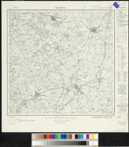
Composite: 305. Ahaus.
1 : 100000 Reichsamt fur Landesaufnahme
305. Ahaus.
1 : 100000 Reichsamt fur Landesaufnahme
35 Ahaus, uit: Topographische en militaire kaart van het Koningrijk der Nederlanden / vervaardigd door de officieren van den Generale Staf ; en gegraveerd op het Topographisch Bureau, van het Ministerie van Oorlog
1 : 50000 titelvariant: TMK; Annotatie: Met bladwijzer op schaal 1:600.000. - 1915; Met Verklaring van de topographische en militaire kaart van het Koninkrijk der Nederlanden. - 1910; Bd. 1: titelblad, bladwijzer, verklaring, bladen 1 t/m 32; Bd. 2: bladen 33 t/m 62 Generale Staf, Nederland; Ministerie van Oorlog. Topographisch Bureau ['s-Gravenhage : Ministerie van Oorlog]
16me Oldenzaal, uit: [Nouvelle carte de la Hollande, d'après Kraijenhoff et les meilleures cartes connus] / [Ph. Vandermaelen]
1 : 130000 Annotatie: Ontbreekt: bl. 1-12 Vandermaelen, Philippe Marie Guillaume Bruxelles : Établissement Géographique

COMITATVS | BENTHEIM, | et | STEINFVRT.
Auctore | Ioanne Westenberg | M. Doct. et Math. Guljelm. Blaeu excudebat
Comitatus Bentheim, et Steinfurt. [Karte], in: Theatrum orbis terrarum, sive, Atlas novus, Bd. 1, S. 212.
1 Karte aus Atlas Blaeu, Joan Blaeu, Willem Janszoon
Comitatus Bentheim, et Steinfurt. [Karte], in: Novus Atlas, das ist, Weltbeschreibung, Bd. 1, S. 132.
1 Karte aus Atlas Blaeu, Joan Blaeu, Willem Janszoon
Central Europe 1:1,000,000, Bocholt
Sheet P1 of the 287 sheet series: Central Europe. 1 : 100,000. G.S.G.S. No. 4416. AMS. M641, M651, M671. [London?] ; Washington, D.C. : War Office : Army Map Service, U.S. Army.
Comitatus Bentheim, et Steinfurt. [Karte], in: Novus atlas absolutissimus, Bd. 2, S. 121.
1 Karte aus Atlas Janssonius Offizin
Comitatus Bentheim, et Steinfurt. [Karte], in: Le théâtre du monde, ou, Nouvel atlas contenant les chartes et descriptions de tous les païs de la terre, Bd. 1, S. 163.
1 Karte aus Atlas Blaeu, Willem Janszoon und Blaeu, Joan Blaeu, Willem Janszoon
Comitatus Bentheim, et Steinfurt / auctore Ioanne Westenberg ; [Willem Jansz. Blaeu]
1 : 230000 Annotatie: Het eerst verschenen in: Ander Theil Novi Atlantis ... - Amsterdami : apud Guiljelmum et Johannem Blaeu, 1635; Origineel is Blad 78 in atlas factice; Annotatie geografische gegevens: Oost boven Westenberg, Johannes; Blaeu, Willem Jansz. [Amsterdam : Guljelm. Blaeu excudebat]
Comitatus Bentheimensis Nova Descriptio [Karte], in: Gerardi Mercatoris et I. Hondii Newer Atlas, oder, Grosses Weltbuch, Bd. 1, S. 173.
1 Karte aus Atlas Mercator, Gerhard und Hondius, Jodocus Jansson, Jan
Zwolle 56, uit: [W. Liebenow's Special-Karte von Mittel-Europa]
1 : 300000 titelvariant: W. Liebenow's Mittel-Europa; Annotatie: Titel boven de bladen: W. Liebenow's Mittel-Europa Johannes Wilhelm Liebenow 1822-1897 Hannover : Hermann Oppermann
(No. VIII), uit: Choro-topographische kaart der Noordelijke Provinciën van het Koningrijk der Nederlanden / uitgevoerd aan het Topographisch Bureau van dezen Staat, volgens het ontwerp, de geodesische en astronomische waarnemingen van Baron Kraijenhoff
1 : 115200 Annotatie: Gestempeld r.o. in rood: AVO (=Archief van Oorlog); Lit.: J.A. van der Linden, Topographische en militaire kaart van het Koningrijk der Nederlanden. Bussum 1973. p. 9-16 & E. ten Brink, De grote kaart van Krayenhoff, speciaal p. 38-39; Op de bladwijzer staat de Hoofddriehoeksmeting aangegeven met de Alphabetische tafel der breedte en lengte van de standplaatsen; Annotatie geografische gegevens: Schaalstok van 27,77 Mylen (Kilomètres) of 7380 Rh. Roeden of 5 Uren (=23,7 cm), op schaal: 800 Rl. Roeden op den Rh. Duim of van 1,152 Myl (Kilomètre) op den Duim (Centimètre); Legenda r.o. op blad VII Topographisch Bureau, Den Haag; Archief van Oorlog, Den Haag ['s-Gravenhage : Topographisch Bureau, Archief van Oorlog]
[12], uit: Hydro-Oro und Chorographische General Karte des Koenigreichs der Niederlande und der angrenzenden Länder bis Paris : mit der Angabe der Kunst und Heer-Strassen und der Entfernung der Poststationen / ... zusammengetragen und reducirt von ... Wilhelm Müller
1 : 400000 titelvariant: Generalkarte des Koenigreichs Hannover; Annotatie: 1e supplement bij: Generalkarte des Koenigreichs Hannover (1818) Müller, Wilhelm (fl. 1818) [Hannover : Wilhelm Müller]
Zwolle 56, uit: Special-Karte von Mittel-Europa / nach amtlichen Quellen bearbeitet von W. Liebenow
1 : 300000 titelvariant: W. Liebenow's Mittel-Europa; Annotatie: Titel boven de bladen: W. Liebenow's Mittel-Europa Johannes Wilhelm Liebenow 1822-1897 Frankfurt a. M. : Ludwig Ravenstein

Episcopatvs Monasteriensis Pars Avstralis
1 : 290000 Mollova mapová sbírka Gigas, Johann Michael
Episcopatvs Monasteriensis Pars Avstralis
1 : 290000 Mollova mapová sbírka Gigas, Johann Michael
Carte topographique d'Allemagne
1 : 225000 Dortmund (Německo) Facius, Johann Gottlieb ches I.W.A. Iaeger
[Kaart], uit: Wandel- en fietskaart van Rijssen en omstreken
1 : 18750 Rijssen : Vereeniging tot Bevordering van het Marktwezen en Plaatselijke Belangen in Rijssen
Haute Partie De L'Evesché De Munster subdivisé en ses principales Iuridictions. [Karte], in: Atlas nouveau, contenant toutes les parties du monde [...], Bd. 1, S. 303.
1 Karte aus Atlas Sanson, Nicolas Jaillot, Alexis Hubert und Mortier, Pieter
Haute Partie de l'Evesché de Munster subdivisé en ses principales Iuridictios
1 : 300000 Mollova mapová sbírka Sanson, Guillaume Jaillot, Alexis Hubert
La Seigneurie D'Over-Yssel subdivisée en Trois Parties Sallant, Twente, et Drente [Karte], in: Atlas nouveau, contenant toutes les parties du monde [...], Bd. 2, S. 83.
1 Karte aus Atlas Sanson, Nicolas Jaillot, Alexis Hubert und Mortier, Pieter
Clivia ducatus / [Joannes Janssonius]
1 : 250000 Annotatie: Het eerst verschenen in: Gerardi Mercatoris et I. Hondii appendix atlas ... - Ambsterdam : bey Johan Jansson, 1636; Origineel is Blad 64 in atlas factice; Annotatie geografische gegevens: Noordoost boven Janssonius, Joannes (jr.) (1588-1664) [Amsterdam : Joannes Janssonius]
Monasteriensis et Osnabvrgensis Episcopatvs
1 : 490000 Mollova mapová sbírka Maschop, Gottfried