Maps of Regierungsbezirk Münster

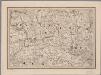
Monasteriensis et Osnabvrgensis Episcopatvs
1 : 490000 Mollova mapová sbírka Maschop, Gottfried
Rev.mo et Seren.mo Principi ac Domo. Dn. Ferdinando Archiep. et Elect. Colon. Episcop. Monasteriens Leto, Duci Bavariae
Mollova mapová sbírka Gigas, Johann Michael
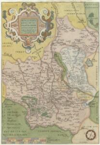
MONASTERIENSIS | Episcopatus
Judocus Hondius excudit.
Carta del vescovato di Mvnster
1 : 480000 Münster in Westfalen-oblast (Německo) Bouttats, Gerhaert Hacque, Johann Baptist
Carta del vescovato di Mvnster
1 : 480000 Münster in Westfalen-oblast (Německo) Bouttats, Gerhaert Hacque, Johann Baptist
Monasteriensis episcopatvs
1 : 485000 Münster in Westfalen-oblast (Německo) Janssonius, Johannes apud Ioannem Ianßonium
Monasteriensis episcopatus
1 : 485000 Münster in Westfalen-oblast (Německo) Gigas, Johann Michael Blaeu, Willem Janszoon apud Guiljelmum Blaeuw
Monasteriensis Episcopatus. [Karte], in: Theatrum orbis terrarum, sive, Atlas novus, Bd. 1, S. 209.
1 Karte aus Atlas Blaeu, Joan Blaeu, Willem Janszoon
Monasteriensis Episcopatus. [Karte], in: Le théâtre du monde, ou, Nouvel atlas contenant les chartes et descriptions de tous les païs de la terre, Bd. 1, S. 160.
1 Karte aus Atlas Blaeu, Willem Janszoon und Blaeu, Joan Blaeu, Willem Janszoon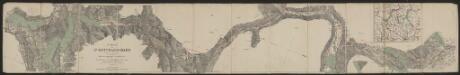
Monasteriensis Episcopatus. [Karte], in: Gerardi Mercatoris et I. Hondii Newer Atlas, oder, Grosses Weltbuch, Bd. 1, S. 164.
1 Karte aus Atlas Mercator, Gerhard und Hondius, Jodocus Jansson, Jan
Monasteriensis Episcopatus. [Karte], in: Novus atlas absolutissimus, Bd. 2, S. 118.
1 Karte aus Atlas Janssonius Offizin
Carte Nouvelle de l'Eveché de Munster
1 : 180000 Mollova mapová sbírka Grancourt
Territorium Seculare Episcopatvs Monasterii Mvnster Germanis dicti
1 : 420000 Mollova mapová sbírka Homann, Johann Baptist Homann, Johann Baptista - dědici
Monasteriensis et Osnabvrgensis episcopatvs descriptio
1 Karte : Kupferdruck ; 36 x 25 cm Mascop; Ortelius s.n.
Monasteriensis et Osnabvrgensis episcopatvs descriptio
1 Karte : Kupferdruck ; 25 x 36 cm Mascop; Ortelius s.n.
Monasteriensis Episcopatvs
1 : 470000 Mollova mapová sbírka Schenk, Pieter Schenk, Peter I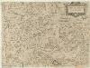
Carta del Vescovato di Mvnster
1 : 450000 Mollova mapová sbírka Hacque, Johann Baptist
Monasteriensis Episcopatus
1 : 460000 Mollova mapová sbírka Hondius, Jodocus Hondius, Jodocus
Monasteriensis Episcopatvs
1 : 460000 Mollova mapová sbírka Gigas, Johann Michael Blaeu, Joan I.
Monasteriensis Episcopatus
1 : 460000 Mollova mapová sbírka Gigas, Johann Michael Blaeu, Willem Jansz.
Haute Partie de l'Evesché de Munster subdivisé en ses principales Iuridictios
1 : 300000 Mollova mapová sbírka Sanson, Guillaume Jaillot, Alexis Hubert
Episcopatvs Monasteriensis Pars Avstralis
1 : 290000 Mollova mapová sbírka Gigas, Johann Michael
Episcopatvs Monasteriensis Pars Avstralis
1 : 290000 Mollova mapová sbírka Gigas, Johann Michael
Haute Partie De L'Evesché De Munster subdivisé en ses principales Iuridictions. [Karte], in: Atlas nouveau, contenant toutes les parties du monde [...], Bd. 1, S. 303.
1 Karte aus Atlas Sanson, Nicolas Jaillot, Alexis Hubert und Mortier, Pieter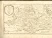
[12], uit: Hydro-Oro und Chorographische General Karte des Koenigreichs der Niederlande und der angrenzenden Länder bis Paris : mit der Angabe der Kunst und Heer-Strassen und der Entfernung der Poststationen / ... zusammengetragen und reducirt von ... Wilhelm Müller
1 : 400000 titelvariant: Generalkarte des Koenigreichs Hannover; Annotatie: 1e supplement bij: Generalkarte des Koenigreichs Hannover (1818) Müller, Wilhelm (fl. 1818) [Hannover : Wilhelm Müller]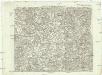
Carte topographique d'Allemagne
1 : 225000 Dortmund (Německo) Facius, Johann Gottlieb ches I.W.A. Iaeger
Osnabrugensis Episcopatus. [Karte] Districtus Reckenbergensis. [Nebenkarte], in: Gerardi Mercatoris et I. Hondii Newer Atlas, oder, Grosses Weltbuch, Bd. 1, S. 170.
1 Karte aus Atlas Mercator, Gerhard und Hondius, Jodocus Jansson, Jan