Maps of Schnelldorf

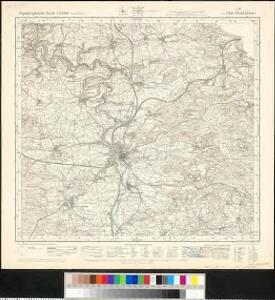
Meßtischblatt 6826 : Crailsheim, 1938
1 : 250000 Crailsheim. - 1:25000. - Stuttgart, 1938. - 1 Kt.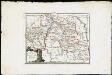
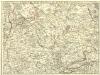
Die Freye Reichsstadt Schwaebisch Hall mit ihrem Gebiethe : Nro. 190
Reilly, Franz Johann Joseph von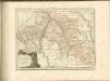

Tabula geographica sistens territorivm liberæ sacri romani imperii civitatis Svevo=Hallensis
1 Karte : Kupferdruck ; 45 x 54 cm Cnopf Homännische Erben
162. Rothenburg a.d. Thauber, uit: Topographische Uebersichtskarte des Deutschen Reiches / herausgegeben v. d. Kartogr. Abt. d. Königl. Preuß. Landesaufnahme
1 : 200000 titelvariant: Topogr. Übersichtskarte des Deutschen Reiches; Annotatie: Titel boven bladen ook: Topogr. Übersichtskarte des Deutschen Reiches; Annotatie geografische gegevens: Op elk blad twee maatstokken: 10 Kilometer = 5,5 cm; 1 geogr. Meile = 3,6 cm; Legenda onder op elk blad Königlich Preußische Landesaufnahme. Kartographische Abtheilung [S.l : Königlich Preußische Landesaufnahme, Kartographische Abtheilung]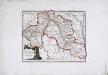
Die freye Reichsstadt Schwæbisch Hall mit ihrem Gebiethe
1 Karte : Kupferdruck ; 21 x 27 cm Reilly F. J. J. von Reilly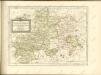

Charte von dem Fürstenthum Hohenlohe, und der Grafschafft Limpurg
1 : 150000 Hohenlohe (Německo) Hammer, C.F.
Serenissimis Principibvs ac Dominis ab Hohenloh. Dynastis in Langenburg
1 : 170000 Mollova mapová sbírka Chapuset, Johann Karl Homann, Johann Baptista - dědici
Serenissimis Principibvs ac Dominis ab Hohenloh. Dynastis in Langenburg
1 : 170000 Mollova mapová sbírka Chapuset, Johann Karl Homann, Johann Baptista - dědici
Serenissimis principibvs ac dominis ab Hohenloh, dynastis in Langenburg nec non celsissimis comitibvs ac dominis ab Hohenloh. et Gleichen, dynastis in Langenb. et Cranchfeld etc
1 : 170000 Bádensko (Německo) Chapuset, Johann Karl excudentib. Homannianis Heredibus
Serenissimis principibvs ac dominis ab Hohenloh, dynastis in Langenburg nec non celsissimis comitibvs ac dominis ab Hohenloh. et Gleichen, dynastis in Langenb. et Cranchfeld etc
1 : 170000 Bádensko (Německo) Chapuset, Johann Karl excudentib. Homannianis Heredibus
Serenissimis principibvs ac dominis ab Hohenloh, dynastis in Langenburg nec non celsissimis comitibvs ac dominis ab Hohenloh. et Gleichen, dynastis in Langenb. et Cranchfeld etc
1 : 170000 Bádensko (Německo) Chapuset, Johann Karl excudentib. Homannianis Heredibus
Serenissimis principibvs ac dominis ab Hohenloh, dynastis in Langenburg nec non celsissimis comitibvs ac dominis ab Hohenloh. et Gleichen, dynastis in Langenb. et Cranchfeld etc
1 : 170000 Bádensko (Německo) Chapuset, Johann Karl excudentib. Homannianis Heredibus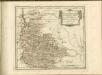

Suevia Universa :
1 : 170000 Mollova mapová sbírka Michal, Jacques de Seutter, Matthäus Seutter, Matthäus
Suevia universa IX. tabulis delineata, 2
1 Blatt : s.n.
Des Herzogthums Würtemberg nordöstliche Aemter mit den freyen Reichsstädten Heilbronn, Wimpfen und Eslingen
1 Karte : Kupferdruck ; 23 x 26 cm Reilly F. J. J. von Reilly
continent Partem Marchion: Onoldin: Palat: Sultzbac: Neoburg: Episc: Aichstad: Reipubl: Norimberg: et insertas Regîones
1 : 150000 Mollova mapová sbírka Buna, Wilhelm C. Broenner, Heinrich Ludwig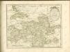

Le Theatre de Bellone :
Mollova mapová sbírka Schenk, Pieter Braakman, Adriaan
Generalkarte von Württemberg: Blatt II
1 : 1500000 Terrainzeichnung: Bach, Topograf und Hauptmann Lithografie: Rebmann und Sommer Herausgeber: K. statistisch-topografisches Büro
Mappa Geographica exhibens Principatvm Brandenbvrgico Onolsbacensem, una cum finitimis Regionibus Terrisque
1 : 260000 Mollova mapová sbírka Cnopf, Matthäus Ferdinand Hauer, Daniel Adam Homann, Johann Baptista - dědici
Le Theatre de la Guerre Sur le Haut Rhein
1 : 142000 Mollova mapová sbírka Sanson, Guillaume
Carte topographique d'Allemagne contenant la Franconie sçavoir une partie des evechés de Wurzbourg de Bamberg
1 Karte : Kupferdruck ; 46 x 62 cm Jaeger; Facius se vend chés l'auteur
Tabula Geographica Nova exhibens Partem Infra Montanam Burggraviatus Norimbergensis Sive Principatum Onolsbacensem cum Terris Limitaneis Accurate delineatam
1 : 140000 Mollova mapová sbírka Vetter, Johann Georg Windter, Johann W. Vetter, Johann Georg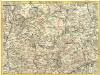
Pars Sueviae Borealior
1 : 250000 Mollova mapová sbírka Delisle, Guillaume Wolff, Jeremias
Nova et accuratißima Ducatus Wurtenbergici
1 : 300000 Mollova mapová sbírka Seutter, Matthäus Seutter, Matthäus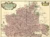
Carte tres Particuliere du Duché de Wirtemberg
1 : 240000 Mollova mapová sbírka Fer, Nicolas de Loon, Herman van L'Isle, Guillaume de
Partie Meridionale de la Souabe
1 : 250000 Mollova mapová sbírka Delisle, Guillaume Cordier, Louis L'Isle, Guillaume de