Maps of Middle Franconia

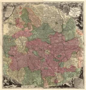
Tabula Geographica Nova exhibens Partem Infra Montanam Burggraviatus Norimbergensis Sive Principatum Onolsbacensem cum Terris Limitaneis Accurate delineatam
1 : 140000 Mollova mapová sbírka Vetter, Johann Georg Windter, Johann W. Vetter, Johann Georg
Mappa Geographica exhibens Principatvm Brandenbvrgico Onolsbacensem, una cum finitimis Regionibus Terrisque
1 : 260000 Mollova mapová sbírka Cnopf, Matthäus Ferdinand Hauer, Daniel Adam Homann, Johann Baptista - dědici
Tabula Geographica Nova exhibens Partem Infra Montanam Burggraviatus Norimbergensis Sive Principatum Onolsbacensem cum Terris Limitaneis Accurate delineatam
1 : 140000 Mollova mapová sbírka Vetter, Johann Georg Kauffer, Michael

Karte vom Fürstenthum Anspach oder Onolzbach oder Burggrafthum Unterhalb des Gebürges (Principatus Onoldinus)
1 : 200000 Ansbach (Německo) Schropp, Simon F.G. Baumgartenschen Buchhandulng
Carte topographique d'Allemagne contenant la Franconie sçavoir une partie des evechés de Wurzbourg de Bamberg
1 Karte : Kupferdruck ; 46 x 62 cm Jaeger; Facius se vend chés l'auteur
Marchionatus Onoldini Comitatus Oettingensis Praepositurae Elevacensis et Pappenheimensis, Dynastiarum in hoc terrae tractu, comprehentarum nova delineatio Geographica
1 : 220000 Mollova mapová sbírka Seutter, Matthäus Lotter, Tobias Conrad Seutter, Matthäus
Per Inclyti Circuli Suevici Supremorum Ordinum
1 : 160000 Mollova mapová sbírka Pfeffel, Johann Andreas Homann, Johann Baptista - dědici
Geographica provinciarum Sueviae descriptio, 2
4 Blätter : Johann Georg Bodenehr
continent Partem Marchion: Onoldin: Palat: Sultzbac: Neoburg: Episc: Aichstad: Reipubl: Norimberg: et insertas Regîones
1 : 150000 Mollova mapová sbírka Buna, Wilhelm C. Broenner, Heinrich Ludwig
S. R. I. Principatus et Episcopatus Eistettensis
1 : 160000 Mollova mapová sbírka Homann, Johann Baptist Homann, Johann Baptista
Tabulae Geographicae Principatus Brandenburg: Culmb: sive Baruthini Pars Inferior cum adjacentibus Regionibus exhibita et Sculpta
1 : 150000 Mollova mapová sbírka Seutter, Matthäus Seutter, Matthäus
Geographica Provinciarum Sveviae Descriptio =
Mollova mapová sbírka Hurter, Johann Christoph Bodenehr, Gabriel
163. Nürnberg, uit: Topographische Uebersichtskarte des Deutschen Reiches / herausgegeben v. d. Kartogr. Abt. d. Königl. Preuß. Landesaufnahme
1 : 200000 titelvariant: Topogr. Übersichtskarte des Deutschen Reiches; Annotatie: Titel boven bladen ook: Topogr. Übersichtskarte des Deutschen Reiches; Annotatie geografische gegevens: Op elk blad twee maatstokken: 10 Kilometer = 5,5 cm; 1 geogr. Meile = 3,6 cm; Legenda onder op elk blad Königlich Preußische Landesaufnahme. Kartographische Abtheilung [S.l : Königlich Preußische Landesaufnahme, Kartographische Abtheilung]
Tabulae geographicae principatus Brandenburg. Culmb. sive Baruthini
1 : 179600 Bavorsko severní (Německo) Lotter, Tobias Conrad Tob. Conrad Lotter
Das Nürenbergische Gebiet mit allen Nürnbergischen Hauptmannschafften
1 : 200000 Norimberk-oblast (Německo) Scheurer, Christoph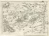
Geographica Provinciarum Sveviae Descriptio =
Mollova mapová sbírka Hurter, Johann Christoph Bodenehr, Johann Georg
Das Nürenbergische Gebiet
1 : 200000 Mollova mapová sbírka Scheurer, Christoph Seutter, Matthäus
Das Nürenbergische Gebiet
1 : 200000 Mollova mapová sbírka Scheurer, Christoph Seutter, Matthäus
S. R. I. principatus et episcopatus Eistettensis cum omnibus suis praefecturis et pertinentiis, tam in proprio, quam in alieno territorio vicinorum statuum sitis
1 : 168000 Bavorsko (Německo) Homann, Johann Baptist Homannovi dědicové
Episcopatus Aichstettensis, cum dynastiis et praefecturis suis ac viciniis hac geographica delineatione accuratè descriptus
1 : 180000 Mollova mapová sbírka Seutter, Matthäus Lotter, Tobias Conrad Seutter, Matthäus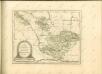

Principatus Brandenbvrgico Cvlmbacensis vel Barvthini
1 : 120000 Mollova mapová sbírka Cnopf, Matthäus Ferdinand Homann, Johann Baptista - dědici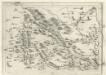
Geographica Provinciarum Sveviae Descriptio :
Mollova mapová sbírka Hurter, Johann Christoph Küsel, Melchior Bodenehr, Johann Georg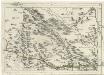
Geographica Provinciarum Sveviae Descriptio =
Mollova mapová sbírka Hurter, Johann Christoph Bodenehr, Gabriel
Bairische Landtafeln XXIIII. Darinnē das hochlöblich Furstenthumb Obern unnd Nidern Bayrn sambt der Obern Pflaz Erz unnd Stifft Salzburg Eichstet unnd andern mehrern anstossenden Herschafftē]
1 : 145000 Mollova mapová sbírka Apian, Philipp Amman, Jost Apian, Petrus
Nova Comitatus Pappenheimensis Tabula
1 : 80000 Mollova mapová sbírka Homann, Johann Baptist Homann, Johann Baptista - dědici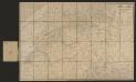
Territorium Norimbergense. [Karte] Nurnberg [Planvedute, Nebenkarte], in: Gerardi Mercatoris et I. Hondii Newer Atlas, oder, Grosses Weltbuch, Bd. 1, S. 310.
1 Karte aus Atlas Mercator, Gerhard und Hondius, Jodocus Jansson, Jan
Territorium Norimbergense. [Karte] Nurnberg., in: Novus Atlas, das ist, Weltbeschreibung, Bd. 1, S. 228.
1 Karte aus Atlas Blaeu, Joan Blaeu, Willem Janszoon