Maps of Berlin

Meßtischblatt 3445 : Spandau, 1945
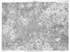
1 : 250000 Spandau. - Aufn. 1901 und 1927/34, bericht. 1936, hrsg. 1936, redakt. Änd. 1938. Gebäudeschäden im Gebiet der Stadt Berlin / Stand 1945. - 1:25000. - [Berlin]: Reichsamt für Landesaufnahme, 1945. - 1 Kt.
Meßtischblatt 3445 : Spandau, 1938
1 : 250000 Spandau. - Aufn. 1901 und 1927/34, bericht. 1936, hrsg. 1936, redakt. Änd. 1938. - 1:25000. - [Berlin]: Reichsamt für Landesaufnahme, 1938. - 1 Kt.
Meßtischblatt 1836 : Spandau, 1936
1 : 250000 Spandau. - Aufn. 1927/34, bericht. 1936. - 1:25000. - [Berlin]: Reichsamt für Landesaufnahme, 1936. - 1 Kt.
Meßtischblatt 1836 : Charlottenburg, 1920
1 : 250000 Charlottenburg. - Aufn. 1901, hrsg. 1903, bericht. 1920. - 1:25000. - [Berlin]: Reichsamt für Landesaufnahme, 1920. - 1 Kt.
Meßtischblatt 1836 : Charlottenburg, 1918
1 : 250000 Charlottenburg. - Aufn. 1901, hrsg. 1903, B. 06, N. 13, N. 417, Aufldr. 1918. - 1:25000. - [Berlin]: Reichsamt für Landesaufnahme, 1918. - 1 Kt.
Plan de Spandau
Mollova mapová sbírka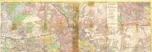
Taschenplan von Berlin
Plan von Berlin
1 : 25000 Berlín (Německo) Morin, F. H. F.H. Morin
Blatt VI Berlin, uit: Karte von Berlin und Umgebung in 12 Blättern
1 : 50000 Annotatie: Toelichtingen opgeborgen bij kaart; Annotatie geografische gegevens: Met schaalstokken: Meter, Schritt, geographische Meile Paul Schneider Berlin : Reichsamt für Landesaufnahme
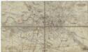
Umgebung von Berlin

268. Spandau.
1 : 100000 Reichsamt fur Landesaufnahme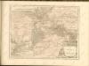

Composite: 268. Spandau.
1 : 100000 Reichsamt fur Landesaufnahme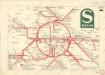
S Bahn
Berlin (1944)
Germany. Berlin. Scale, 1: 59,000 (approx.). Copied from a German map dated 1931. G.S.G.S. (Misc.) No.168. [London] : War Office
Berlin unter alliierter Verwaltung 1.9.1945
Berlin Kunz, Andreas ; Moeschl, Joachim Robert
Neuer geometrischer Plan der gesammten königlich-preussischen und churfürstlich-brandenburgischen Haupt und Rezidnez Stadt Berlin
1 : 79000 Berlín (Německo) Lotter, Tobias Conrad Tobias Conrad Lotter
Großer Silva-Stadtplan von Berlin
1 : 23000 Berlín (Německo) Verlag für heimatliche Kultur Willy Holz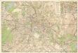
Strassenübersichtsplan von Berlin

Grundriss von Berlin
Berlín (Německo) Herzberg Veit Veit et Comp.
Plan von Berlin

[Kaart], uit: Silva-Stadtplan Berlin
1 : 22000 titelvariant: Berlin; Stadtplan von Berlin; Annotatie: Titel ook te lezen als: Berlin; Titel op omslag: Stadtplan von Berlin : im Gebiet der Stadt-Ringbahn mit Straßenverzeichnis u. Führer durch Berlins Museen u. Sehenswürdigkeiten; Editievermelding op omslag: Ausg. A 5; Verso: straatnamenregister Berlin : Verlag für Heimatliche Kultur Willy Holz
Pharus-Plan Berlin
1 : 28000 Berlín (Německo) Pharus Verlag
Pharus-Plan Berlin
Löwe, Cornelius
Stadtplan Berlin
1 : 20000 Annotatie: Afkomstig uit: Berlin. - 1923. - (Griebens Reiseführer ; Bd. 6); Een deel van de titel ontbreekt Berlin : Grieben
Pharus-Plan Berlin
1 : 18750 Berlin : Pharus-Verlag
Gegend zwischen Spandau und Nauen
1 : 160000 Špandava (Berlín, Německo)
Die Königl. Residenz Berlin
1 : 8500 Mollova mapová sbírka Schleuen, Johann David Schleuen, Johann David
Die Churfürstlich-Brandenburgisch nun Königlich-Preüssische Residenz-Statt Berlin und Cölln an der Spree :
Mollova mapová sbírka Bodenehr, Gabriel Bodenehr, Gabriel
Pharus-Plan Berlin
1 : 25000 Berlín (Německo) Pharus-Verlag


