Maps of Schönwalde-Glien

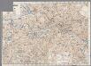
268. Spandau.
1 : 100000 Reichsamt fur Landesaufnahme
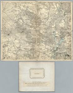
Composite: 268. Spandau.
1 : 100000 Reichsamt fur Landesaufnahme
Gegend zwischen Spandau und Nauen
1 : 160000 Špandava (Berlín, Německo)
Meßtischblatt 3445 : Spandau, 1945
1 : 250000 Spandau. - Aufn. 1901 und 1927/34, bericht. 1936, hrsg. 1936, redakt. Änd. 1938. Gebäudeschäden im Gebiet der Stadt Berlin / Stand 1945. - 1:25000. - [Berlin]: Reichsamt für Landesaufnahme, 1945. - 1 Kt.
Meßtischblatt 3445 : Spandau, 1938
1 : 250000 Spandau. - Aufn. 1901 und 1927/34, bericht. 1936, hrsg. 1936, redakt. Änd. 1938. - 1:25000. - [Berlin]: Reichsamt für Landesaufnahme, 1938. - 1 Kt.
Meßtischblatt 1836 : Spandau, 1936
1 : 250000 Spandau. - Aufn. 1927/34, bericht. 1936. - 1:25000. - [Berlin]: Reichsamt für Landesaufnahme, 1936. - 1 Kt.
Meßtischblatt 1836 : Charlottenburg, 1920
1 : 250000 Charlottenburg. - Aufn. 1901, hrsg. 1903, bericht. 1920. - 1:25000. - [Berlin]: Reichsamt für Landesaufnahme, 1920. - 1 Kt.
Meßtischblatt 1836 : Charlottenburg, 1918
1 : 250000 Charlottenburg. - Aufn. 1901, hrsg. 1903, B. 06, N. 13, N. 417, Aufldr. 1918. - 1:25000. - [Berlin]: Reichsamt für Landesaufnahme, 1918. - 1 Kt.
Meßtischblatt 1835 : Dallgow- Döberitz, 1937
1 : 250000 Dallgow- Döberitz. - Hrsg. 1903, bericht. 1925, mehrfarb. Ausg. 1936, einz. Nachtr. 1937. - 1:25000. - [Berlin]: Reichsamt für Landesaufnahme, 1937. - 1 Kt.
Meßtischblatt 1835 : Dallgow- Döberitz, 1920
1 : 250000 Dallgow- Döberitz. - Aufn. 1901, bericht. 1920. - 1:25000. - [Berlin]: Reichsamt für Landesaufnahme, 1920. - 1 Kt.
Meßtischblatt 1835 : Dallgow- Döberitz, 1911
1 : 250000 Dallgow- Döberitz. - Aufn. 1901, hrsg. 1903, bericht. 1906, einzelne Nachtr. 1911. - 1:25000. - [Berlin]: Reichsamt für Landesaufnahme, 1911. - 1 Kt.
Meßtischblatt 3345 : Hennigsdorf, 1938
1 : 250000 Hennigsdorf. - Hrsg. 1903, bericht. 1919, redakt. Änd. [19]38. - 1:25000. - [Berlin]: Reichsamt für Landesaufnahme, 1938. - 1 Kt.
Meßtischblatt 3344 : Marwitz, 1941
1 : 250000 Marwitz. - Aufn. 1901, hrsg. 1903, bericht. 1920, letzte Nachtr. 1940. - 1:25000. - [Berlin]: Reichsamt für Landesaufnahme, 1941. - 1 Kt.
Plan de Spandau
Mollova mapová sbírka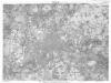
Berlin (1944)
Germany. Berlin. Scale, 1: 59,000 (approx.). Copied from a German map dated 1931. G.S.G.S. (Misc.) No.168. [London] : War Office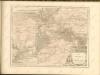
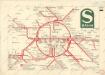
S Bahn

Blatt I Nauen, uit: Karte von Berlin und Umgebung in 12 Blättern
1 : 50000 Annotatie: Toelichtingen opgeborgen bij kaart; Annotatie geografische gegevens: Met schaalstokken: Meter, Schritt, geographische Meile Paul Schneider Berlin : Reichsamt für Landesaufnahme
Blatt V Potsdam, uit: Karte von Berlin und Umgebung in 12 Blättern
1 : 50000 Annotatie: Toelichtingen opgeborgen bij kaart; Annotatie geografische gegevens: Met schaalstokken: Meter, Schritt, geographische Meile Paul Schneider Berlin : Reichsamt für Landesaufnahme
Blatt II Oranienburg, uit: Karte von Berlin und Umgebung in 12 Blättern
1 : 50000 Annotatie: Toelichtingen opgeborgen bij kaart; Annotatie geografische gegevens: Met schaalstokken: Meter, Schritt, geographische Meile Paul Schneider Berlin : Reichsamt für Landesaufnahme
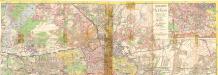
Umgebung von Berlin
Taschenplan von Berlin

Blatt VI Berlin, uit: Karte von Berlin und Umgebung in 12 Blättern
1 : 50000 Annotatie: Toelichtingen opgeborgen bij kaart; Annotatie geografische gegevens: Met schaalstokken: Meter, Schritt, geographische Meile Paul Schneider Berlin : Reichsamt für Landesaufnahme
Meßtischblatt 1834 : Wustermark, 1911
1 : 250000 Wustermark. - Aufn. 1901, hrsg. 1903, einz. Nachtr. 1906, gedr. [19]11. - 1:25000. - [Berlin]: Reichsamt für Landesaufnahme, 1911. - 1 Kt.
Meßtischblatt 1834 : Wustermark, 1903
1 : 250000 Wustermark. - Aufn. 1901. - 1:25000. - [Berlin]: Reichsamt für Landesaufnahme, 1903. - 1 Kt.
Meßtischblatt 1762 : Nauen, 1903
1 : 250000 Nauen. - Aufn. 1901. - 1:25000. - [Berlin]: Reichsamt für Landesaufnahme, 1903. - 1 Kt.
Großer Silva-Stadtplan von Berlin
1 : 23000 Berlín (Německo) Verlag für heimatliche Kultur Willy Holz
Plan von Berlin
1 : 25000 Berlín (Německo) Morin, F. H. F.H. Morin
Pharus-Plan Berlin
1 : 18750 Berlin : Pharus-Verlag