Maps of Kleinmachnow

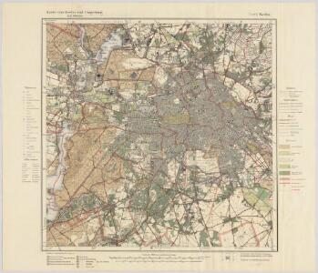
Blatt VI Berlin, uit: Karte von Berlin und Umgebung in 12 Blättern
1 : 50000 Annotatie: Toelichtingen opgeborgen bij kaart; Annotatie geografische gegevens: Met schaalstokken: Meter, Schritt, geographische Meile Paul Schneider Berlin : Reichsamt für Landesaufnahme
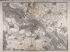
Umgebung von Berlin

Neuer geometrischer Plan der gesammten königlich-preussischen und churfürstlich-brandenburgischen Haupt und Rezidnez Stadt Berlin
1 : 79000 Berlín (Německo) Lotter, Tobias Conrad Tobias Conrad Lotter
Großer Silva-Stadtplan von Berlin
1 : 23000 Berlín (Německo) Verlag für heimatliche Kultur Willy Holz
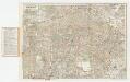
Strassenübersichtsplan von Berlin

Grundriss von Berlin
Berlín (Německo) Herzberg Veit Veit et Comp.
Taschenplan von Berlin
Plan von Berlin
[Kaart], uit: Silva-Stadtplan Berlin
1 : 22000 titelvariant: Berlin; Stadtplan von Berlin; Annotatie: Titel ook te lezen als: Berlin; Titel op omslag: Stadtplan von Berlin : im Gebiet der Stadt-Ringbahn mit Straßenverzeichnis u. Führer durch Berlins Museen u. Sehenswürdigkeiten; Editievermelding op omslag: Ausg. A 5; Verso: straatnamenregister Berlin : Verlag für Heimatliche Kultur Willy Holz
Die Königl. Residenz Berlin
1 : 8500 Mollova mapová sbírka Schleuen, Johann David Schleuen, Johann David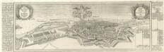
Die Churfürstlich-Brandenburgisch nun Königlich-Preüssische Residenz-Statt Berlin und Cölln an der Spree :
Mollova mapová sbírka Bodenehr, Gabriel Bodenehr, Gabriel
Pharus-Plan Berlin
Löwe, Cornelius
Pharus-Plan Berlin
1 : 25000 Berlín (Německo) Pharus-Verlag
Pharus-Plan Berlin
1 : 25000 Berlín (Německo : oblast) Pharus-Verlag
Pharus-Plan Berlin
1 : 28000 Berlín (Německo) Pharus Verlag
Meßtischblatt 3546 : Berlin (Süd), 1945
1 : 250000 Berlin (Süd). - Hrsg. 1903, bericht. 1919, einz. Nachtr. 1935, gedr. [19]38, Nachdr. m. farb. Eintr. der Gebäudeschäden 1945. - 1:25000. - [Berlin]: Reichsamt für Landesaufnahme, 1945. - 1 Kt.
Meßtischblatt 3546 : Berlin (Süd), 1938
1 : 250000 Berlin (Süd). - Hrsg. 1903, bericht. 1919, einz. Nachtr. 1935, gedr. [19]38. - 1:25000. - [Berlin]: Reichsamt für Landesaufnahme, [1938?]. - 1 Kt.
Meßtischblatt 1908 : Berlin (Süd), 1932
1 : 250000 Berlin (Süd). - Hrsg. 1903, bericht. 1919, einz. Nachtr. 1932. - 1:25000. - [Berlin]: Reichsamt für Landesaufnahme, 1932. - 1 Kt.
Meßtischblatt 1908 : Schöneberg, 1919
1 : 250000 Schöneberg. - Aufn. 1901, bericht. 1919. - 1:25000. - [Berlin]: Reichsamt für Landesaufnahme, 1919. - 1 Kt.
Meßtischblatt 3545 : Teltow, 1953
1 : 250000 Teltow. - Hrsg. 1903, [bericht. 1935/36], [mehrfarb. hrsg. 1937], letzte Nachtr. 1940/42. - 1:25000. - [Berlin]: MdI, 1953. - 1 Kt.
Meßtischblatt 1907 : Teltow, 1934
1 : 250000 Teltow. - Hrsg. 1903, bericht. 1919, einz. Nachtr. 1934. - 1:25000. - [Berlin]: Reichsamt für Landesaufnahme, 1934. - 1 Kt.
Meßtischblatt 1907 : Teltow, 1919
1 : 250000 Teltow. - Aufn. 1901, bericht. 1919. - 1:25000. - [Berlin]: Reichsamt für Landesaufnahme, 1919. - 1 Kt.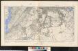
Meßtischblatt 1907/1908 (Doppelblatt) : Teltow/Schöneberg, 1919
1 : 250000 Teltow/Schöneberg. - Aufn. 1901, hrsg. 1903, Aufldr. 1919. - 1:25000. - [Berlin]: Reichsamt für Landesaufnahme, 1919. - 1 Kt.
Meßtischblatt 1907 : Teltow, 1901
1 : 250000 Teltow. - [Aufn. 1888?]. - 1:25000. - [Berlin]: Reichsamt für Landesaufnahme, 1901. - 1 Kt.
Meßtischblatt Sect. Teltow
1 : 250000 Sect. Teltow. - Aufgen. 1874, hrsg. 1877, einz. Nachtr. 1892. - 1:25000. - [Berlin]: Reichsamt für Landesaufnahme, 1892. - 1 Kt.
Meßtischblatt 3446 : Berlin (Nord), 1945
1 : 250000 Berlin (Nord). - Hrsg. 1903, bericht. 1920, einz. Nachtr. 1932. Gebäudeschäden im Gebiet der Stadt Berlin / Stand 1945. - 1:25000. - [Berlin]: Reichsamt für Landesaufnahme, 1945. - 1 Kt.
Meßtischblatt 3446 : Berlin (Nord), 1932
1 : 250000 Berlin (Nord). - Hrsg. 1903, bericht. 1920, einz. Nachtr. 1932. - 1:25000. - [Berlin]: Reichsamt für Landesaufnahme, 1932. - 1 Kt.
Meßtischblatt 1837 : Berlin, 1918
1 : 250000 Berlin. - Aufn. 1901, hrsg. 1903, Aufldr. 1918. - 1:25000. - [Berlin]: Reichsamt für Landesaufnahme, 1918. - 1 Kt.
Meßtischblatt 3445 : Spandau, 1945
1 : 250000 Spandau. - Aufn. 1901 und 1927/34, bericht. 1936, hrsg. 1936, redakt. Änd. 1938. Gebäudeschäden im Gebiet der Stadt Berlin / Stand 1945. - 1:25000. - [Berlin]: Reichsamt für Landesaufnahme, 1945. - 1 Kt.
Meßtischblatt 3445 : Spandau, 1938
1 : 250000 Spandau. - Aufn. 1901 und 1927/34, bericht. 1936, hrsg. 1936, redakt. Änd. 1938. - 1:25000. - [Berlin]: Reichsamt für Landesaufnahme, 1938. - 1 Kt.
Meßtischblatt 1836 : Spandau, 1936
1 : 250000 Spandau. - Aufn. 1927/34, bericht. 1936. - 1:25000. - [Berlin]: Reichsamt für Landesaufnahme, 1936. - 1 Kt.
Meßtischblatt 1836 : Charlottenburg, 1920
1 : 250000 Charlottenburg. - Aufn. 1901, hrsg. 1903, bericht. 1920. - 1:25000. - [Berlin]: Reichsamt für Landesaufnahme, 1920. - 1 Kt.